Blog
22/07/26
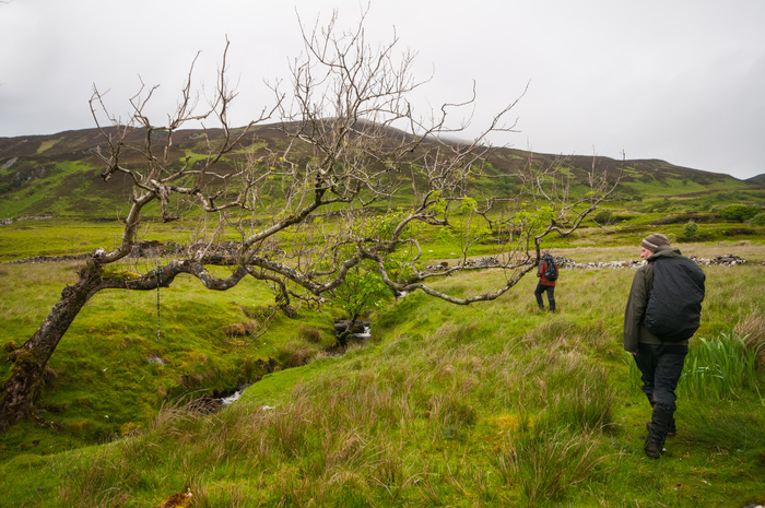
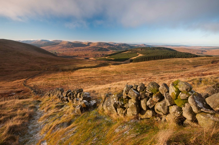
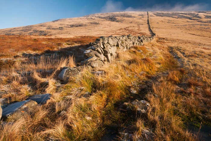
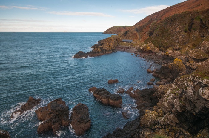
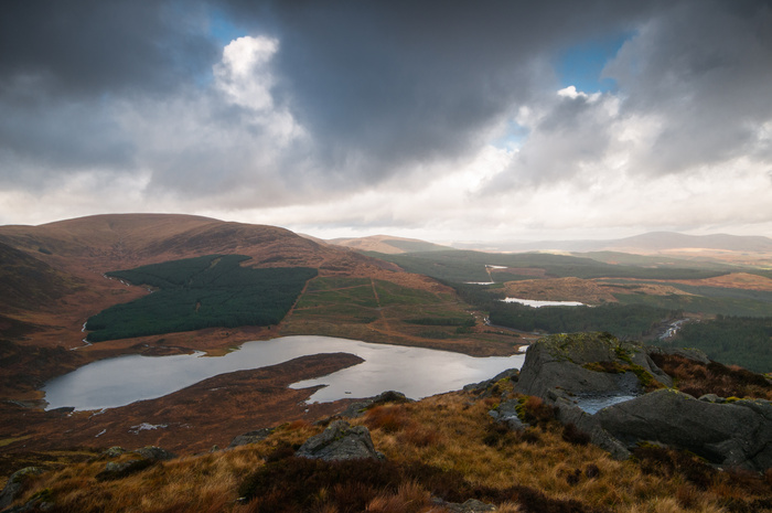
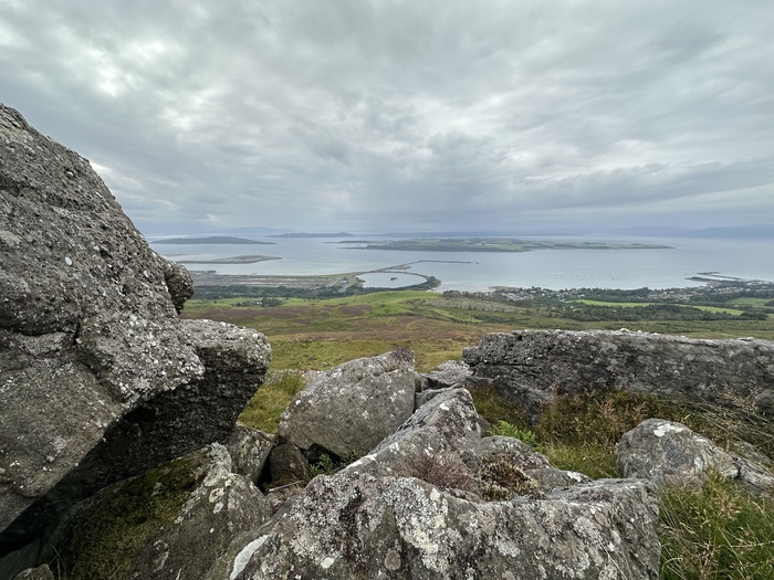
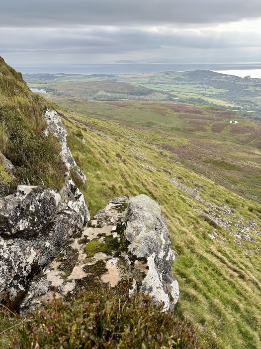
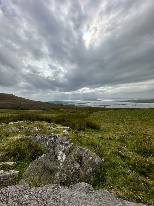
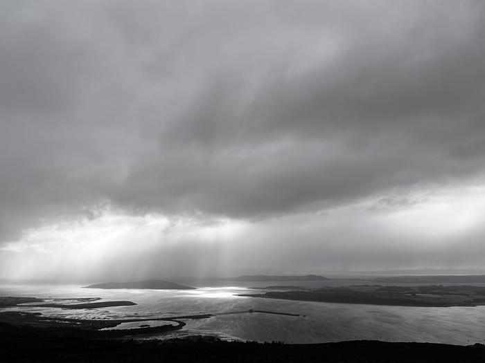
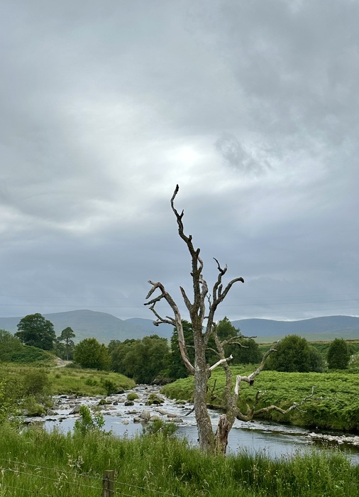
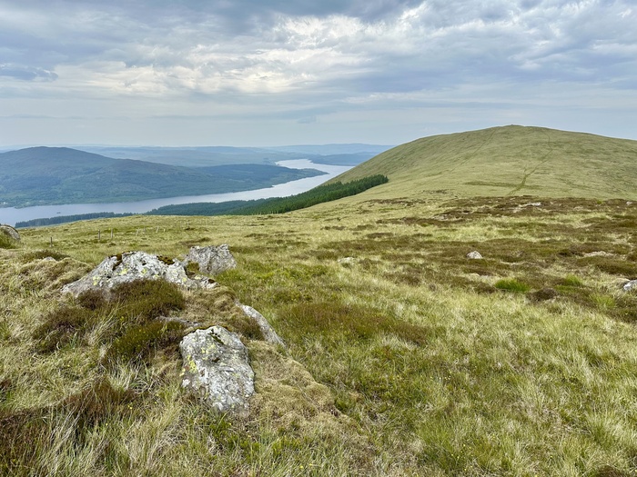
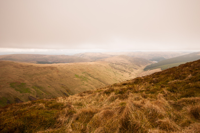
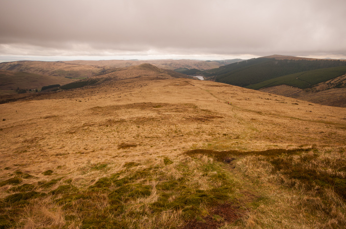
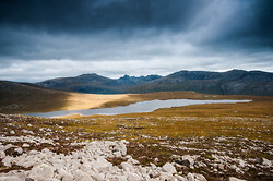
A trip back to the Galloway hills with a friend to walk the 4 lochs route to the Merrick. Sounds nice in theory, but to choose the hottest day of the year, with the temperature touching 30 degrees on the hills was a mistake. Give me cold weather for walking any day! Coupled with clegs biting and swarming, and atrociously boggy underfoot conditions, it was a day I only intermittently enjoyed. Highlights are below -
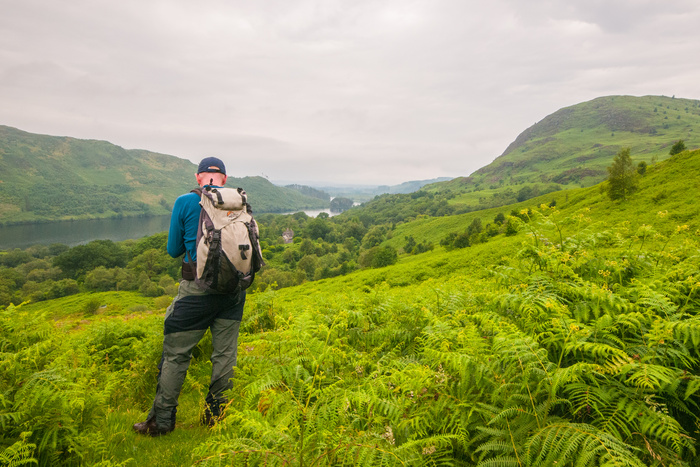
Looking back to Loch Trool from Buchan Hill
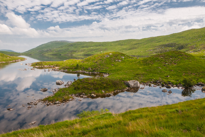
Looking down to beautiful Loch Valley
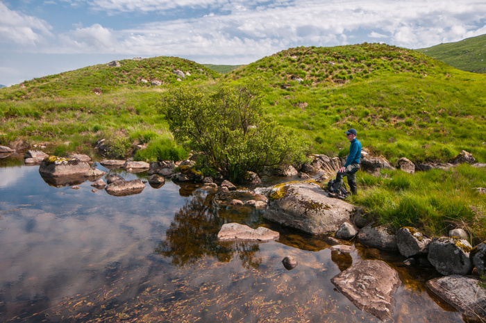
Enjoying a break by the loch
I've never been a great fan of landscape photography over the Summer, for all the main reasons of light etc, and so I'll be taking a bit of a break from the hills until September. The plan then is to do two days on the Arran hills, camping high on the Caisteal Abhaill ridge. Already looking forward to it!
11/06/26
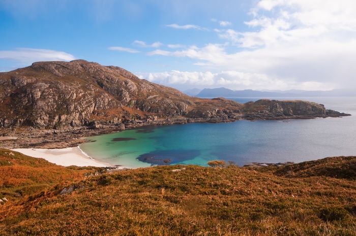
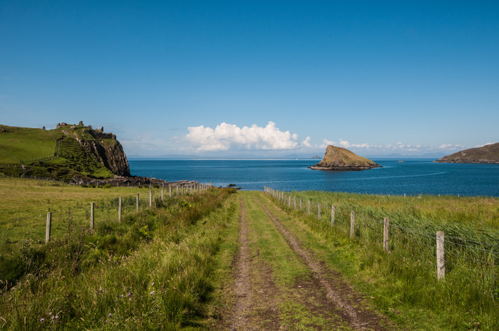
It's been a while since I updated this, but I haven't done much walking recently. Despite the supposed UK heatwave (England only), the weather has been the standard rubbish. Went to Skye a couple of weekends ago for the old boys annual reunion, and whilst a goodtime was had by all, the weather was fairly atrocious. Apart from day one, where I had an excellent walk around the foot of Ben Tianavaig (phone image below )
I even managed some swimming here, although the water was on the Baltic side!
Over the weekend we had planned to walk the massive bulk of Corbett, Beinn Na Cailleach ( Hill of The Old Woman) a 732m high lump near Broadford, it rained and rained. The cloud cover was down to about 300m, so we decided it would be both unpleasant and potentially dangerous to climb its 3 peaks. Instead, we decided on the 13km low level coastal walk to the twin Clearance villages of Boreraig and Suisnish - a poignant place indeed (phone pic below)
The rain actually did hold off for most of the day, but the low cloud persisted, so it was a good choice. There were some nice scrambly bits on the path, and good views despite, or maybe even because of the poor weather
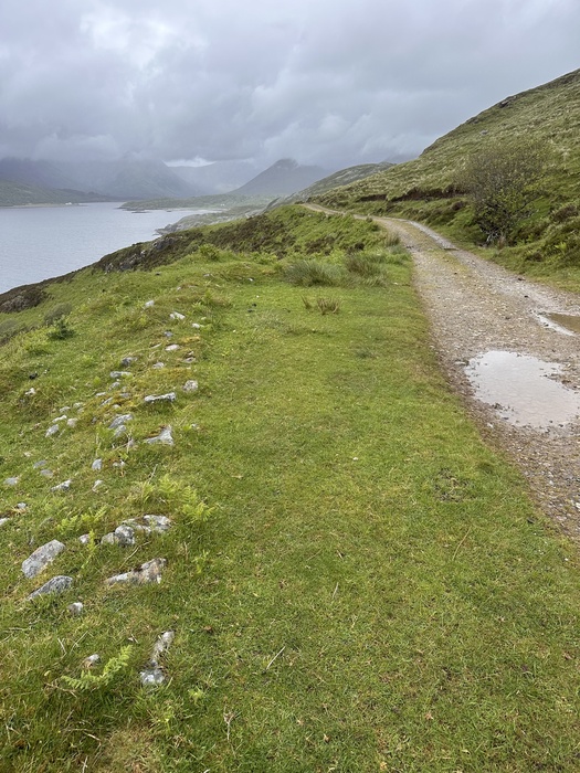
A lot of tourists though! We used two cars, so cut a few kilometres off the
Walk Highlands Walk here. (Note never, ever take an Audi or other low-slung vehicle on the track to Camus Mallag as it's virtually undriveable)
14/04/26
Back In The Galloway Hills
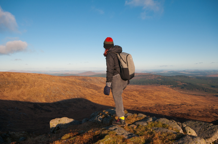
On a bright, but cold Saturday, my eldest daughter and I fond ourselves heading down the road again into Dumfries & Galloway, to tackle the 814m summit of Corserine, the second highest hill in the area.
It was sunny, and dangerously close to being warm as we headed up the single track road towards our starting point of Forrest Lodge.
However, that illusion was to be swept aside as we headed up out through the trees and onto the bare, and surprisingly rugged in patches, slope of the hill. We found some nice rocks for a quick scramble
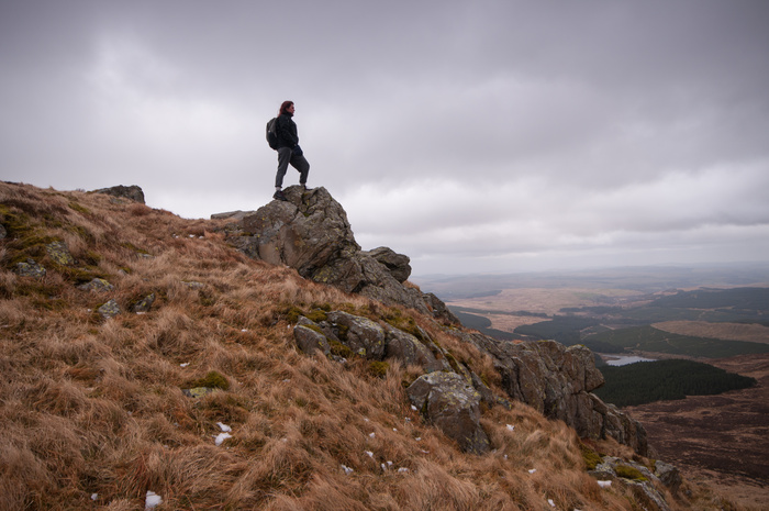
before we set up off over wet ground and increasingly patchy snow towards the summit plateau. The wind by now was gusting at 60mph, so it was a quick route march to the trig, before we headed back to the shelter cairn for a lunch stop.
By the time we got back down to the car park a couple of hours later, it was warm enough to brew up a cup of tea, and sit on one of the wooden picnic benches near by. A great walk, and only two people encountered all day. Result!
23/03/26
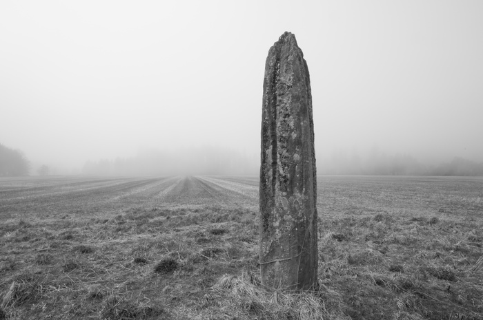
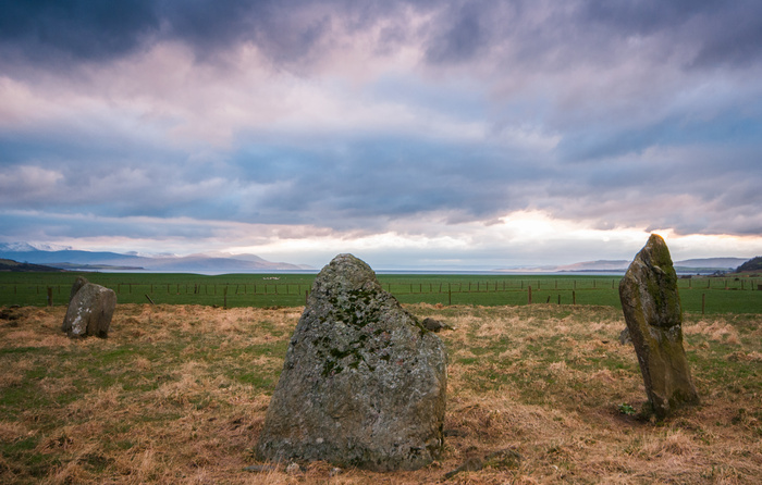
On The Megalith Trail
Friday last was looking excellent weather wise, so I took the day off work and headed over to Cumbrae to photograph a Menhir (single Standing Stone) which I'd read about online. Known as the Gouklan Stone, it's located in a small wood up the hill from the ferry terminal. Unsignposted, there is no way you'd know about it, as you can't see it from the road. Consequently, it doesn't seem to get much traffic, and when I visited I had the place to myself
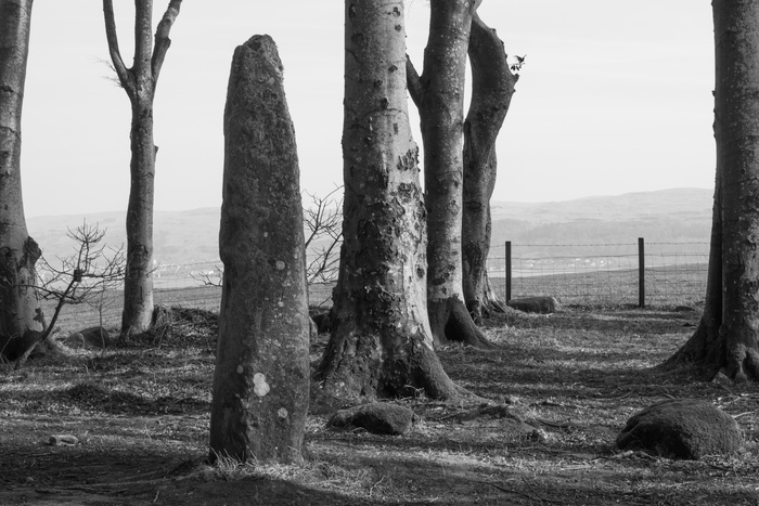
The following day was meant to be a hillwalking day on Arran, but the mist meant a change of plan, spent exploring some more stones in a field near Brodick
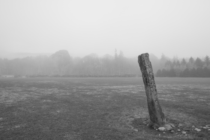
On one side of the road behind a very high hedge, completely screening what's behind, is the lonely, tilting Stone C
Across the other side, behind an equally high hedge, are stones A&B. The mist leant them a surreal atmosphere, and as there wasn't a soul about (unlike the rest of the island), I was at liberty to wander round taking shots from different angles

Not the day I had planned, but a fine one nevertheless. And, a new photozine in development, documenting my favourite stones. Next stops include Skye, Jura, Islay & Gigha
01/02/26
Back To Bute
With a mate up visiting, it offered me a chance to head back to Bute for a bit of walking and photography. The weather had been a bit miserable, but the planned trip on Thursday was it looking promising as we boarded the ferry at Wemyss Bay
We'd decided to walk the southern Loop of the West Island Way ending up at the Kingarth Inn for lunch. Sometimes it's hard to believe that you're not in the Hebrides on this southern end of the island.
There wasn't a soul about as we wound our way around the rocky fringes of the path towards Glancallum Bay, where we stopped for a brew and a biscuit
Up and over we went to St. Blanes church, where I discovered a 10th Century Viking gravestone which kind of blew my mind!
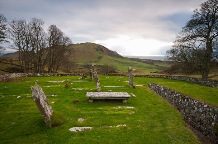
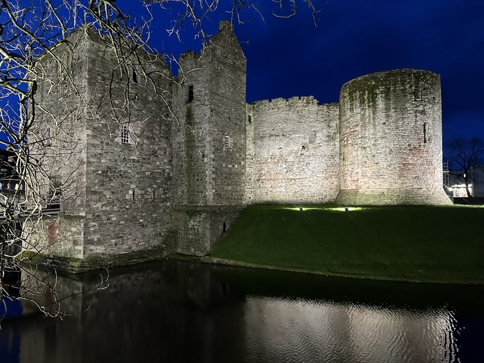
After lunch there was a quick spin up to Ettrick Bay to look at a megalithic stone circle & the back to Rothesay for a look at the castle under the lights. Great end to a great day...
06/01/26
Welcome to 2026!
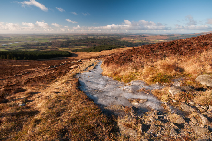
The new year's hillwalking was kicked off last weekend with another trip to the Galloway Hills, this time Cairnsmore Of Fleet, Scotland's most southerly mountain (over 2,000 ft). It was forecast to be fine and sunny, albeit with a summit temperature of minus 6 degrees (with wind chill minus 13 degrees - ouch!). I'd planned a 5 hr circuit of the hill, so I was glad of my older daughter's company. Surprisingly, or maybe not given the cold, we only saw another 5 people on the hill all day. After a bit of faff at the start, we found ourselves heading up and through a seemingly never ending forest plantation. When we did eventually emerge, it was into bright sunshine, and a path completely iced over in places.
I didn't mind that, as it added some interest to the hill itself, which is quite dull on its western flanks. The view back to the River Cree were excellent though.
Pretty soon we were on the summit and heading south for the subsiduary top of Knee Of Cairnsmore. This side of hill was much more interesting, overlooking a large bowl-shaped corrie, with hills and moorland rolling away to the north west.
From there we descended through the low cliffs on the Door Of Cairnsmore down to the moor below, where we picked up a track leading all the way back to our start point. An excellent day out, and I even got to try out my new Jet Boil stove!
10/12/25
Cairnsmore of Carsphairn (In Sunshine this time)
Having tackled this 797m hill in the Summer in poor visibility, I was keeping a close eye on the weather for an opportunity to take in the views properly and get some decent images. So, a fortnight ago, the forecast was for clear weather (minus 4 and sunny on the summit), so I headed off back south to Galloway. I decided to tackle the hill from the western flank, and come back down via the Black Shoulder and Dunool, making a nice little round of about 4 hours.
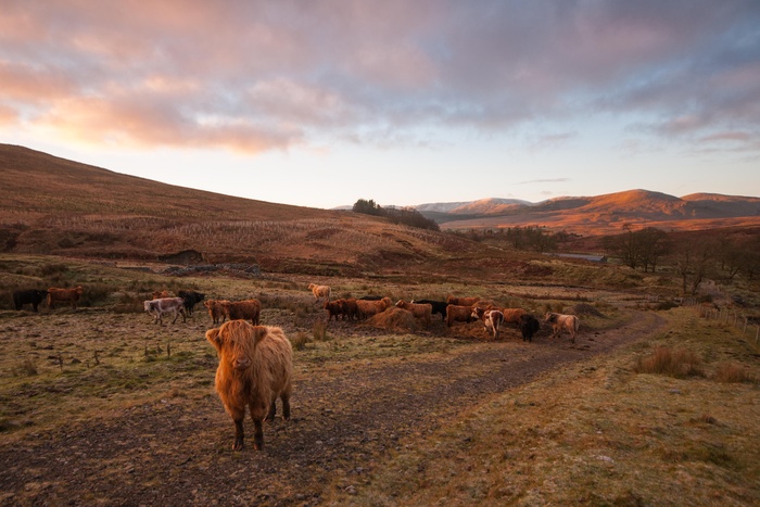
My only human, or non human encounter all day came with these lads. This young Highland bull was more skittish and nosey than dangerous, but he came up close for a proper look to see who was on his track!
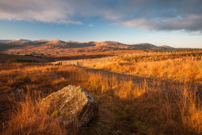
As I started to climb higher on the track, the sun came up and cast a golden light on everything. The view back to the Rhinns Of Kells range was superb.
Leaving the track and heading on to the hill path, more height was gained quickly. As the ground was frozen underfoot, it was great to walk on. Oh, and I had my new Spanish Bestard walking boots on - excellent!
Approaching the summit ridge, the last of the mist cleared off the top, leaving a pleasant amble down in bright sunshine. Really glad that I came back to tackle this hill again. And, as I said above, the only mammals were the hairy coo kind. Not a single other person on the hill all day. Bliss!
21/11/25
The Ayrshire Coastal Path (Part 2)
Last Friday was forecasted to be sunny, so I decided to take the day off work and complete the remaining bits of the coastal path. I headed down to Glen App, where the official route starts. But of course, I wasn't going to actually walk the official route. I noticed that there was a place to park at Finnart's Bay at the very southern part of Glen App. A cliffwalk from Garry Point heading north, meeting the official route (which boringly heads inland ) when it finally reaches the coast at Currarrie Port, sounded much more fun. I was starting to wonder if I'd made the wrong choice five minutes in, as I found myself scrambling up a steep muddy bank, having to negotiate a couple of sheep fences. This certainly wasn't an official route for anything. However, pretty soon I picked up a faint path through bracken (which would be nightmarish in the Summer ) and continued along a steeply contouring hillside, with the cliffs perilously close on the left
It was at this point that I knew that I had in fact made the right choice. There was a stiff, cold NE breeze blowing, but this route was sheltered all the way along this section, and once the sun came out, the jacket came right off - fantastic!
A few kilometres along, I came across this excellent waterfall, plunging 50 metres, in a series of drops, to the sea. I didn't have my tripod, so used my walking pole as a substitute to drop the shutter speed. It was semi-successful on this image, but I was unable to capture the height due to the configuration of the falls. In fact I found myself suck in a bramble bush at one point, trying to get a shot. Pleased to report I made it out - just.
Next up along the coast was this wee holiday cottage by the shore at an inlet named Portandea. What a spot. And, just before I took this shot, a herd of feral goats stopped to see what was walking along there patch. Also spotted today was a herd of red deer, a fox, and I forgot to mention the dozens of daft pheasants at the start of the walk - squawking about in a mad panic. I continued along for a bit before heading back to the car to drive up to Lendalfoot to walk another missing section
.....and then up to Ayr for a shot of Greenan Castle which I couldn't get last week
I guess it would be irresponsible of me to recommend this alternative route, as it was quite dangerous in places, with no protection from the cliffs, but what a day!
09/11/25
The Ayrshire Coastal Path
Sometimes you do something without realizing it. The Ayrshire Coastal Path runs for 106 miles (170.5) from Skelomorlie in the north to Glen App in the south. It's a fairly serious undertaking to walk the whole length of it, but I've walked half of it without trying. Well, not exactly not trying, but when I look at the sections online, it seems that I've walked pretty much from Ayr north. So, on Sunday I decided to walk from Dunure to Culzean Castle and back
The morning had been very wet, but the afternoon forecast was decent. Still, I thought that high tide at 1.30pm would keep people off the walk, but I was wrong about that. There were other idiots with their dods skidding about on the seaweed and rocks at the top of the shore, and it was a bit of a struggle to get to Culzean Castle. I noted a dean porpoise on the beach at Croyburnfoot. Apparently the dolphins attack them. So much for gentle dolphins then.
It was a struggle to get a clear shot below that castle, as people annoyingly kept coming down to the beach. Having managed to finally get one, I headed up the steps and back down the other side the way I came. The beach was much bigger now, but consequently busier.
Dunure Castle is an atmospheric ruin, and I spent a bit of time wandering about trying to get a decent shot
I'm now fired up to do the rest of this route, and with Friday looking good, I'm going to point the car south again
03/11/25
The Rhinns Of Kells
I'd been waiting for a clear day to do these hills in the heart of Galloway, and Saturday, the firs day of November, turned out to be that day. It had been raining heavily all night, and was still raining when I left the house at 7.45 a.m. It was a brisk spin down quiet rods however, and I was in the car park at Forrest Lodge by quarter past nine, waiting for the rain to go off. And right on cue, it did. There was not a soul about, and apart from the one forestry worker passing me in a hi-lux truck about 5 minutes in, I wouldn't meet another person until I got back into the house late afternoon. Hill bliss! It's a pleasant but upwards walk along forestry tracks

until you turn onto a very short path and emerge suddenly onto the open hillside. A short rise gives you the first proper view across to the Corbett of Corserine
Then a very short but steep section takes you onto the slopes of Meikle Lump. The rocky path and several small burns and mini-waterfalls had merged into one, and it was a treacherous mess. I new that my feet were going to get soaked, and I was extremely glad to have borrowed one of my wife's Nordic trekking poles (Leki - in case anyone is interested). I'm at the age now where lots of knee abuse (walking, scrambling, football etc) is starting to haunt me, and so I felt the sensible move would be to use a pole on the hills. And I was really glad I did, as I splashed and slid across and upwards. The ground was so wet in places that the earth was coming away with the weight of my boot. It was going to be one of these days when you tell yourself that the effort will be worth it for the views and photo opportunities. Both the light and the wind were intermittent, making it alternately cold and hot.

Heading further up the lump, I was rewarded with some outstanding rays of light over Clatteringshaws Loch, as I hunkered down out of the wind.
The over the next rise I got this view of Loch Dungeon and Corserine
Buoyed on by this, I plugged on to the top of Meikle Millyea (741m), and undistinguished hill, but one where the views from it are outstanding

I decided that I wasn't going to do the rest of the ridge today, as the good light was getting less frequent. I just wanted one further decent image coming down the rocky slopes of Meikle Lump

I was pleased with that. I could put the camera away, and concentrate on staying upright. I knew that I was going to come a cropper on that initial scramble, and sure enough, the pole ended up in the water, and I ended up on my backside! All in all a great day, but I vowed to get decent 4-season walking boots. I've since ordered a pair of Spanish made Bestard boots (£110 off the price!) which have had excellent reviews online. With these and my walking poles, I should be cutting about on the hills for a wee while yet..........
27/10/25
I can't believe it's a month since I updated this! I suppose an excuse might be that I've been away on holiday for two weeks, so there's some sort of excuse........
Anyway, when I got back from Orkney, there was the small matter of the Tidelines Book Fest Talk to contend with -
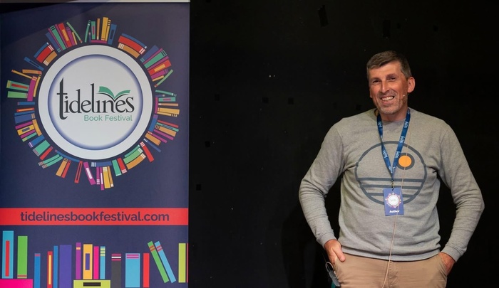
The event was in the excellent Harbour Arts Centre in Irvine, where I've been several times, and I was due to speak in the auditorium. I was fully expecting an audience of around 25, so I was quite shocked that 63 people had paid to hear me burble on for an hour! As I stumbled onto the small stage, the lighting meant that I could only see the people in the front row, which calmed me down a bit. However, glancing to my right I noticed poet Jackie Kay sitting and waiting intently for my words of wisdom. Now, Jackie is somebody I admire and respect, so there was a blast of concurrent activity through my brainwaves about making this talk good and the same time as a mild feeling of panic..........Anyway, it must have gone ok, as Jackie came over afterwards to introduce herself and say how much she enjoyed it. I felt quite pleased with myself!
27/09/25
An Orkney Road Trip - Day 1
The long awaited road trip to Orkney dawned cold and fair. Well, it would later, but I started the car at 4.50 a.m, and the sky was still completely dark. The beauty about leaving this early was that the roads were very quiet, quieter even than I thought they might be. Up through a sleeping Largs, over the Hailie Brae and through a quiet Glasgow, and onto the motorway up Stirling. The A9 was a joy to drive on, no motorhomes or lorries clogging things up, and I was over the Kessock Bridge past Inverness in 2hrs 37. My first stop for a leg stretch was just after 9 a.m at Loch Fleet in Sutherland
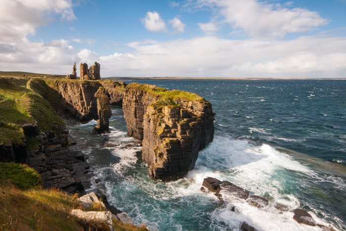
And then it was up to Caithness, where I had planned a couple of walks. First stop was Castle Sinclair Girnigoe near Wick, where is was both sunny and breezy. A great combo for capturing a ruined castle perched on a rocky headland.
After a passible cooked breakfast at Wick Tescos, it was on to Duncansby Head. The car park was busy with NC500-ers, who I gave a wide berth to and headed out past the stacks
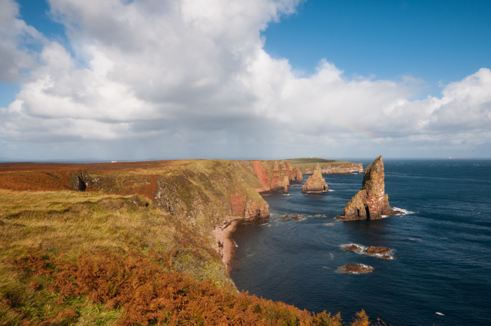
The light was brilliant. Alternately sunny and showery, it was showing off the stacks to their best advantage. Nobody else had ventured out this far along the coast, so I got the place all to myself.
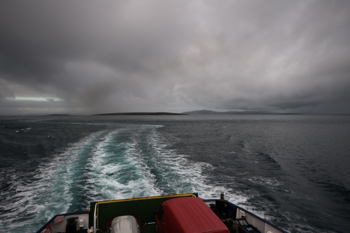
I still had a couple of hours to kill before the ferry to St. Margaret's Hope on Orkney, so headed along the Thurso Road to a ferociously windswept Dunnet Bay.
Great Light though. The ferry was just over an hour, and there was still a bit of light in the sky as I headed up to the hostel in Kirkwall. It was good to be here.......
Day 2
My first full day on Orkney was forecast to be very wet & windy. I'd slept fitfully in the hostel, but it was a step up from my original plan to camp, and looking out of the window I was extremely glad to be able to pop next door and brew up a mug of tea under a roof. Given the weather it seemed like a good plan to head somewhere coastal - the cliffs along from Brough Of Birsay would be ideal
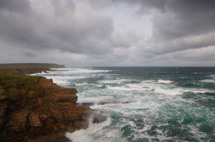
And so it turned out to be! I had an excellent, if intermittently wet, morning getting buffeted by a sou'westerly gale. Heaven.
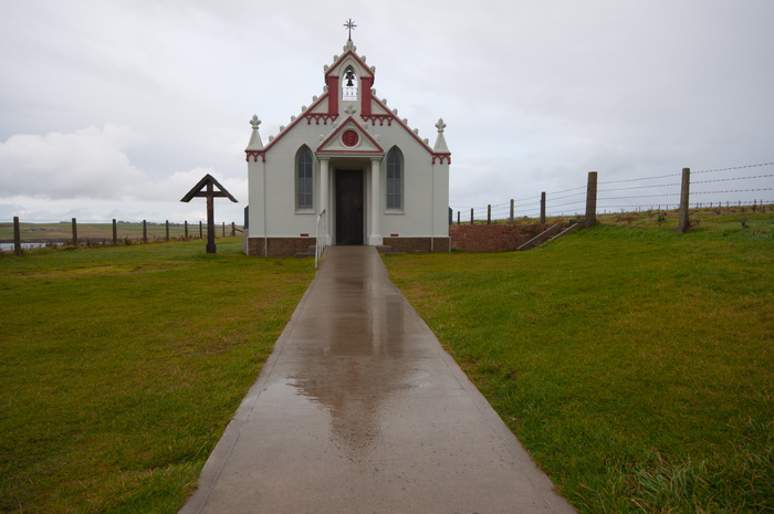
After being fed and watered at a pleasantly old-fashioned caff in Stromness, I headed to the Italian Chapel on Lamb Holm. It was built during the Second World War by Italian prisoners of war, who were housed on the previously uninhabited island while they constructed the Churchill Barriers to the east of Scapa Flow. Only the concrete foundations of the other buildings of the prisoner-of-war camp survive.
Day 3
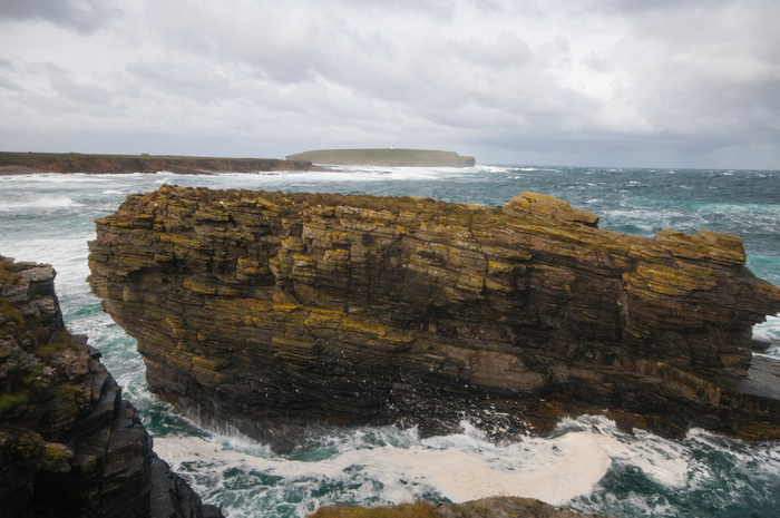
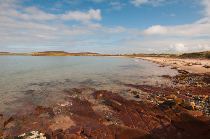
It was off to the island of Eday next
The weather was dry, but very gloomy, as you can see from the above image. There was a 5km walk from the pier to the Community Hostel (I'd decided not to take the car across, both to save money and get my steps in!). The hostel was well fitted out, and there was only one other person staying, a local guy who was giving fire training to some islanders. The fire station (volunteer) was next door. I had a lot of walking planned, so set off on a circular walk taking in a couple of beaches
The Sands Of Doomy turned out not to be very doomy at all, as the sun had come out. Four very nosey grey seals followed me from the shallows as I walked down the length of the beach, in bare feet no less! My plan for the afternoon was a for a bit of Neolithic action.
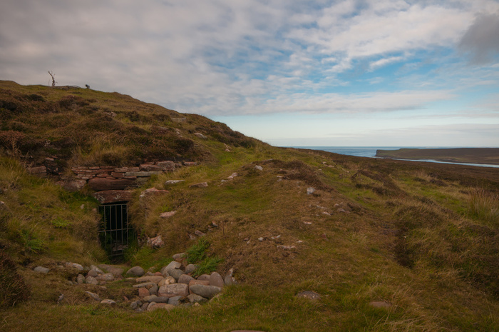
Vinquoy chambered cairn is a restored Maeshowe-type Neolithic tomb. The tomb is around 18 m (59 ft) in diameter with a height of 3 m (9.8 ft), and was constructed with red sandstone. It has a 5 m (16 ft) entrance passage leading to a central chamber with four small side-cells. The chambered cairn is partly below ground, carved into the hill. Did I crawl in? You bet I did. It was surprsingly cool and dry in there. There was a kind of magical stillness about the place, and I had to drag myself back out.
At the bottom of the hill the Stone Of Setter is located. It dates to the Late Neolithic or Early Bronze Age, probably around 2nd millennium BC.[3] It measures approximately 4.5 m (15 ft) in height. It was about 5 p.m by now, and I still hadn't met anybody all day. I'm not sure that there are many places in the country you could do that. And then it was back to the hostel where I managed to burn the top of my steak pie by switching the grill on by accident. Still, it was delicious & a great end to the day.
Day 4
For my final day, I was heading back to the (Orkney) Mainland & meeting with two excellent local photographers, Ingrid Budgeand Frances Scott. I'd done an exhibition with Ingrid in Glasgow in 2018, and she was now working as a part-time tourist guide back in the islands. Frances has recently moved back to Orkney after a spell working at Glasgow School Of Art. We were planning a walk to the cliffs of Yesnaby on the west mainland, and I knew it was going to be both an interesting and informative day. First stop though, The Ring Of Briodgar
Ingrid got quite animated as we got close, and explained that it was one of the few times this year that the inner ring is open to the public. Normally, you have to view from further back. As the tourist coach left, I got the feeling that my timing was unusually good today!
The ring of stones stands on a small isthmus between the Lochs of Stenness and Harray. These are the northernmost examples of circle henges in Britain. It is generally thought to have been erected between 2500 BCE and 2000 BCE, and was, therefore, the last of the great Neolithic monuments built on the Ness. What a place!
Then it was on to Yesnaby where we walked out to the massive sea stack, and found some fossils in the rock, which I've forgotten the name of now. A great end to my last day on Orkney
01/09/25
A couple of days after I get back from Orkney, I'll be appearing at Tidelines Book Festival in North Ayrshire Facebook post here to talk about my Islands Photography Book. If you are in the area at all in September, please come along and ask me any questions!
19/08/25
Kaim Hill
Another local walk. Kaim Hill at 387m sits a couple of kilometres behind our house, although the view is blocked by trees. It's the highest hill in the area walkable from the house, and the views from the top give an excellent view in all directions.
It was an extremely warm afternoon, with the heather in bloom across the moors, when I headed up through the woods and onto the lower slopes of the hill. This side of the hill is pathless, but if you're careful, a route can be picked out through the drier grass onto the rockier upper slopes
Inevitably there's a breeze up here, even on a hot day, and the large boulders offer an excellent place to shelter and enjoy the views
There is even a rock band below the summit plateau which offers some very mild scrambling on loose rock. All in all and excellent walk.
08/08/25
Whatside Hills
An 8km out and back evening walk from the house. I'd been up Fairlie Glen and Kaim Hill (387m) several times, but I decided to turn left and bog trot up to the Whatside Hills, which run as an escarpment above the Kelburn Estate and then as featureless bog east to the Windfarm. The ground was surprisingly firm underground, but the walk acted as a reminder as to why you should always check wind speeds
It's a steady climb from our house at sea level to around 330 metres (just over 1,000 feet) of ascent, and the wind increased in speed, from t-shirt and shorts weather to putting on a swetashirt-andd-I'm-still-quite-cold kind of weather. I couldn't help but think of a similar day on Ben Wyvis, a good few years ago when it was boiling hot at the foot of the hill, but by the time we crested the summit plateau, the wind was howling and driving wintry hailstones in our faces. Thankfully I'd lugged full Winter kit up in my rucksack! A salutary lesson.
Back to the Whatside Hills- I was quite glad to get back down the slopes and out of the wind. The light was amazing though.......
07/08/25
Path To Kilbirnie - An Edgeland Walk
From the Camphill Reservoir on the A760 from Largs to Kilbirnie, the excellent, and usually reliable Geograph site showed an overgrown path over the hill, passing a couple of ruins and curving back down to Kilbirnie. A there and back of around 10km, it seemed an intriguing walk for a warm Summer evening. Leaving the cat in a lay-by, I crossed the road, avoiding a scary 100m verge walk to the gate, and headed straight up. Of course, that immediately put me off course, and it took me a bit of time to find the path. Peering through the windows of ruin number one, I couldn't help but hear Kate Bush 'Wuthering Heights' running around in my brain
The path pretty soon became boggy and non-existent in places, but as it followed the course of an old wall to the forestry plantation, there was no problem with route finding. I had to push through young trees which were obscuring the path, and stopped at ruin number 2 for a rest. Forestry operations had been clearing this side of the plantation, and I came across this tower
At first I thought it might be a lookout tower for grouse shooting, but I'm not sure Forest Enterprise would allow that. Who knows?
(All images on the above posts taken with phone)
04/08/25
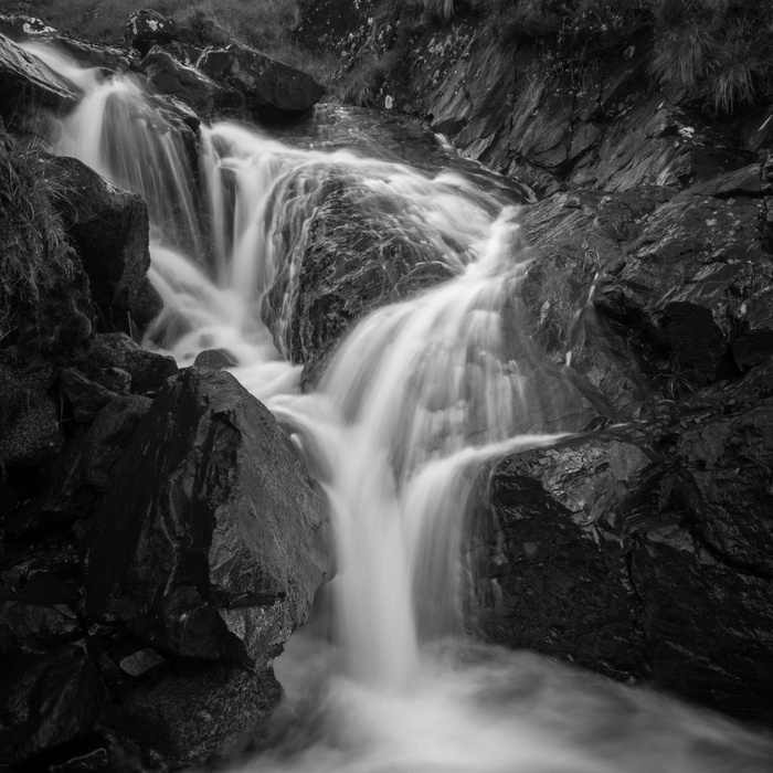
Updated photos of Cairnsmore of Carsphairn
Due to the overcast/misty nature of the day, these images worked better in monochrome.
28/07/25
Back To The Galloway Hills
Cairnsmore Of Carsphairn at 797m (2,625ft) is one of the most southerly Corbetts (Hills over 2,500ft)in Scotland. Despite it being a cloudy and claggy day on Friday, my son and I headed down the road to tackle this one and its lower summits. Our original plan had been to walk Corserine and the Rhinns Of Kells hills, but low cloud forecast led to a change of plans
The Start of the walk
It was a brisk walk up the track to the base of Dunool, and then a surprisingly steep ascent up to the 541m summit. By this time, the mist had swirled in and it was a slog up to the Black Shoulder, where the gradient eased off and we were able to follow the path quickly to the summit.
My prediction for the mist lifting was as usual, wrong, but within 5 minutes of heading back down it started to clear, and we were rewarded with cracking views to the south and west
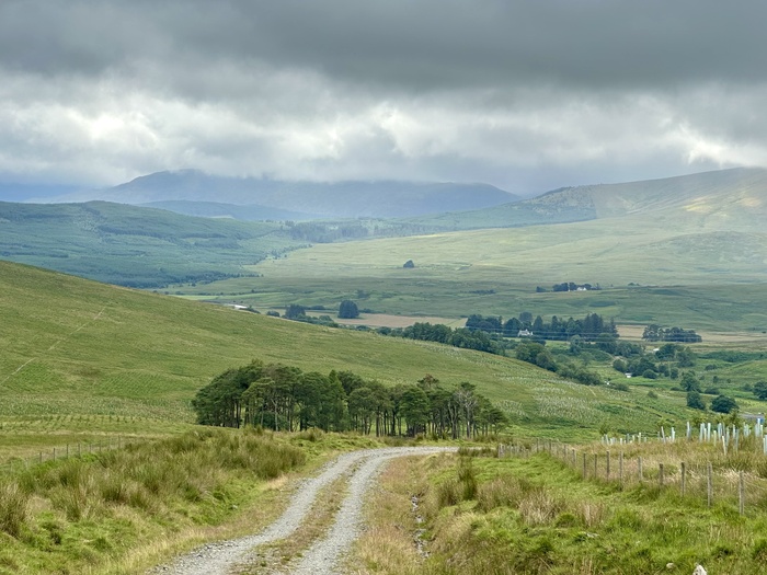
Overall a great day, and with the mist lifting on the way back, great views too. Overall walk time - 4 hours
03/07/25
Staying Local
Whilst England was being 'heatbombed' last weekend, we were basking in blustery conditions, although there were plenty sunny spells, making it perfect walking weather. I decided on an 8km circuit from the house, which turned out be be boggier & tougher than I would have liked. Heading up through the fields across to Kelburn Estates and up to the viewpoint, the Firth Of Clyde was looking fine in the sun.
I carried on up the track, past a lonely estate cottage, which looked like it was getting new windows fitted, and then hard right up the hill and across the moor to Fairlie Glen
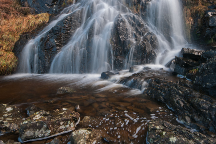
The going alternated between easy turf, and sodden moorland, but with always a surprise like this waterfall below to delight

I eventually reached the top of the Glen path, and it was literally downhill from there. Despite picking up an unwanted friend (a sheep tick), a great jaunt out.
24/06/25
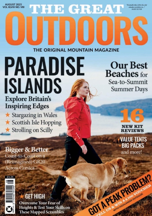
The Great Outdoors Magazine
6 page article in the August Issue of The Great Outdoors Magazine - available from 27th June
22/06/25
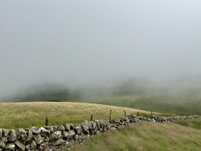
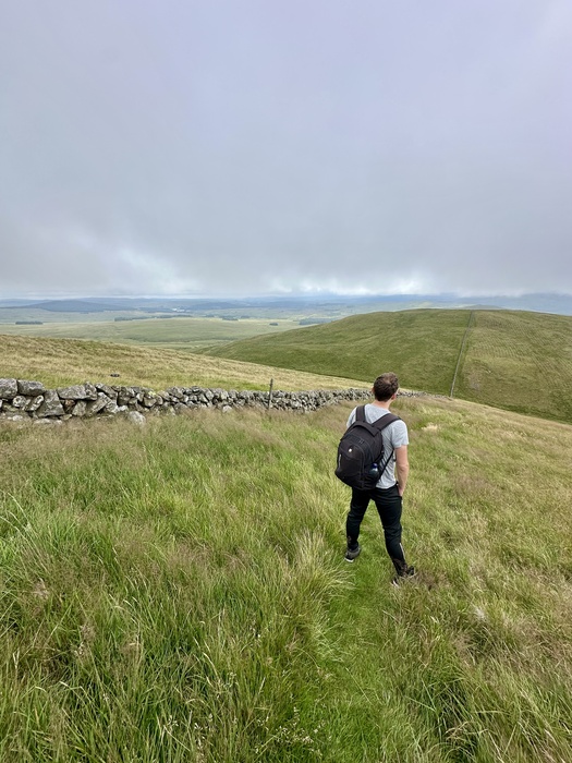
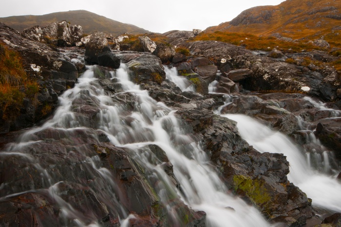
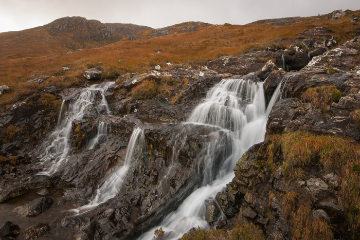
A Jaunt Up The Galloway Hills.
Midsummer. The Summer Solstice & the hottest day of the year. What better way to celebrate than a trip up the hills
For a change I decided to head south into (for me) previously uncharted territory. The Galloway district has a number of decent sized hills, in fairly remote country. And with the added advantage of being only 75 mins drive down the road, I decided to to tackle a couple of the northerly outliers of the ridge known as the Rhinns Of Galloway.
Leaving the car by the bridge just north of the village of Carsphairn, it was a pleasant stroll up a farm track, heading across a floodplain with hints of a neolithic past - a small ring of standing stones, a mound (possibly burial), and a celtic slab stone which has been built into a drystone wall. A couple of further kilometres takes you to a deserted lead mining village which last saw production in 1873. And then it's a slog to the top of Coran Of Portmark (623m). There is a no existent path on the OS map, but about 200m further north there is an ATV track which takes you across the slopes of Knockower and up to the summeit. Unfortunately I didn't discover it until an hour of horrendous bog-stumbling, sweating and fighting off clegs. I wandered along to summit of Bow I took some phone shots of Loch Doon off to the north
Views from Bow summit
11/06/25
3 Walks exploring the Sleat Peninsula On Skye
Last October, a great few days of walking was had by a group of us on the Sleat peninsula on Skye. We were the guests of old school friend Andrew MacDonald and his sister, who run the Flora MacDonald Hostel in the south end of the island. The hostel itself is tucked up a side road in Kilmore, and enjoys stunning views across to Knoydart on the mainland.
It was an opportunity for those who still live on the island, and those from further away to meet up for a few days of good craic and good trekking. Fortunately, we were blessed with perfect walking and photography weather, which, for me, is a mixture of wind, sunshine and good bracing Skye showers, giving us several rainbows a day. In fact, after rainbow number eleven I gave up counting, but it gave some credence to my view that May and October are the best times to visit the island.
I’ve decided to write this article a bit differently than I normally do, and have split it into three short walking guides, together with the experiences on the day, and the usual photographs.
Walk Report One – Ord to Dunscaith Castle (6km – 1.5hrs)
An easy walk above low cliffs with some of the best coastal views in the country. Heading south to Armadale on the A851 turn left onto the minor loop road marked Ord/Tarskavaig. After about 6km, you will come down the hill to the coast where there is a large gravel parking area at Ord. After exploring the beach and its views, simply head over the bridge, and follow the gently undulating coastline for a couple of kilometres to the ruins of Dunscaith Castle. The castle, perched on a rock above Loch Eishort, was a stronghold of the Macleods before it became the principal seat of the MacDonalds of Skye in the 15th century.
This was a lovely short walk in alternating sunshine and stormy skies, which I did on my own before the other guys arrived. The castle itself doesn’t offer up much in terms of interest, but what it does have in close proximity are fantastic seascapes looking over the rocky islet of Eilean Ruaraidh, with the Black Cullin forming a brooding backdrop in the near distance. It was fantastic just to sit and watch the light on the hills change as the clouds moved across the sky. There were a few people about, but plenty of room to enjoy some solitary thought.
Walk Report Two – Dalavil and Gillean (9km -5hrs)
A challenging walk across moorland and very rough coastal terrain where you will encounter sea caves, oystercatchers and possibly sea eagles, and a delightful unnamed sandy beach. This walk requires two cars, one to be left at the large pebble beach at Gillean, and one at the signpost for Dalavil (both on the same loop road as above). Follow the rough track down to the loch with old beech trees and native woodland. From there simply continue a short distance to the shore. The rest of the walk to Gillean is along a challenging shoreline and should only be attempted at low tide, however, sheep tracks can be followed along the low cliffs above. If attempting the shoreline walk, you will need to head up a gully after 3km to avoid the abutting headland rock of Rubha Sloc an Eorna.
Two of us did this walk on a rather gloomy morning, and it was wet underfoot all the way to Coille Dalavil, with its remnants of beech forest. Surprisingly, Skye was once heavily forested, and one of the earliest descriptions of the island in 1549 describes it as having ‘maney woods, maney forests, maney deire’. We headed past the ruins of the cleared settlement and picked our way across a boggy landscape down towards the coast at Inver Dalavil. The cloud was lifting slightly, and we were surprised to find a another small sandy bay, bathed in sunlight, about a kilometre further on. A perfect spot for tea and pieces! The going got progressively tougher along the shore, and after more showers and rainbows, we took our leave of the brine, and scrambled up onto the higher ground, crossing a couple of fences and crofts before reaching the first of the cars. Not a soul had we seen over the whole day, proof that you can still find wild, lonely walking, even on Skye.
Walk Report Three – Point of Sleat from Aird of Sleat (8.5km -3.5hrs)
Camus Daroch
Make sure you park at the car park at the end of the narrow road through the Aird of Sleat, just beyond the church gallery entrance. Take care not to block any entrances, as there are often sheep and cattle being taken on and off the hill. Go through the wooden gate next to the farm gate and follow the track as it climbs the hillside. Continue through a gate and eventually the track descends steeply, coming alongside a stream. There are great views out to the mountains of Rum. Eventually a couple of houses come into sight on the coast ahead. Just after crossing a wooden bridge turn left to take a steep rocky path, signed for Point of Sleat. This path climbs steeply at first and then crosses some boggy moorland beside a fence. Follow the fence, reaching a path junction where you take the right hand turn up the rocky hill path to continue towards the lighthouse.
Five of us decided to head down on a sunny but bitterly cold day. We headed downhill and took the left hand path down to the sandy beach at Camus Darach which is one of Skye’s few sandy beaches. After a passing shower of rain there was yet another rainbow with superb light for photos. We headed back up and took the path for the Point, rising back up above the bay with its aquamarine waters resembling nothing so much as a tropical cove. We soon reached the point in sunshine, taking in the views across to Rum. On the return leg cut across the hill we stopped in for a cup of tea at one of the cottages at Acairsaid an Rubha (The Anchorage at the The Point). The cottage is being refurbished by a lady who has moved back to the family home in Skye, and it’s certainly a remote spot, necessitating a hilux truck to get back and forth to the road. But as she says, a place worth being in on days like this.
(A longer version of this article first appeared as 10 Of The Best Walks On Skye in The Great Outdoors Magazine in Dec ’23)
10/06/2025
Brexit - The Gift That Keeps On Giving
It's funny that politicians never mention Brexit now. We know that it added nothing to the UK economy, and today, in a very small way I received confirmation of how it continues to impact. Below is an email from a reviewer who runs a music website in the EU
Your book is perfect for DIY Conspiracy, and I would love to write about
it! David sent the book, but it has been held by the customs for about a
month now (it's from the UK, which is outside of the EU now). They have
asked me twice for documents proving that it is a gift and that I did
not pay for it, yet it is still detained. It's a lot of stupid
paperwork. I even forwarded them your initial email, to prove that it's
a free copy for review. Brilliant! You couldn't make it up
09/06/2025
The Beauty of North Ayrshire
Two things are immediately apparent to me as I type these words. Firstly, it's amazing how 6 weeks can slip by without posting anything. I was convinced it was about two, but there you have it. Secondly, I rarely, if ever, seem to post about my local area, and that's a shame, as it has a lot to offer. Leaving my house, I'm up in the fields high above the Firth of Clyde within 10 minutes
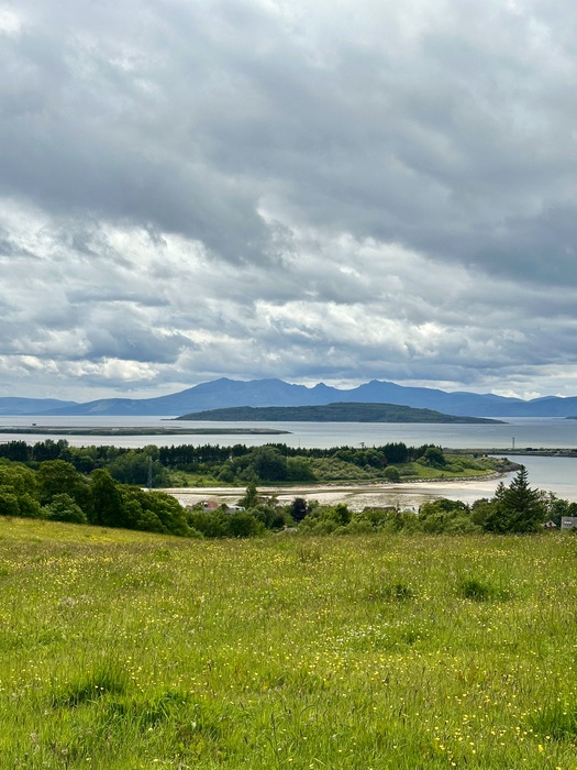
View of Arran from Fields Above Fairlie
Walking through a field full of buttercups with a light breeze on my face, I realise how lucky I am to live in a place like this. It doesn't have the cache of the Highlands and Islands, and is relatively unvisited by tourists. And a good thing too, if you've aver had to trog it up Loch Lomond-side behind painfully slow moving mobile homes. That's not to say we don't get tourists, but just the volume is less. I can often walk up here without meeting anyone, and it's always a pleasurable stroll. From this field, there's a gate, and a simple bridge which takes you across a series of tumbling waterfalls, past Fairlie Castle which is currently being refurbished as a private residence
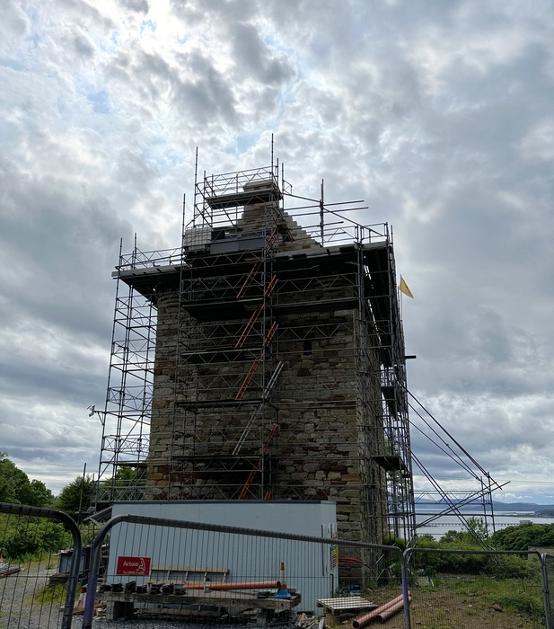
Fairlie Caste, built in 1521
Sir Robert Fairlie of built the present castle in 1521, the family having held the lands since the fourteenth century. In around 1656–1660 the last of the Fairlie family sold the castle and barony to the first Earl of Glasgow. Little Cumbrae Castle, Law Castle at West Kilbride and Fairlie Castle are all in the vicinity of the Firth of Clyde and have striking similarities. I don't know how many people outwith the area even know of the castle's existence, and it's great to have this on your doorstep. More to follow....
23/04/25
A Yomp Up Glen Devon
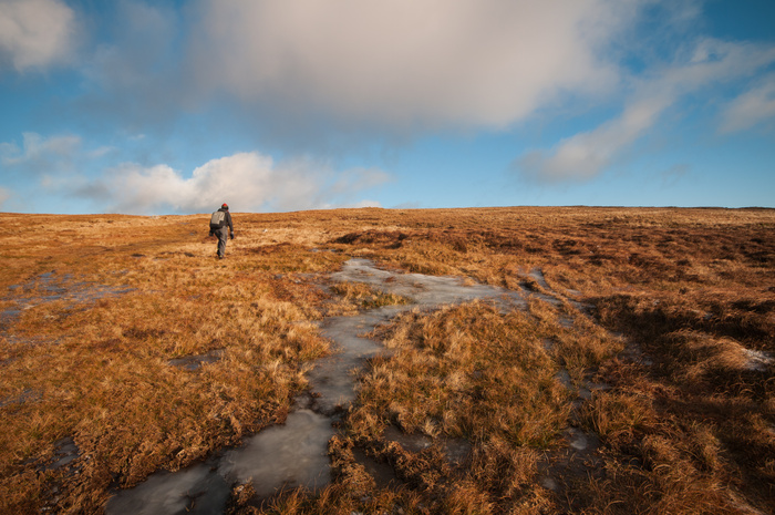
An Easter Weekend walk which should have been up Schiehallion, turned into this 5hr round of high moorland walking. A poor forecast - cloud cover at 900 metres, possible snow and sleet on summit - meant a change of plan. I found this walk on the excellent Walk Highlands website. With no summits higher than about 650m, we'd miss the low cloud. It turned out that the cloud was actually scraping the tops, and the visibility wasn't great for the whole walk. However, once you were clear of the woodlands at Glen Sherup, and up the first summit, it was easy high level walking all the way, to the head of the glen, back round the other side past the minor hill of Ben Shee and back to the reservoir and the start. And all less than an hour's drive from Glasgow!
Looking along Glen Devon
Looking down to Ben Shee
15/04/25
Walk - Old Drove Road, Isle of Skye
You'll struggle to find this walk online. In fact the only walk summary appears to be a You Tube video where the guy goes the wrong way. If you fancy a tough 13k bog-trot with stunning views however, this one might be for you. You should use OS LR 33 for this, and also GPS to actually find the path!
Our Start point was close to the ferry terminal at Kylerhea, where the last turntable ferry service in the world (apparently) operates across the narrow channel to Glenelg on the mainland.
The first kilometre or so is a pleasant stroll along the shore where the path rises below the eastern ridge of Ben Aslak, which we climbed last year. This was the route which crofters and farmers used to drive the cattle from the fertile lands of Sleat to the crossing point at Kylerhea, before the long journey down to the tryst (mart) in Falkirk and beyond. The path, such as it is, is best described as sporting and it took a reading off the GPS to locate it, as it eventually rises to around the 160 metre contour level. It winds up and down over miles of moorland, with constant views across to the mountains of the mainland. Additionally, you'll come across stands of natural birch and alder forest, dotted with streams and wildflowers, beautiful stopping points for tea and biscuits! Eventually you'll reach a path with takes you down to the ruined village of Leitir Fura, and then there is 4k on the track to the car park just off the A851. You'll need to cars for this walk, unless you fancy a 26k walk, or are camping out. A nice alternative might be to do the 9k to Litir Fura, and head back for a few kilometres to one of the birchwoods, and pitch a tent for the night. I'd give this walk 9/10
Old Skye boys on the drove road
11/04/25
Writer Beware!
I recently tried to 'claim' my author page on the Goodreads site. Big mistake! You'd think something like this would be reasonably simple once you'd demonstrated who you were. Wrong! The fact that I don't have an email address on my website seems to have caused a malfunction amongst the administrators, despite the fact that the contact page comes through to my email address. We went around this buoy about five times, with cyclical emails, each from a different admin, asking a series of different questions, but always sticking at this point. Result? No resolution. I still haven't been able to claim my author page, so you can imagine my delight when they sent me a feedback form, which I duly filled in. Result? No response. Ah well, I'll just move on, similar to what I did with Social Media two years ago. Life's a whole lot less stressful.
05/04/25
A really nice evening in the The Edinburgh Bookshop yesterday. It's all that a bookshop should be. Friendly. well-stocked and supportive of local authors. It's located in the Bruntsfield area of the city, with lots of great restaurants and pubs nearby. So, if you're in and around Edinburgh this year, get along there.
02/04/25
You know when you hate getting your photo taken? You can see that here! But what a spot. Halfway through a long walk along an uninhabited section of the Sleat Peninsula in Skye, the sun suddenly broke through dark clouds. Despite wet legs, and a soaking 5 minutes earlier, this wee beach was sublime. Image taken by my fellow walker, Sorley Johnston. A reminder that this scary looking guy is giving a talk at The Edinburgh Bookshopthis Friday, 4th April.
31/03/25
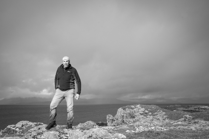
'Man Travels to 42 Remote Islands To Photograph Medieval Castle'. You've got to love Americans! That's the header on a couple of articles which have appeared online last week from news outlets in the US of A. The castle in question is Dunvegan Castle. We used to play in the grounds there as kids, sometimes even scaling the castle walls for a dare. It's located literally a 10 minute bike ride from the house I grew up in. But hey, let's not fact check too deeply. It makes a much better headline that 'Man Travels Ten Minutes to Photograph Medieval Castle', and the 42 islands bit is true...........
On a different Vibe...
Monorail Music on my Music Book!
24/03/25
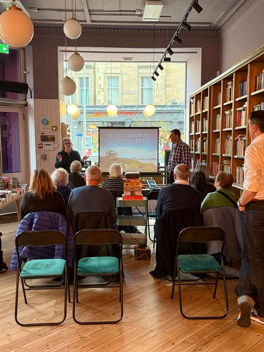
I'm delighted to be giving a talk on 'Scottish West Coast Isles In Photographs' at The Edinburgh Bookshop on Friday 4th April. If you are in Edinburgh on the 4th and want to come along, the link is Here
23/03/25
Two articles about my island hopping in The Scotsman
and The Daily Record
21/03/25
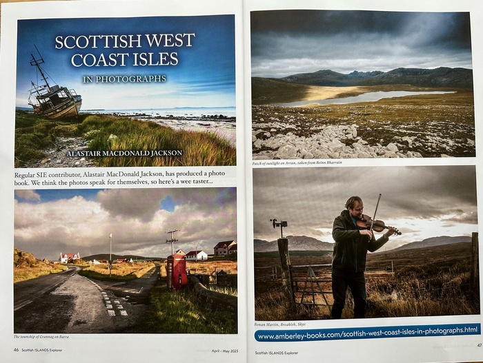
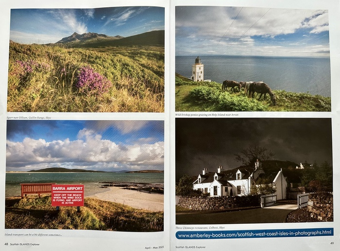
Nice feature in Scottish Islands Explorer Magazine this month
18/02/25
Some book news!
My book, 'Scottish West Coast Isles in Photographs' was published this weekend. Already there is a great review from Undiscovered Scotland who say, 'Wow, just buy it'! Thanks and let's hope so!
My other current book 'Dear Smash Hits, We're From Scotland' has been listed in an end of year Top 10 by Moonbuilding Magazine, edited by ex-Melody Maker writer, Neil Mason, which is excellent news. Post here from Earth Island Books about it
25/11/24
Back to Rum - Waterfall Heaven
Falls below Barkeval
Detail on Falls
Falls on Allt Coire Dubh
A fairly last minute weekend to a wet and windy Rum. That was no problem as waterfalls love rain! Spent a half day just photographing one mountain stream and its attendant falls. Magic..
19/11/24
A Calm Day in the Trossachs
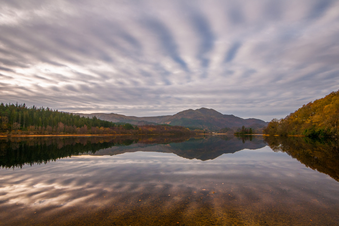
Loch Achray Stripes
A day around the 'mini-southern Highlands' of the Trossachs, which fall almost entirely within the modern district of Stirling, involved a lot of driving along twisting roads, and wading into various lochs in my wellies.
My original intention was to visit 10 lochs, but as usual my ambitions outweighed my capabilities. I managed 7 in the end and managed some decent shots from 4, so maybe that's not too bad an average. The light was very diffuse with virtually no side lighting at all, but the compensatory factor for that was some very still water, and some nice Autumnal colours reflected in the the lochs.
Loch Voil
Also, an extra bonus was it being pretty quiet. As some of this area falls into the Loch Lomond and Trossachs National Park, it gets hugely busy in the Summer. A cold day in Novembe was definitely the time to visit
29/10/24
A Week On Shetland
I had been keeping an eye on the weather for a couple of weeks before I was due to head up to Shetland for six nights. The other consideration uppermost in my mind was that flight versus ferry. The flight was more expensive of course, but the thought of three hours on the train to Aberdeen, followed by a further eleven hours at sea filled me with mounting horror!
So, it was on a wet morning in August that I boarded the Loganair flight to Sumburgh, and was delighted to discover that a complimentary cup of tea and Caramel Wafer was on the agenda. I felt very positive about the day, and it only got better as we touched down ahead of schedule on Britain’s most northerly archipelago. Beig such a small plane, we were quickly disgorged onto the tarmac and twenty minutes later I was in my hire car heading north to Lerwick. I had arranged to meet two friends at a café there, and then we would head north west to Sandness, where we were renting a cottage at the beach for the week.
From distant memories of work visits up here I recalled that the roads were excellent – many had been improved through oil revenue – and relatively tourist free. I’m guessing that it must be extremely expensive to get a camper van on the ferry. One of the friends I was meeting lives on the mainland of Shetland, very close to where we were staying, and in fact is the headteacher at his old primary school in Sandness, so obvious reasons he was designated the excursions planner.
The cottage was in a fantastic location, literally ten seconds walk from the beach, and after we arrived took a stroll along the sands. After dinner and a couple of drams, we decided to take a trip to the island of Muckle Roe the next day, as many Shetlanders regard this circuit to be the finest in the the islands. The forecast was looking good, and we decided to do the walk taking in the lighthouse in the south of the island from Little Ayre. We would pass Muckle Ayre, a secluded red beach, and the Burki Skerries, heading past Muckle Water and Lairds Loch before reaching the coast at South Ham, and following a track back to our starting point. The name Muckle Roe comes from the Old Norse ‘raudoy mikla’, meaning ‘big red isle’. This is because the island is made of red rock from a 350 million-year-old extinct volcano. This red granite is known as granophyre, and its red hue comes from high levels of potassium feldspar. This rock is responsible for the island’s striking coastal features because it resists erosion, and we could sea the water pounding the rocks below the lighthouse, where we stopped for our tea and sandwiches. Sunbathing against a warm slab of granite was heaven!
The following day dawned bright and sunny again, and we took advantage of the weather for a short leg-stretcher along the coast to our friend’s house at Bousta. It was a delightful walk along a grassy clifftop, passing over a sandy beach at Bay of Garth. Beautiful, but unfortunately pretty inaccessible without some abseiling skills. Still, as I peered over the edge with my camera, I took one of my favourite shots of the trip. Hard to believe that the white sands and aqua waters weren’t on some tropical island.
Every day was packed with activity, so it was south again the next morning to pick up some messages in Lerwick and visit St. Ninian’s isle which is connected by the largest tombolo in the UK on the south-western coast of the Mainland. The island has ecclesiastical connections, which may, like others in the Northern Isles, Hebrides and Faroes have connections to the Culdees or Papar (Irish monks who took up solitary residence). However, the island's history is far older than Christianity, and Neolithic graves have been found within the walls of the chapel. In 1958, an excavation found a hoard of 8th century silver in the chapel grounds under a stone slab in a wooden box, which caused a renewed archaeological interest in the island. It was suspected to have been buried to hide it from, or stolen in, a Viking raid. Fortunately, when we crossed the sand that day, there was nothing as exciting going on. Just some folk paddling in the water, and somebody flying a kite. We then headed further south to meet the puffins at Sumburgh Head where cliffs meet the North Sea, while the historic lighthouse watches out from the top of the cliffs. During the summer, Sumburgh Head comes alive with the spectacle of thousands of seabirds, including Puffins, Fulmars, Guillemots and Shags, and I was quite surprised at how nonchalant the puffins were as people pointed cameras and phones at them. They looked like they’d seen it all before.
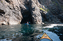
Given the fact that the weather was so good, it was fitting that our final two days on the islands were to be spent kayaking around the NW coast, exploring the numerous caves and sea stacks. I have to confess at this point to never really having kayaked before, so I was slightly nervous about tipping myself out in the cold water. But I needn’t have worried. Apparently, these sea kayaks had a buoyancy aid in them, so as long as I wasn’t too hopeless, I should be able to manoeuvre myself through the water. During the first session, we went out for about three hours, circling around rock stacks, whilst nosy grey seals kept a quizzical eye on us. On our last day, we ventured out a bit further from the Voe of Dale into Whal Geo, and its sea cave. A Geo is an inlet, a gully or a narrow and deep cleft in the face of a cliff, and are common on the coastline of Shetland and Orkney. It was quite a serene experience paddling through the cave with the sun slanting in on the walls. The return journey was slightly less so, battling into incoming tide with a side wind for good measure. At one point I really felt that I was just paddling to stay still, but as we rounded the headland, the wind dropped, and we were able to drift back in on the tide. Once we secured the kayaks back onto the roof of the van we sat and enjoyed the afternoon sun on the shore. A fantastic end to an unforgettable trip.
08/10/24
Back To The Eigg (or Eigg at any rate).
Article published in Oct/Nov issue of Scottish Islands Explorer Magazine
There’s always a risk when travelling to any island in February that it’s going to be wet and windy. On my two previous visits to Eigg, it didn’t disappoint, with storms and sunshine in between. This trip was to be much the same on this trip, although thankfully without the terrible ferry crossing on the way over.
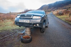
There is something really lovely about returning to a place that you enjoy exploring and things that seemed perhaps slightly odd, now seem just to be part of life there. Although the car propped up on a beer keg in a passing place could probably only have been something that would happen on Eigg. I found out later who had done it, and they somewhat sheepishly admitted that they had jacked it up with the tractor to allow their neighbour to inspect the undercarriage of the vehicle. I don’t think Health and Safety would have approved!
The forecast was mixed, as I’ve alluded to above, so we decided to make the most of it by getting out about on a couple of weeks which I hadn’t done. We decide to park down at Kildonan farm and pay a visit to the cemetery where my friend Mark’s relatives are buried. Also located there are the ruins of a chapel and Crois Mhor (large stone cross). St Donan's Church is said to have been erected by John Moydartach, Captain of Clanranald in the 16th c. The 14th century cross-shaft is mounted on a modern base on a rise to the S of the church. A dig back in 2012 established that St. Donnan, who bought Christianity to Eigg in the 7th C, had founded a ‘muinntir’, a small monastic community on the fertile sloping land near Poll nam Partan on the south east side of Eigg. The church Donnan had built for his muinntir gave its name to that part of the island ‘Cill Donnan’, or Donnan’s Church in English.
From there we headed up through the fields on the cliff edge, intending to walk up to the top of Beinn Buidhe. However, once the rough grazing land petered we found ourselves knee deep in heather and bog, so we decided to cut the walk short and headed back to the cemetery where the light was raking the stone walls, turning everything a honeyed colour - perfect photography conditions.
As predicted the next two days saw the island lashed by storms, and there was little or no point in heading out walking. Luckily there was a supply of books in the house, and when Mark popped over the field to see his uncle and aunt, I was happy enough to stretch out with a mug of coffee and some literature.
The weather brightened up considerably on our last full day and we decided to head down to the ‘Massacre Caves’, which we didn’t have time to visit the last time I was here. The Spring of 1577 was a particularly dark period in the Isle of Eigg’s turbulent history. The island’s entire population sought refuge in a hidden cave on the south coast, taking cover from the MacLeods of Skye who had just landed on Eigg during a clan feud between themselves and the MacDonalds. Apparently, the MacDonald’s had broken each and every limb of the MacLeod Chief’s first-born son before discarding him in a boat, devoid of oars and bound to perish at a glacial pace. The vengeful MacLeod’s returned to Eigg. But after searching in vain for three days amidst snow and freezing temperatures, they Ma departed to return to Skye. Just as the islanders seemed safe, the MacLeods spotted a lookout. Returning to Eigg they followed his tracks through the snow to discover the cave, lighting a fire at the entrance. Trapped, nearly 400 islands were suffocated inside the cave by the smoke. The gruesome history of the place continued with Victorian tourists would take pieces as souvenirs, before islanders insisted that the bones were buried. I was quite glad to get away from the place……..
So, it was back to the mainland the next day, with the inevitable ferry shambles, and I can’t wait to do it all again in February.
30/09/34
Great Review for my DIY music book on Thoughts Words Action Blog. I believe it has now sold over half of its first pressing, so if you would like a copy it's available from Earth Island Books
29/09/24
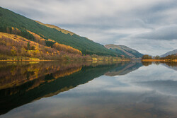
Took an afternoon last week to head across to Argyll. I knew that the weather was going to be good. Breezy, intermittent sunshine, and nice low light by the late afternoon. I'd wanted to stop at Loch Restil at the top of the 'Rest and Be Thankful' road on the A83 for a long, time, and I finally got around to it. Just a short wander from the cat park allows you to get a nice perspective looking over the loch to the head of Glen Croe
09/09/24
Spent a week up in Shetland in July. Below is an image looking down on the Bay of Garth on the Shetland mainlaind
Fantastic weather, and a fantastic place, ideal for walkers, photographers & kayakers. And I did all three! Kayaking for the first time (see below) around sea-stacks, and in and out of sea caves - amazing!
16/08/24
Book is Staff Pick at Monorail Music!
03/08/24
New non-photography book launched!

Featuring new interviews with members of The Rezillos, The Pastels, Echo & The Bunnymen, The Slits, The Bluebells, Strawberry Switchblade, Shop Assistants, Bis, The Mission, BMX Bandits, Soup Dragons, Pictish Trail, Fizzbombs, the Vaselines, Rote Kapelle, Close Lobsters & Urusei Yatsura, as well as cassette label owners and zine editors of Bam Balam, Ripped & Torn, Slow Dazzle, Juniper Beri-Beri, The Next Big Thing, Honey At The Core, Heavy Flow, Paper Bullets and more……..
Available here
and here
24/05/24
As I plan for my Shetland trip in July, a wee look back to earlier in the year on Eigg
As well as stunning scenery, Eigg boasts a fine selection of scrap & nearly scrap cars. This beauty on a beer keg was seen at Cleadale. No Health & Assessment on this one I fear.....
16/05/24
Today's blog - a bit late, but here are some pages from my feature in the print edition of Scottish Field Magazine
15/05/24
More book news! I've been commissioned by Amberley Books to publish a photography book on Orkney & Shetland, so I'll be heading to the far north in July to make a start....can't wait!
15/05/24
In case you missed in on the front page, I have a release date for my book Scottish West Coast Isles in Photographs of 15th March 2025. Don't where the launch will be...maybe Oban. I'll keep you posted
10/09/23
This you tube video has racked up about 10k views a year. It features images of mine in B&W, many of which appeared in the 'Spirit of the Hebrides' book.
01/09/23
Walking Scotland in Miniature
Since moving to North Ayrshire in 2009, I've visited Arran a good number of times & each time have discovered something new and interesting about the place. Not for nothing is it referred to as 'Scotland in Miniature', with the northern part of the island being the mountainous 'highlands', and the more rolling southern part, the 'lowlands'. It's a popular destination for Glaswegians and Ayrshire folk, and from those further afield, as the train runs right up to the ferry terminal in Ardrossan, and that makes it ideal for both day trips and longer stays. In particular, it offers some of the best island hillwalking outwith Skye. I'm going to stick my neck out here and say that whilst Mull, Rum, and Harris, in particular, have fantastic hills, only the A'Chir Ridge in Arran is on a par with the Skye Cullin for exciting ridge walking.
On a decent day, a walk up the 874m (2,867ft) peak of Goat Fell is popular, and provides a fantastic panorama, as far as the hills of Northern Ireland. I've been up to the summit twice, in March and May, and both times it's been shorts and t-shirt weather. It certainly makes up for the many, many days of rain on the Scottish hills! You can walk the hill from the ferry terminal, but it's quite a long day, as you're adding on around 3.5km to get to the starting point at Cladach. From there, it's about another 4km (2hrs 20min) to the summit. If you're feeling fit, you can choose to traverse the whole of the north ridge to Sannox, but this is a route for more experienced hillwalkers, and is a challenging expedition.
Another hill which I've walked twice is Beinn Bharainn, the highest of the western group of hills at 721m (2,365ft). It's far less visited than its eastern neighbours, but it's a fine hill in it's own right, and provides fine views to the west, where the Paps of Jura, and the lower hills of Islay, are clearly visible. Whilst it cannot rival the grandeur of the eastern hills, it has a quiet charm of its own, and offers a peaceful sense of isolation. There are two ways to walk Beinn Bharrain. The quickest way is from Pirnmill on the western shore of the island, and you can be on the summit in under two and a half hours. The longer route will take you up Glen Catacol, and up to lonely Loch Tanna, which sits high up in deer country. The first time I walked it, we tackled it from Pirnmill, and then dropped down the other side of the hill to Loch Tanna, where we camped for the night. It was midge hell that evening, and thankfully the tent was double skinned, and prevented the wee swines from getting inside!
The next day we decided we were going to tackle Beinn Tarsuinn and the a'Chir Ridge by heading east across boggy moorland, through Glen Iorsa, a 5km slog, which of course, we were going to have to complete in reverse! Of course we decide to tackle the ridge directly, which the Scottish Mountaineering Clube guide notes that 'its traverse is only for those with rock climbing ability' (or those stupid enough to give it a go). Needless to say, we managed it, or I wouldn't be wroting this, but noted that there were climbers with ropes on the ridge, and we tried to breeze nonchalantly past as if we were out for a stroll in the park. Despite the potential dangers of falling to our deaths, it was a fantastic day out, and the 360 degree sea views were breathtaking. My second ascent of Beinn Bharrain, was slightly less eventful- at least until it was time ro head down. My climbing companion and I had been watching with fascination as a helicopter rescue, or perhaps just an exercise was taking place on the opposite hill. We hoped it was an exercise, rather than the real thing. Anyway, time passed, and we thought we should set off back down Glen Catacol towards the car, realising that we were now going to cut it fine for the ferry. Alex did his level best to speed his way down the A841, only to see the ferry pulling out of Brodick pier. It was going to be along wait for the next one, as that was the final ferry of the day, and a night on Alex's sofa beckoned!
I have been back to Arran several times since, and enjoyed some rather more sedate walking, and we had planned to visit Holy Island, but were prevented by poor weather. Without a doubt, it's a great place to visit, and whatever your walking ambitions, you won't be disappointed by what Arran has to offer.
19/08/23
Walking the North Skye Coast – Part 4: Kensaleyre to Camustianavaig
In Part 3 of this article, we followed a coastal route from Dunvegan to Kensaleyre. In this part we'll follow the coast as much as possible around the Trotternish Peninsula, a great wing jutting out to Skye's most northerly point of Rubha Huinish. We'll head back down the coast to Portree, and finish with a glorious hillwalk of Ben Tianavaig south of the island's capital.
All in all this route is about 60 miles (97km) long, so as with previous routes I would recommend only walking the best sections, and I'll point these out as we move through the journey. For many people, the only viable mode of transport might be by car, but fortunately there are many elevated sections, so views are stunning however you do it.
An alternative to following the coast is to take the Trotternish high level route, a 26 mile (42 km) walk across the spine of the peninsula. I've walked part of this route from its high point of The Storr (2358ft/719m) over several tops to the bealach where the Quirang car park is situated. You are flanked by the sea on both sides, and as you get further north, on 3 sides. On a clear day, stunning views of Raasay, Rona and the Outer Islands are almost too much to take in. However, this route is only for the fittest of hillwalkers, but for those who feell up to it, it does offer a viable and exciting alternative route along the peninsula.
Anyway, back to the coastal route. It's about 9 miles from Kensaleyre to Uig along the A856, and I would recommend missing out this section of the coast. It's frustatingly boggy in places, and involves negotiating the River Hinnisdal and a number of barbed wire fences. Instead, enjoy a pleasant drive to the high point above Uig bay, where some good shots can be taken of the village and the pier where the ferry leaves for Tarbert and Lochmaddy. Continue through the village and take the turn onto the A855. In order to save your legs, follow the road up over the hairpin bend and past the right turn for the Quirang. About a kilometre past this there is a viewpoint and carpark on the left. Park here and enjoy the views. At this point you have two choices. You can either go back along the road for a half-kilometre, and follow a minor road down to Scuddaborg where you can pick up the coast to Kilmuir. Again, what you might look like a pleasant low level coastal is quite boggy and wet, although if you stick rigidly with the shoreline it is a bit easier. The alternative is to walk the 9km from the viewpoint to Duntulm Castle along the single track A855. Even at the height of the tourist season it's not that busy, and is a much more interesting route, as it is fairly elevated and the views out to the hills of Harris and Lewis are fantastic on a clear day. It also takes you through the crofting townships of Linicro, Balgown, Kilvaxter and Kilmuir. The north end of Skye is somewhat of a Gaelic stronghold, and this may be something to do with the fact that it is one of the most fertile parts of the island, with many large crofts where crops are still grown, and healthy cattle graze. The last couple of kilometres of road to Duntulm Castle is a roller coaster of cliffs, hills and crashing waves below, and you'll find it hard to keep your camera or your phone in your pocket here.
Whether you've driven or walked this far, the coast from Duntulm to Rubha Huinish is definitely a must. The short leg stretch to Duntulm Castle gives far reaching views out to sea and the small group of Skerries of An t-Iasgair, An Dubh Sgeir and Sgeir na Ruideag (The Fisherman, the Black Skerry & the Kittiwake Skerry). The castle istself is unfortunately in a ruinous state and closed off to the public. It was originally a Pictish fortress which was seized by the Vikings and held by them until they lost control of the islands in 1263. Incidentally, you can tell by the township names that this part of Skye was very much a Viking stronghold. The first mention of a MacDonald chief occupying the castle was from about 1616 when Donald Gorm (Blue Donald) set about improving it, before it was abandoned around 1730. Once you've enjoyed the views, head back to the road for a short walk to the Duntulm Hotel, which must surely enjoy one of the best views in the Hebrides, overlooking Tulm Bay and Tulm Island. I had suggested to my wife that we might pop in for a coffee during our walk, so it was something of a shock to see it was closed and run down looking inside. No chance of a coffee then! When I asked my cousin in Dunvegan ( a builder and font of all local knowledge) what the story was, he was a surprised as me to learn that it was closed and sadly forlorn. However, a subsequent check on Google looks like it has been sold at a reduced price, and hopefully is going to be refurbished soon. Maybe we'll get our coffee yet. From the hotel, take the track onto the shore and follow a path round Tulm Bay. We were super fortunate with the weather, and the stroll around to Meall Tuath was a delight. There is a gate at the bottom of a hill through purple heather and bees, and an easy incline of 100m or so takes you to a small headland where you can gaze down at the aqua waters of Loch Hunish and the peninsula of Rubha Hunish. From here, a short drop and incline to the former Coastguard lookout takes you to an obvious cleft in the hillside to quite a precarious path down the cliffs towards the point. If you venture down onto the peninsula, you'll find an almost lost world quality to the place, with the calling of hundreds of seabirds, and the perfect sea stack of Bodha Hunish, one of the best in Skye. It is well worth continuing round the coast from the lookout emerging back on the road to the east of Balmaqueen township.
The road follows a line close the sea for the next 8 kilometres, so it's worth staying on this for a while, although there are plenty of interesting diversions if you want to stick right on the shoreline. The escarpment of the Trotternish Ridge and the convoluted geology of the Quirang become increasing close on your right as you head through the townships of Flodigarry, Dunans, Digg and Glashvin, and as you come into Brogaig, you'll see the Quirang road on your right. It's well worth taking the 3km diversion to the Quirang car park, although you probably want to take half a day to explore the area properly. You'll also be rewarded with a great view of Staffin Bay & Island.
Once back on the main road, you'll find that it has become a much faster double carriageway, and driving the next section from here to the Storr Lochs Power Station might not be a bad idea, although there are a number of viewpoints and walks which you will want to stop for – Kilt Rock, Rubha nam Brathairean and Lealt Falls to name a few. The 11km walk from the power station to Portree is one of the lesser known walks in Skye, but for that reason alone it's worth doing, as it's lovely and quiet. I've been along this section of coast twice, and I've not met a soul. From the A855 a minor access road takes you down to the power station, and a walk down its 647 steps is a must do. Commissioned in 1952, the Storr Lochs power plant generated 8GW of electricity a year, transforming the lives of folks on Skye, and it has recently been refurbished in 2017 with new turbines and an automated system to support it for a further 25 years. Once you've finished looking around the scenery at Bearraraig Bay, head back up the steps, and follow the coastline south above Holm Island. Following this route will take you on an excellent 11km clifftop hike all the way to Portree, and on a clear day the sea views are superb. Stay on steep ground below the split-level cliff at Fuirnean (349m), and about 2km further south cut up an obvious gap in the cliffs and on to the summit of Craig Ulatota, where you can rest at the 392m trig point. To the east Raasay and Rona lie alongside, and to the south, the profile of Ben Tianavaig rises up beyond Portree, and the Red Hills of the Cullin frame the horizon – quite a windswept and stunning viewpoint, and somewhere that I certainly stopped to get some images of the brooding skies and mountain vista. From here it's a steady descent round into Loch Portree and the bright lights of the island's capital.
The final section of the north Skye round, and a fine walk in it's own right, starts about 4km SE of Portree at the township of Penifiler. From here you can cut across the moor to Camas Ban, where you can follow a good path over craggy ground, following the shoreline west, until you reached a point directly below the summit of Ben Tianavaig. The going is easy on short turf, and you'll soon get to the 413m summit which offers more stunning views. From here, follow the ridge line down to the settlement of Camustianavaig where you can follow the B883 back to Penifiler. This is a fitting end to the long and arduous circuit of the north Skye coastline walk. I can guarantee that if you buy a copy of of the OS Landranger 23 Map and open it anywhere, you will find a walk that whets your appetite. And perhaps, you too will end up with a copy as battered and bruised as mine, as you keep coming back for more!
27/07/23

Walking the North Skye Coast – Part 3: Dunvegan to Kensaleyre
In the previous section, I took you round the South Duirinish coast and over the highest sea-cliff on Skye, finishing up in the village of Dunvegan. In this section, we'll pass sights such as Dunvegan Castle, Coral Beach, the village of Stein, and Trumpan Church, the scene of a gruesome massacre and battle. This is a section of one large peninsula (Waternish), and many small ones. More than any other section so far, this walk can be split in to a number of intermediate or short ones, and takes in the usual variety of North Skye scenery such as cliffs, crofting villages, woodland and small islands. With the notable exception of the Coral beach walk, you can expect to meet very few people once you are away from the main settlements.
Dunvegan is one of the main tourist villages in Skye, with shops, hotels and of course the castle, home to the Clan MacLeod. Apart from anything else, it's a good base for the North West of the island, and you can plan day walks or expeditions from here. It's only a kilometre or so from the village along to the castle, and once past that the road turns to single track. It's a measure of how the place, and society in general has changed, that on the day of Dame Flora MacLeod's funeral, we were hauled out of primary school and made to attend her funeral! Still, if you were local, you used to get into the castle for free, and that doesn't appear to happen now. Of course, when we were kids, we used to scale the walls just for fun, and then nonchalantly walk back out through the entrance.
Anyway, on with the walk. The road stays close to the coast, past Loch Suardal, and along another 3km of pleasantly rolling countryside. As you come into the township of Claigan, there are a couple of new houses and some of ubiqutous 'pods', or garden sheds as my wife likes to call them, which have fantastic views over Loch Dunvegan. I've always wondered what pods are like to stay in. They're certainly not a cheap option for holidaying in Skye, so I hope they are comfortable at the least. Almost every drive and house entrance has a 'No Parking' sign, which seems a bit unfriendly, but once you reach the chaos of the car park, you'll understand just how busy it gets down here, especially in the Summer. Still, it is very much worth it, and I would recommend as a stand alone walk, to come down here in the late evening, once the crowds have disappeared, and the light is playing off the sands and the small offshore island of Lampay. If you are walking this as part of a longer route, continue to the headland of Groban na Sgeire, and yiu'll see the island of Isay in front of you. This island was populated well into the 19th Century, with it's own general store, but was subject to the horrendous greed of the landlords, and cleared in 1880 to make way for sheep. It was briefly owned by the Bob Dylan copyist, Donovan, in the 1960s. More of him later.
From here the route takes you along a steeply slopung foreshore, through scrubby woodland and round to the curving sweep of Loch Bay, and its small settlement. This is the start of the Waternish Peninsula, and it's probably easier to head ip the minor road onto the B886, and for the next 3km or so, you can enjoy elevated views across the bay and down to the planned fishing village of Stein below. In 1790, the British Fisheries Society planned a fishing port to be designed by Thomas Telford. However, poor management of the project, and the lack of enthusiasm shown by the local crofting population for fishing, meant only a small proportion of the scheme was constructed. By 1837 the Society had made a loss of £3,000 and seven years later it sold off the land it had acquired. Only a few structures were completed to Telford's design, including a pier of 1796–1802, and the Stein Inn (1790). If you look just along the shore from here, you'll see a large house, which used to belong to that man Donovan again. He had a short sojourn here with his manager and a group of followers who attempted to set up a commune, and also apparently owned the island of Clett nearby. For the next 5km to Trumpan, I would recommend heading back onto the road where you can enjoy those seaviews again. Trumpan church was the scene of another massacre and battle in 1578, this time between the MacDonalds and the MacLeods, with the MacDonalds coming off second best. From the church the road heads downhill, and just as it starts to loop back on itself, there is a gate with a track leading off. This is the start of the 6km walk to Waternish Point. I've done this walk several times, and I'm not sure if I've actually met anyone on it. It doesn't have the cliffs of the Duirinish Peninsula or the hills of the Trotternish Peninsula, but it has a remote charm of its own, and there are a couple of brochs to look at if time allows. Once you reach the ruined farmhouse at Unish it's a straightforward tramp to the unmanned lighthouse at the point. It was here that 'Bonny' Prince Charlie and Flora MacDonald first landed in Skye after crossing from Uist in 1746. Their visit was shortlived however, as they were challeged by two MacLeod sentries, and had to turn round and head for Kilbride Point on the Trotternish Penisula instead. For the first 5km there is a good cart track, although a bit boggy in places, and just before you reach the ruins of Unish, you should bear left and follow the coast down to the lighthouse. The last time I was down there I watched the ferry heading back from the Outer Isles back towards Uig.The continuation of the coast takes you past Creag an Fhithich (Crag of the Raven) and along towards the sea stack of Caisteal an Fhithich (The Ravens Castle), all the way affording excellent views over towards the Trotternish Peninsula. A couple of km over tussocky ground takes you back onto the road through the townships of Geary and Knockbreck to high ground above Loch Losait. I would advise most walkers at this point to to follow the road back past Knockbreck Primary School and back to Trumpan, or the hill track to Brae Stein depending on your start point. The next part of the walk will take you onto the Greshornish Peninsula, better tackled as an indivual walk, as the 9 km or so from Loch Losait is a real slog over vegetated cliffs, rough boggy moorland, bracken and crags. The day I did it, it was raining and pretty miserable and realistically, the effort probably outweighed the reward, although there is an interesting natural arch above Gob Uisgebrigh.
Assuming then that you've taken the minor road and driven to Greshornish House Hotel, a cart track takes you to Loch Diabuig, and back to the coast walk. I've seen a couple of writers being dismissive about the Greshornish Peninsula, and that's a good thing in my book as it keeps the day trippers away! In the three or four times I've walked the peninsula, I've only met other walkers once, and I've taken one of my favourite images there, as an approaching storm threatened to soak me. There are a number of sea stacks, and the cliffs rise to 97m (319ft), before falling away again towards the point. A short walk takes you back round to the Hotel,and either your car or the continuation of the walk around towards Edinbane.
The next stretch from Edinbane to Kensalyre is around 16km, and like most roads in Skye, follows a roughish line around the coast, with the major exception being the finger of land which juts out to Lyndale Point. Again, this is probably a section of the coast for those detemined to complete the whole north Skye coast walk, but it has some lovely short individual walks along it. The Kildonan and Fanks loop road meanders through a couple of townships with peaceful views back down Loch Geeshornish. When I was walking this section earlier this year, I ended up chatting to Billy MacRae, who farms the land at Lyndale close by, and was a few years above me in school. He advised me to follow a farm track to the beach at Camus Mor, where I could follow the coast around to Lyndale Point. It was good advice, as the views out to Eilean Mor and the Uists were stunning. The other worthwhile stopping off point is close to the finish at Skeabost, where the Snizort River is about to head into Loch Snizort Beag. Imagine growing up somewhere like Skye and having no clue about the existence of a river island?! I suppose it’s not so surprising given the number of offshore islands, but I was not aware that there are also onshore (river islands) of which St.Columba’s Isle (Eilean Cholum Chille) is one. Just below the bridge where the main road between Portree and Dunvegan crosses the River Snizort, , there is a well hidden and fascinating bit of Skye's history - St. Columba's Isle St. Columba is much better known for his association with the island of Iona, but this the site at Snizort was where he founded the cathedral of the Bishops of the Isles. This was the centre of Christianity in the Hebrides from 1079 to 1498. The first chapel here was founded in the 6th century by St Columba (521-97) whilst visiting Pictish settlements, and probably after founding his famous monastery at Iona (563 AD).
It’s a very short walk to the island from the old Skeabost bridge (I wondered if my school bus ever went over that, or perhaps it was bypassed by then) and then across a footbridge built in 1990 by the Royal Engineers in conjunction with Heriot Watt University. The island itself is a fascinating wee jumble of gravestones and ruins. I have to say that it doesn’t feel like being on an island, but it does feel secluded with a real sense of ancient history about the place. Even though the chapel is ruinous, there are very few buildings in Skye older than the 1700s (a combination of zealous reformers destroying Catholic churches; plundering stones for building and destructive weather), so it is fairly unusual to be surrounded by antiquities, and I hang around until the rain turns really heavy, and sends me scrabbling for my waterproof jacket.
From here it's a few few short kilometres round to Skernish Point and Kensalyre, where we are are going to finish this part of the north Skye walk, before embarking on possibly the best section – round the Trotternish Peninsula.
20/07/2023
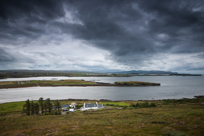
WALKING THE NORTH SKYE COAST – Part Two..The Maidens to Dunvegan
(This article was first published in Scottish Islands Explorer Magazine in August 2021)
In Part 1 of this walk around the coast of North Skye we finished at the sea stacks known as MacLeod's Maidens. For this section of the walk we'll continue along the South Duirinish coastline, past Neist Point, on to Biod an Adhair (the highest cliff on the island), and back down the east of the peninsula down to Dunvegan.
The 15km cliff top walk which continues from the Maidens to Ramasaig has been described by the excellent climber & writer, Ralph Storer, as the finest cliff top coast walk in the British Isles, and I for one would not argue with his assessment! If you plan to continue your trek along this section, you have several options open to you. Because you will have already walked from Bharcasaig by this point, the total distance until you reach the shepherds cottage, and road end, at Ramasaig is 22km. Unless you plan to camp along the way, or stay in the bothy at Glen Ollisdale, you will need someone to pick you up at Ramasaig. Additionally, I was along the road recently, and it was in a very bad state of repair indeed, so that is something to watch out for.
After you leave the Maidens you will climb above Inbhir a'Gharraidh bay, and down to a small headland where you will actually get the best view of the stacks. From there looking north, you can see the route stretching out temptingly. The path, which is intermittent, takes you over fantastic scenery, rollercoastering through Glens Lorgisdal, Ollisdal and Dibidal. However, it's the next section which is the most spectacular and I would recommend that you keep back from the cliff, as the edge is quite crumbly. If you are a photographer who likes cliffs and rough seas, this is paradise!
After about 5km you will cross the Lorgill River which takes you into the glen with the ruins of the clearance village of Lorgill. In 1830, the inhabitants of Lorgill were read the following statement by the sheriff officer:
‘To all the crofters in Lorgill. Take notice that you are hereby duly warned that you all be ready to leave Lorgill at twelve o’clock on the 4th August next with all your baggage but no stock and proceed to Loch Snizort, where you will board the ship Midlothian (Captain Morrison) that will take you to Nova-Scotia, where you are to receive a free grant of land from Her Majesty’s Government. Take further notice that any crofter disobeying this order will be immediately arrested and taken to prison. All persons over seventy years of age and who have no relatives to look after them will be taken care of in the County Poorhouse. This order is final and no appeal to the Government will be considered. God Save the Queen.’
It's a very poignant spot and you will want to take a moment and reflect on the the events which happened here, and in many other places in Skye.
From here you can follow the track up to Ramasaig, but a more interesting route is to climb above Lorgill Bay to the high point of The Hoe (233m). From here you will get fantastic views back along south to the Maidens and north towards Ramasaig Cliff. As you descend towards Ramasaig Bay, you will see the Estate/Shepherds Cottage, and you can cut across the fields to end your walk at this point. I have fond memories of fishing for mackerel at Ramasaig when I was young, and I remember being carried on my Dad's shoulders when we nearly got cut off by the incoming tide!
From Ramasaig to Waterstein it's a wonderful couple of kilometres of up and down walking on short turf which takes you to the highest point of the South Duirish coast walk. Waterstein Head is a dizzying 296 metre high perch above the waves at Moonen Bay. If you are brave, you can peer down and see the breakers on the rocks, but you may just want to look back south and see the line of cliffs which you have just walked along. Looking north, you can see Neist Point, and the lighthouse, where you will probably meet the first crowds on the whole walk. Both times which I have walked the South Durinish coastline, I struggle to remember whether I actually met anyone, so you are probably in for a shock at Neist, especially if you have walked it in the Summer months.
From Waterstein Head, it's a nice easy wander down grassy slopes following edge of the escarpment, down to the road north of Loch Mor, where you reach the car park at the start of the lighthouse walk. As I have mentioned, it can get incredibly busy here in the Summer, to the extent that the vehicle recovery truck from Portree has refused to come down here, after being stuck for two hours in traffic along the single track road. It is worth a detour to see the lighthouse constructed in 1909, now fully automated, but if like me you are crowd-phobic, you probably want to carry on round the cliff edge across Mointeach nan Tarbh (the Moor of the Bull). This will take you up over Oisgill Bay and round to the pier at Meanish, where you will finally reach the townships which make up Glendale.
This is a natural break point in the walk,and the next section, to Biod an Athair, is a nice 10 km there and back walk from the old watermill at Pollosgan. The day that I chose to do this particular section of the walk was a muggy, airless day in August, at the height of the midge biting season! This meant I had to stick to a route only inches from the cliff edge to try and get the slighest puff of wind, and if I stopped for more than 10 seconds, they were all over me, my camera lens, bag, everything! People often say to me, but you grew up in Skye, should be used to them. Unfortunately it doesn't quite work like that. However, the trek to the top of Biod and Athair (313m/1029ft) is absolutely worth it. The views across the Minch are spectacular, with North Uist, Benbecula & South Uist stretching across the horizon of perfect blue sea.
From here the coast descends pleasantly towards Dunvegan Head, and on to Am Famhair (The Giant), a narural arch on the opposite side of the peninsula. The terrain becomes increasingly boggy and choked with bracken as you head for Galtrigall and the start of the road again. Never more that ½ km from the sea, the road winds pleasantly along its 8km towards Skinidin. On the way it passes the memorial to the MacCrimmons , pipers to the MacLeod's, and the famous 3 Chimneys Restaurant at Colbost (where yours truly once waitered and washed pots!).
Just past Colbost you enter the small, scattered township of Skinidin, where my Mum was born, and as you come out the other side, you leave the road to divert around the stubby headland of Uiginish. The last time I was here, I disturbed about 20 grey seals basking in the sun, and as I walked past where they had been lying, they popped their heads out of the water to check what had got in the way of their sunbathing. This section of the walk follows low cliffs our to the small, unmanned lighthouse at Uiginish Point, and then round to the farm houses, which afford a fine view of Dunvegan and its castle. Once the road is reached, you can follow that to the B8884 for a further 1km, before branching left again on a minor road for the couple of kilometres to Dunvegan.
Personally, the Duirinsh peninsula, and the NW corner of Skye in general is my favourite part of the island, but I know I'm biased. It is surprising however, how few visitors get beyond Dunvegan Castle, The 3 Chimneys or Neist Point. There is so much to to explore here, whether it is short walks, day treks, or overnight expeditions, there is something to suit every kind of walker.
13/07/23
Back Again!
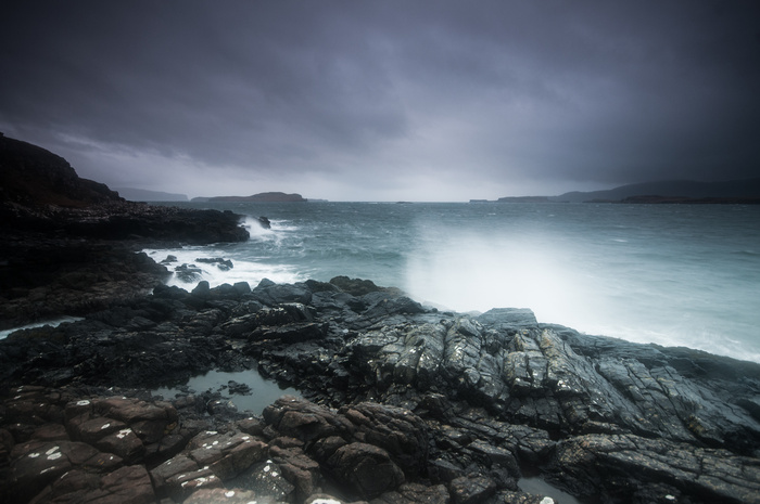
Storm at Loch Caroy, Skye.
I've been documenting my travels through the islands in Scottish Islands Explorer Mag and so I thought I would post up the articles here, starting with a walking trip through North West Skye...........
Walking the North Skye Coast – Section 1 (Gesto Bay to MacLeod's Maidens)
It was never my original intention to turn this into a walking or photography project. For almost as long as I can remember, parts of this coastline have been an integral part of my life. As a youngster growing up in Dunvegan in North West Skye, it was hard to avoid this part of the coast. We went fishing to Neist and Ramasaig, picked whelks at Skinidin and I recall at least once going with the family to Oisgill Bay so that my Gran could collect Carrageen (a kind of seaweed used to make what I always thought was an unappetising gelatinous pudding!).
As an adult I had walked round the south Duirinish coastline, out to Waternish & Greshornish points, latterly with a camera in hand, hoping to capture some moody wave and weather action, so I had notched up a fair few miles when I hit on the idea of covering the entire coastline as set out on my trusty Ordnance Survey Landranger 23 map. This runs from a non-specified point on Loch Harport, northwest up the Bracadale shores up to Roskhill and then to Idrigill on the South Westerly edge of the map. It the runs northwest again over the uninhabited lands of south Duirinish, along what Ralph Storer describes as the finest cliff top walk in the British Isles;awesome and breathtaking. From the clearance township of Lorgill over the stunning vantage point of Waterstein Head, around the tourist honeypot of Neist Point past Oisgill Bay and finishing up at the Old Watermill in Glendale.
As this section represents something in excess of 65kms of rough (mostly trackless) walking, I'm going to take you on a visual journey split into a number of smaller sections - many which can be done over several shorter walks -all of which give a grand sense of space and remoteness.
The journey begins on the edge of Harport, roughly at Gesto Bay, and up and west of the village of Struan (insert struan reflections image) towards Uillinish Point, where you can walk across to the tidal island of Oronsay across a nice causeway of rounded stones. (insert causeway image) The most usual route is from minor road end near Uillinish, a mere kilometre over a muddy path, or a gentle four kilometre hike from Struan Jetty to Uilllinish Point. Once across to the island (having checked tide times beforehand of course), you can make a pleasant circuit of the island, taking in the views of the other islands in Loch Bracadale and the distant hills, Healabhal Mhor & Healabhal Bheag (MacLeod's Tables) away to the NW. and the Bracadale cliffs SW.
Heading back to Uillinish, the coast heads past the townships of Eabost (insert shore from Eabost image) and Ose, (insert storm on lochcaroy image) changing direction in a southerly route towards Harlosh Point. It's a fairly unfrequented spot that has a couple of caves and a rock stack, and is a good stopping point on a coastal trek to capture some images. (insert harlosh point colour image).
The eagle eyed amongst you will have have noticed that my images range from flat calm sunnylochs to storm lashed rocks. That's Skye for you. Potentially four seasons in one day. You have been warned!
From there, it's back north towards Roskhill, and then another abrupt turn south past Roag and the 'nearly island' of Ardroag, where I stopped to make some images (insert ardroag image). You'll note that this peninsula with the narrow neck has an actual tidal island attached to it, at least part of the day, and you might want an easy stroll out to it. The next short section from the cliffs at Greepe down to Loch Bharcasaig is pleasantly wild and unfrequented, with the clifftop headland of Meall Greepa provided unparalleled views down the islands and peninsulas of Loch Bracadale. (insert meall greepa better image) A great lunch spot, as long as the wind isn't too strong, as it's quite an exposed spot., and there is no fence separating you and the cliff edge. From there it's an amble down to Bharcasaig following the line of the cliffs, again taking care with your footing. (insert greep to bharcasaig image) I think that many years of walking the mountains in Scotland has made me confident, but always aware of the dangers of cliff and coastal walking in Skye. The golden rule is, if you don't feel confident, then don't do it! It also goes without saying that proper boots, warm & waterproof clothing and food are an essential, even on a short coastal walk.. A map and compass are always a good idea. In fact, for certain certain sections, such as the South Duirinish cliffs, you should prepare as if for a day in the mountains as the weather, and terrain can be challenging, and in poor visibility, navigation can be difficult.
From the shores of Loch Bharcasaig, (insert bhracasaig bay to meall greepa image) there is a track and path all the way south to Idrigill Point, and the famous rock stacks of MacLeod's Maidens. I've done this particular walk several times, and each time I do it I have a great sense of optimism at the start, quickly eroded by a muddy path and a lack of clear views, but always finishing with a sense of awe as you emerge once again on the cliffs.
The first point of interest (for ageing music fans!) is the plantation known as 'Rebels Wood', planted by the Joe Strummer Foundation, in memory of the Clash frontman's commitment to Carbon Neutral citizenship. Perhaps it's not the first thing you'd think of finding on a Hebridean island, but Joe's grandparents came from the neighbouring island of Raasay, and I believe that he'd always wanted to make the pilgrimage back before he passed away. The path undulates through grassy moorland and small birchwood ( a haven for midges, if I recall) the inlet of Loch Brandersaig, which is worth a slippery detour down to explore is cave and shores. From there it's uphill to the ruined clearance village of Idrigill which has an interesting history, and slightly further on, if you wanted to leave the path to the small promontory of Ard Beag, there are some amazing views of natural arches, hidden from main path.
From here it's a short hop to Idrigill Point & the Maidens. If you are doing this part as a one off walk, most of the guides recommend walking a further kilometre or so to the other side of the bay known as Inbhir a' Gharraidh, where you will get the best view of the rock tacks. The general consensus is that they resemble Queen Victoria and her offspring, and it's hard to disagree with that view! If you are a photographer, try and get there when the light is falling onto the adjacent cliff. I've always failed with that, and as a result, I've been left with images that are not as good as they should be. It's certainly a challenge for the photographer! (insert maidens image)
So, that is a very brief overview of the first section of the North Skye walk. Hopefully it's enough to give a flavour of some of Britain's best coastline which might encourage you to explore it for yourself. From here, you can choose to head back, or follow my on one of the most exciting sections of this adventure...........
Island Blogging With a Tent - Part 1:Skye
09th May 2022 - 0 comments
Well, it's been a long, long time since I've blogged anything! But seeing as I'm doing this round of Scottish West Coast islands, I thought it might be cool to take you along the journey with me.
I suppose it started may years ago on Skye, after all, that's where my family are from, it's where I grew up, went to school and messed about. Much later in life, it's where I focussed my energies on when I took up photography, and I suppose it's inspired me to keep exploring the familiar for inspiration.
I've always enjoyed travelling, but it occurred to me, and it's probably true of many islanders, that tourists are much better acquainted with these landfalls than ourselves. By my mid-30s, I had only been to Skye, Harris and Raasay. Not a great haul of islands really. And, visiting my parents for years after I left, there was little incentive to visit any other places.
However, circumstances changed, and I began to have the notion for travelling Scotland's bejewelled west coast, and I'm now 21 islands in, with another 20 to go before deadlines loom next June for this book of mine.
I've tried to capture the flavour of the islands by speaking to people, and where appropriate, photographing them. After all, without communities, islands are just empty spaces, and the 19th Century landlords had a good go at that during the 19th Century.
So far I've discovered friendly faces, stunning beaches, wild moors and sea views. I've been startled by stags, eaten great fish & chips, explored historical sites, and watched new industries being created.
So far it's been a gas! Warning - Make sure you do what these tourists at Kinloch Campsite didn't. Book first. Or better still, leave your camper van and home and use a tent.........
Raasay Calling - the search for Joe Strummer's ancestors
30th March 2020 - 0 comments
Interview with journalist Damien Love who went across to Raasay with ex-Clash bass player, and now artist, Paul Simonon
Growing up in Skye, the Clash were one of my favourite bands. I had no idea of the Raasay connection, and I always associate them with Hammersmith & the Westway. Did it feel odd trekking up to trace Joe’s origin?
DL: I know what you mean – I guess with The Clash you think of London first, but the international thing comes close behind. Both their music and their outlook developed into something more global pretty quickly as the band went on. And, of course, with Strummer, that citizen of the world thing was there from the very first – he was born in Turkey, after all, and had Armenian and German ancestors on his father’s side. I was aware he had a Scottish side of the family through his mother, but I didn’t really know much about it and, yeah: walking deeper into the more silent, barren stretches of Raasay felt a long, long way removed from any kind of a rock and roll thing. It felt quite removed from everything. But the whole trip took on a stranger and much more personal feel – it was something about Joe Strummer the man rather than “Strummer” the image/ icon, or even the musician, largely because of Paul Simonon, who did really seem to be thinking about Joe a lot during the days of that expedition.
Did you feel that Strummer brought anything of this heritage to his music, or is that too much of a stretch?
DL: Well, Strummer’s stuff increasingly took on the dimensions of what we used to call “world music,” with a really wide range of influences in the stew, from jazz to hip-hop to folk roots to desert music and on and on. He started out under the influence of Woody Guthrie, and later played with The Pogues – so he was undoubtedly aware of folk songbooks and a lot of traditional Scottish and Irish tunes, ballads, etc. He spent some time visiting family in Scotland and Glasgow growing up, and those kinds of get-togethers can sometimes involve a song or two coming out as the night wears on – the kind of campfire mood he always tried to bring to gatherings, from what I’ve heard. His writing makes references to lots of things. ( I always remember him quoting “I belong to Glasgow” in his notes for Pennie Smith’s book of Clash photographs - I think it was in there.) I think that, rather than curating and preserving traditional songs in aspic and protecting them from any outside infection or change (although this is also vital, of course), the truly valuable, and living, “folk tradition” is the mongrel tradition, taking stuff from everywhere and customising pre-existing songs into something else (taking old tunes and putting new words to them, etc, exactly the way jazz, blues and hip-hop have always done) and I think his music has a lot of that spirit in it.
Did you get any sense of the man himself when you were across there?
DL: A bit, I think, but not so much from being there on Raasay specifically, as from listening to Paul talk about him. I was there specifically to ask him about Joe, of course. And he wouldn’t have been there making that trip without Joe. And I guess the particular atmosphere of the place – the silence and space, the feeling of being far away from everything, and the lack of distractions – focussed his thoughts in a different way than if we’d been doing it anywhere else. Paul spoke of Joe very much as an elder brother, someone who had helped teach him ways of thinking and looking and being. When I asked him to sum up Joe, he said “passion really” – meaning passion just for being alive, taking it all in, whatever it was, whether it was sharing a bottle and talking or travelling to play a gig. Simonon summed up the philosophy he’d learned from Strummer to me along the lines of: “Either you're Robin Hood or you’re Stalin, and the choice is really quite clear.”
How did the trip with Simonon come about? Did Jones and Topper not fancy the trek? Did you know Simonon previously?
DL: The trip was originally the notion of a commissioning editor at the Sunday Herald newspaper – but the original idea was a little different. I think they’d heard about the Future Forests/ Rebel’s Wood project on Skye, and then came up with the idea of asking Paul to go there – to Skye - to paint the forest site. You have to remember that Paul had really very much stopped doing music all together at this point (years later, he started playing again as a core member of The Good The Bad And The Queen, and it was brilliant to see him onstage with the bass again). He was concentrating solely on his painting, so this was a great little idea, and all really built around his work as an artist. Ao the idea of contacting Mick or Topper for the trip didn’t come up – it was all about asking Paul to paint Rebel’s Wood. The paper asked me to go along and document the project and do the story because I wrote for them regularly, and because they knew I was a Clash fan. I had never had any contact with Paul before that. But he’s an incredibly friendly guy, I found, and it was very quickly like talking to someone you had known for ages. (I interviewed Mick once, and had tried to get Joe to talk a couple of times during the 1990s - what they call “wilderness years” – when he wasn’t making much new music, but he didn’t want to do an interview at that point.)
Bu then - it was Paul himself who came up with the idea of going to Raasay to find the ruins of the cottage, an idea inspired by his meeting with Joe’s cousin, and memories of Joe roughly talking about the Scottish side and wanting to make a trip there. And that idea of Paul’s changed the entire nature of the trip and the project, and made it far more meaningful, I think. He was making the trip “for” Joe, and both his absence and his presence were kind of floating around in the quite places.
I know that Simonon must have been in Inverness when they played the Ice Rink in 1985, and I read from your article that he had been on a camping trip to Skye with his dad before, but do you think that prepared him for the northern wastes of Raasay, or was it a shock to the system?
DL: The rain was pretty crazy at some points, but I don’t think it was anything he wasn’t prepared for. He’d travelled far and wide, and he had spent a lot of his time doing landscape paintings outside in all kinds of places and weathers. I got the impression that he just took it as it came, and acted accordingly.
What else did you chat about whilst braving the weather?
DL: Well…the weather! Aside from talking about the project and him and Joe, just general chit chat – he was asking about Glasgow, because he had memories of it from The Clash days. During the walk out to the cottage, a lot of the talk was about trying to remember where it was. I was asking him about himself a lot for the piece that I was going to write, and he had some pretty funny stories about playing a session with Bob Dylan. But, yeah, off the meter, we were just chatting. I remember he had some good things to say about the food at Raasay House, as well.
Did any of you go back across to Umachan or Raasay after that?
DL: I have never been back on Raasay since, though I would like to go. I don’t know about Mr Simonon.
I really love Simonon’s bass work on Sandinista. Did he mention how much input he had into the writing of these songs?
DL: I really love that album, too, but I don’t recall that we really talked about it during that trip. The Clash had members of The Blockheads working with them on many of those Sandinista sessions, too, so it’s sometimes hard to keep track of who played what on what.
Cut'n'Paste Style
25th March 2020 - 0 comments
This is a blog to exorcise my ghosts of being a journalist. It may cover music, football, photography, walking. Either all...or none.
The first post is an interview with my friend from Portree High who started up Skye's first music fanzine with his brother in the 1980s. It may or not form part of a future book about music in the islands.....
The Battle of the Braes (in cut’n’paste style)…….An interview with Andy Goddard, TV & Film Director…………………………07/02/2020
What first inspired you (and Simon) to start a fanzine in the back of beyond?
As I recall, you rolled the first pebble and suggested we start a fanzine called ‘Meat Cleaver’. I think we ran with that title for 15 minutes until I rejected it on the grounds of being too Goth. Some time after that the impetus ran out of steam. But you’d sown the first seed and the idea of making a fanzine wouldn’t quite go away. When I pitched it to Simon it became a recurring topic of conversation. We’d caught the bug and it was a chance to dig deeper into our love of music and music journalism. From then the ‘zine idea took shape again and ‘Jingles the Creep’ was born.
Was being in Skye a help or hindrance to that process?
We were only limited by our imagination and in that dept there was an unbridled belief - almost arrogance - that the whole world was poised to read our purple prose. Had we grown up in Hammersmith I doubt we would’ve had quite the same drive. The comparative isolation of Skye gave us an extra charge: a kind of desperate yearning to connect with the wider popular culture and, by extension, escape.
So no different from a million teenagers growing up, but a rural landscape reminds you of how distanced you are from the things that inspire you. That disconnect lights a fire under your passions - an almost angry kind of energy - and makes you push harder to reach those goals. In that respect, Skye was a help. We may have been less galvanized - more lazy - had we grown up in the city with easier access to record shops and gig venues.
Then again, living on a northerly island was also a hindrance in the unbearable time it took for mail to reach us from London or further afield. This was pre internet and the Royal Mail was the lifeline that linked us to the exciting world of music culture and all things cool. I remember the expectation of seeing the postie van appear over the hill in Braes and the sinking disappointment when no fanzine mail was delivered.
Was there a deliberate push against the ceilidh band mentality of the Highlands?
I think you inevitably push against tradition as a teenager. Ceilidh music stood at a polar outpost of the music spectrum I never wanted to visit. Jimmy Shand was hardly Joe Strummer. But I don’t recall hating it, I suppose it was never threatening to me in the same way biscuit-factory pop or poodle-perm arena rock - SAW, Bon Jovi etc - dominated the mainstream and subsumed the indie culture. At least, that’s how I viewed the state of play through my teen blinkers back in the Eighties. Hilarious in hindsight; a militant indignation that Tiffany had blanket radio approval and Einsturzende Neubauten didn’t! But I didn’t hate ceilidh culture, I’ve always found that Brigadoon schtick vaguely comforting. A sort of guilty pleasure.
There’s a rich history within the indie sphere of artists leaning into the trad and couthie and playing with those juxtapositions - think of Postcard Records or Jessie Rae - and I feel that may have a lot do with its weird appeal. There was always something unavoidably tartan and bagpipey about Big Country. Dunfermline Athletic walk onto the pitch at East End Park to ‘Into the Valley’ by Skids and the crowd ebb away post match to Jimmy Shand’s ‘Bluebell Polka’. The fact these apparently twee aspects of the culture you’re trying to escape are braided into the culture you want to embrace is an endless source of fascination. When you’re young you think life is black-and-white and moves in a straight line. You learn over time it’s more circular and grey - always shapeshifting - and even the most polarized opposites are somehow connected. I think the truly great artists explore these counterpoints - think of Brian Eno or Damon Albarn - and those that don’t are entertainers rather than artists - trading on repetition in a monoculture - like Liam Gallagher.
The last word on ceilidh? I’m now the proud owner of a button accordion - never played - and Jimmy Shand’s relentless tour diary would have broken the hardest of metal bands. Never judge a book by its cover.
Were people surprised Camustianavaig was a font of indie knowledge of the ‘80s?
I think most people have never heard of Camustianavaig. John Peel was quite enchanted that a punky indie zine was being produced on the Isle of Skye. I think that was our USP. We just weren’t smart enough to monopolize on that. We wanted to be the NME.
Did you sell many/any in Skye itself?
Not many, it was mostly mail order relying on small ads in the music press and DJ shout-outs on the radio. We expected an endorsement from Peel would boost sales. How wrong we were; kudos far outweighed commerce. Here was another example of Skye being a hindrance, the local avenues of stocking and selling the fanzine were limited - no record shops - salesmanship was never our strong point.
Any media coverage?
Muriel Gray was tickled by the title of one of our compilation cassettes, ‘Dougie
Donnelly’s Robot Pants’ and gave us a nod in the papers: Glasgow Herald or Daily Record, I can’t remember. Would anyone south of the border even know who Dougie Donnelly is - then or now? - and god knows what kind of fever dream threw up that title? Maybe we were playing around with Costello style wordplay or Bowie-ish cut-up techniques? I was incredibly pretentious as a Skye teenager. Peter Easton of Beat Patrol on BBC Radio Scotland was always good to us and would often big-up ‘Jingles’ and its accompanying tapes on the Scottish airwaves. He even played our Close Lobsters track. The highlight was John Peel. He marveled at the Skye connection and called us ‘very enterprising’.
I think it was ‘85/’86 that you did this – how was the technology then?
This was pre internet so no email or social media. No cellphones. Royal Mail was our sine qua non. Sometimes we would use our mum and dad’s land-line telephone. I remember phoning Portsmouth punks Red Letter Day and trying to coax them up north to play the Skye Gathering Hall based on little more than thinking it might be a good idea. No money or booking agent or venue liaison. We were just kids buying into the mythology promised by the NME and all our favorite records.
I’m sure if there are teens out there today growing up on Skye, Benbecula or Shetland - with the same insatiable ambition to connect with the world outside - they’ll just be a few clicks away from sharing Tweets with someone in Wisconsin or producing a website or digi-zine. Compared to these dot com whizz kids we were troglodytes armed with sellotape and Sharpie pens. Very analogue. We even used a typewriter to bang out our state-of-the-nation polemic. No PCs or laptops. The smell of Tipp-Ex corrective fluid is a presiding memory from those days.
You did a couple of compilation cassettes, how did they come about?
We expanded our enterprise... haha! We always loved flexi discs and musical giveaways in the music press and the tapes were our crude way of grabbing a piece of this pie. The cassettes became Simon’s labour of love. I was always opinionated about the covers and layout and we’d spend long summer days over Fanta and bacon crisps debating the track listing. But the mechanics of making the damn things very much became his pet project.
I think we began ‘by ‘dubbing’ them ourselves or keeping a master copy and doing a tape-to-tape as/when demand came in. We eventually sourced cheap blank cassettes in bulk and would knock up copies and labour over stickers and typeface - again, Simon’s patience outranked mine - it became quite monotonous and labor intensive ‘mass producing’ these compilations even though we hardly broke into the hundreds. Alan Sugar would fire us in a heartbeat. Peelie may have called us ‘enterprising’ but we never made a dime. Just kids.
The sound quality on the first tape was poor but we improved - thanks to Simon - with further issues of ‘Jingles’. We even gave away a vinyl seven-inch on one occasion. A band called The Sun who sounded like a kind of Cure-Lite circa ‘Boys Don’t Cry’ kindly have us a joblot of sevens to shift. Looking back, maybe they’d split up? But we were thrilled and felt we now had the chops to take on ZigZag and Melody Maker!
Did you sell many?
I could sell you a line and create a myth but, honestly, I doubt we sold more than 40-50 over all three editions. I’m probably being generous too. We sent batches of up to a half-dozen to a Glasgow record store to stock. I can’t vouch for the success of sales there but I don’t recall retail cheques appearing through our letterbox. The tapes sold better, hardly surprising since we were presenting something tangible - music - rather than adolescent ramblings and lists of our favourite things.
When you were doing the ‘zines, did you entertain ambitions of rock’n’roll debauchery yourself?
I naively (arrogantly) thought it would set me up for a life as a London rock ‘n’ roll scribe hanging out with the punk literati. I probably thought I was Skye’s answer to Lester Bangs and that ‘Jingles’ would be my entree to a life in the fast lane. I’d soon be propping up a bar in Fitzrovia drinking absinthe with Nick Kent swapping war stories about touring with The Damned. I think perhaps secretly I felt fanzine culture would be some kind of stepping stone towards the Holy Grail of actually joining a band - regardless of my abject laziness and lack of talent in the presence of musical instruments. C’est la vie.
Tell me the highlight of that period, and was there anybody or band you really wanted to interview, but didn’t manage to?
John Peel’s patronage was definitely the highlight. The Peel show on BBC radio was a mecca for the punk/indie music we loved. Like God giving us a lofty thumbs-up it was the apex of that time. That aside, and with the advantage of age, I can see now the real highlight was the process of actually doing it: the journey. It was a teenage passion that became a hobby-horse and an obsession and, perhaps towards the end, a bit of a chore. It was really just a way of orbiting the things you loved - all that great music - and finding ways to connect to it when you’re at that impressionable age. I’m kind of proud we at least did something creative with our time and didn’t waste those Skye summers in telly-watching inertia.
The ones that got away? The ace in the holes we never interviewed? I guess any member of The Clash. Significantly Joe Strummer who was revered as a demigod back then. Strange to think a memorial forest in his name now stands on Raasay within view of Camustianavaig. Again, those curveball connections you don’t expect. Who else? Adam Ant would’ve been a coup for me - I was always a closet pirate! - and John Lydon was and is always good interview value for shits and giggles.
It was the age of a real outpouring of Scottish Indie music (Close Lobsters/Primals/Shoppies etc). Did you try and tap into that?
Yes, definitely. Though I nurtured a love-hate thing with the Scottish scene - biting the hand that feeds! - I loved the more abrasive sound of the Shop Assistants but the early Scream we’re lost on me and I loathed the twee-ness of Strawberry Switchblade, Tallulah Gosh et al. But the buzz about Scotland and Scottish bands at that time definitely gave us a push and a sense of entitlement to crank a fanzine out into the world. We gave column inches to The Big Gun from Irvine whose single ‘Heard About Love’ is one of the great underrated Scottish indie gems of the Eighties. The Tremens from Glasgow also graced our pages with their auld Scots lunatic asylum punk. We were thrilled to get Close Lobsters on our tape compilations and I even see they’ve reformed. Again, the circle of life. The past catches up with you in ways you don’t expect.
Finally – who was better, Suspect Device or Leapfrog the Dog!? (as a refresher, I’ll end with a quote from a certain R. MacKenzie esq. ref Suspect Device ‘We were kind of jealous you had a band going. But the music was shite’. Critically harsh methinks, but ultimately fair….
Back in the day I’d have a forthright opinion on this but now I guess I look back and acknowledge we were all kids carving out our identities by being creative. I can’t even remember what Leapfrog the Dog sounded like - just that they’re named after an Adam Ant lyric - I think the demo tape designs came before the music. Very Malcolm McLaren. I think I always harbored a secret desire to play maracas at the back for Suspect Device. Anything to be a part of the scene and stay connected to music. I guess in lieu of that - or throwing shapes like Bez - the fanzine was how I found my voice and made my own ‘sound’.
Blog
15th September 2019 - 0 comments
13th November 2017
What to do once the grey, wet Scottish Winter kicks in? A new photography project that's what. I've been racking my small brain for ideas, and this one is still only half formed. I've very tentatively named it 'Returned To Nature'
Lost in Nostalgia
02nd August 2017
Howard Devoto, lead man of the Buzzcocks declared in Feb 1977 that ‘punk is old hat’ and jumped ship. In 1978, his remaining band members sang about ’nostalgia for an age yet to come’ . This phrase was first coined by the Portugese poet, Fernando Pessoa, who scribbled it down in the early days of the 20th Century. In it, he describes a longing to escape to an absolute elsewhere, of a desire that can’t be defined – not feeling at home in the here and now.
In recent decades, nostalgia for the future has gradually lost its vagueness and become tied to a specific fixed idea. It has become a retro-futuristic emotion: those sensations of wistfulness, mixed with irony and amazement, offset by amusement which are induced by the likes of old science fiction films from the ‘50’s and ‘60’s. Retro-futurism has been current in pop culture since the early ‘80’s. The first decade of the new millennium saw a new boom in both retro-futurism (an ‘80’s synth pop revival) and retro-modernism. With the latter, the focus was not just on the severity of modernism, but on the movement’s ideas and political idealism, particularly the post WW2 resurgence of abstraction and minimalism in art and architecture.
Far more than anything in the art world however, it was the everyday visibility of the brutalist buildings of the ‘60’s and 70’s that provoked the backlash against modernism. By the early 2000’s though, you were starting to get photo-blogs with names like ‘I adore eyesores’, operated by roving ‘collectors’ documenting their favourite tower blocks, housing estates and shopping centres. There was a spate of books about motorways and service stations, most famously Martin Parr’s 1999 pictorial anthology, ‘Boring Postcards’, which became a cult success. Also, ‘Leadville’, Edward Platt’s ‘biography’ of the A40, Pieter Boogaart’s ‘A272 – An ode to a road’, and David Lawrence’s history of motorway service stations, ‘Always a Welcome’.
The onset of digital photography, mobile phone cameras and a massive increase in online photo-sharing has led to a push against progression, and a rise in the use of old technology and techniques in photography. Step forward the bearded hipster hurtling along Brighton seafront on his penny-farthing, with a retro-lumo camera dangling round his neck, taking saturated motion-blur images of ice cream gobbling day trippers. There are uncomfortable resemblances between retro-modernism and heritage culture. You have the venerated tradition that must be safeguarded from developers by custodians; you have the monuments to abandoned ideals ( Le Corbusier & Bauhaus inspired housing replacing mansions and castles). To an unsympathetic eye this could seem a lot like left wing fogeyism. In defence of this, some of the most interesting recent developments in photography parallel the most interesting developments in music. The use of new technology such as Instagram to share old film-style images, or the ability to produce digital negatives from film, to enable digital manipulation. But are these developments really pushing barriers and boundaries forward, or just mixing old and new?
I am guilty of this myself by refusing to shoot in colour, and although I use digital technology, I stack filters and print on rough rag paper to give the impression of film. I suppose we admire the pioneers of emerging technology, partly because of the spirit of the age permeates their work with a palpable momentousness. Partly also the Herculean effort of the original pioneers to make the images and the struggle against technical limitations seems heroic. So where to now??
Brian Griffin - Echo & The Bunnymen photographer
13th June 2017
I was always an admirer of the artwork on Echo & the Bunnymen's record sleeves as a kid, even though I had no idea about the designer or the photographer.
Last year, I took a notion that I would create a series of images on the imaginary premise that The Bunnymen had been conducting a photoshoot in Skye, and specifically, their 1981 single, a promise had loads of alternative covers taken there.
With that in mind, I set about tracking down the photographer responsible for the Bunnymen album and single covers. I was surprised and delighted to find that Brian Griffin had shot covers for Depeche Mode, Kate Bush, Brian Eno, The Clash, Devo and on and on.............
Shows how little I know really! So, I contacted him about the project to ask if I could use his image of 'The Promise' as part of the proposed exhibition, and he agreed - no problem. I also asked him a few questions to go along with an exhibition statement, and I have finally got round to reproducing them here. Needless to say, I never got further with journalism than some home-grown fanzines, and I wouldn't say his answers are massively insightful either! Here they are anyway. The project remains inside my head.......
The Bunnymen’s music was seen by some at the time as ‘gloomy raincoat’ music, but I always thought that there was a euphoric build in their songs? Did you build that thought process into your images?
Not really. I just tried to make the images relevant and strong within the concept.
On the cover of the 7” of ‘A promise’, there appears to be a sense of movement - forward momentum of the seabirds rushing towards the light. I’m guessing that was intentional, but were you aware of the songs that they were working at the time in shaping your own creative processes?
It was not an easy photograph to get, never is with birds or animals. So the songs were the last thing on my mind.
The images are colour, but quite muted. How deliberate was that?
It was not deliberate.
The cover of the 12” is quite different in style and content, but it looks like movement was still on your mind. What were you trying to convey with this image?
It was not purposeful at all, we were just playing with letting off maritime flares.
Why South Wales as a location?
It was near Rockfield where they were recording.
Why were Korova so difficult about the album cover (and I’m guessing also the single sleeves?). Did they oppose your creative ideas?
They were happy with the creative idea but unhappy about the band being so small and in silhouette.
My concept for my installation is alternative covers for ‘A Promise’, if they had been taken on the Isle of Skye. I think there is something inherently ‘Bunnymen-ish’ about the place plus I grew up there! Have you ever shot there?
I have indeed worked on the Isle Of Skye.
The Postcard Collective #3 - An Online Gallery
29th May 2017
As promised in a previous blog, here is collage of the entries I have received to date. There may be a couple more still to come in, but I now have the vast majority. I am now going to recycle them as CD covers.
Cavan Campbell Scottish Soundscapes
12th May 2017
Cavan Campbell has put up a link to the CAIM collective's FB page on his blog -
http://www.cavancampbell.com/scottishsoundscapeblog/
The Postcard Collective #2
01st May 2017
Well, as promised here is my submission. It turned out to be a bit more of a statement than I originally meant it to be, but I was pleased with the organic process it took.I have had a few postcards in from the USA alraedy, and I intend to create an online gallery over the Summer once all the art cards have been shared
The Postcard Collective
19th April 2017
The Postcard Collective is/are based in the USA. It's mission is to re-introduce physicality in a world gone cyber. I like it because it reminds me of my youth and making up compilation tapes for me and my pals. Making covers using the cut'n'paste techniques of sellotape and scissors. This of course, without us realising it, harked back to the late '70's and the DIY world pf post-punk indie labels and fanzines.
http://www.postcardcollective.org/
The idea, if you are selected, is to design a postcard and mail it out to those others on the list (USA, Canada, Finland, China) and they correspondingly do the same - art in motion. I'm sure the Fluxus group in San Fransisco did the same kind of mail art.
Anyway, I'm sure you can tell which way my postcard is going to go! More to follow........
CAIM Collective - draft work
09th March 2017
Some of our work in progress -
New Collaborative Work
08th March 2017
I'm pleased to announce that I will be working with three very talented artists on a new collaborative project. We will be working under the title of the CAIM Collective.
Artists statement of intent below -
The CAIM Collective aim to create a coherent whole through the media of Photography, Sound Recordings, Poetry & Printmaking.
We have come together as four distinct and separate artists, in our shared interest in the Scotland’s wild coastal places and a desire to capture a sense of space and wonder. Many things are not able to be seen properly. They may be unclear, or hazy or gauzy. Landscapes may be misty or seen from an odd angle, or just unfamiliar to the viewer. They may be viewed in bad weather, or poor visibility. These artists are attempting to define the Orkney land/seascapes relationship with the vagaries of the elements. Structure and absence are reoccurring elements in their work, as are juxtaposition and the unexpected. This project will bring together the disciplines of photography, poetry, printmaking and sound recording as an immersive whole which the viewer will be able to interact with.
Ingrid Budge works with digital, but mainly analogue photography, as well as pinhole and camera-less photography. This work with old-fashioned cameras and darkroom techniques lead to many of her images of her native Orkney Islands in the far north of Scotland displaying a timeless ethereality, but also an indiscernible quality. Alastair Jackson also hails from an island on the edge of Scotland, albeit on the west coast, and this remote upbringing gives his work a similar sense of space and distance. Although mainly a photographer, he also uses the haiku form to bridge the gap between images, sound and writing, Moira Buchanan ‘s current work explores her personal interaction with the Scottish coastline. She focuses on natural found objects such as shells, seaweed and algae. She often refers this process to metamorphism; reconstructing the state of an object into her own. As a music teacher, acoustic ecologist, violinist, violist, composer and sound artist Cavan Campbell has specialist skills working with sound and music within a broad range of contexts. Cavan works with immersive ambisonic surround sound technologies to record, archive and exhibit natural soundscapes from across Scotland that are being lost to the ever increasing effects of man-made noise pollution.
Hold Me Dear Project
17th February 2017
The Hold Me Dear Project is a curated gallery of images of places curated by Jenny Humberstone.
I have contributed to the latest gallery with a short piece about Skinidin, Skye
https://www.holdmedear.co.uk/collections
It's a chance to do something slightly different, and the first online project which I have contributed to
More Haiku
19th December 2016
Pleased to have had 3 haiku included as part of Moira Buchanan's 'All Washed Up' Exhibition at the HAC in Irvine.These are included in the hand-made art book which I think fits the mood of the words nicely
Aros Exhibition Opening Night
07th November 2016
A great evening was has by all in the Aros Centre, Portree on 29th October. This was the opening night of the Sorley MacLean inspired 'An Roghainn/The Choice' exhibition.
Things started well with a free dram, courtesy of R&B Distillers, who are setting up currently on Raasay.
The evening was MC-ed by Sorley's nephew, Cailean MacLean, and up first was Gaelic singer, Arthur Cormack, who gave an inspired rendition of some traditional songs. The crowd, including Sorley's 91 year old sister were singing along! Kenneth Steven then read from his Radio 3 broadcast about the Isle of Raasay, accompanied by visuals from yours truly, and then Skye fiddle player.
Ronan Martin got toes tapping with his 'Raasay Suite of tunes, again with some visuals from myself, and Kenneth rounded the evening off with his featured poetry and my images up on the screen - which are in the gallery space until the end of the year.
If you are in Skye, pop in to the Aros Centre in Portree and have a look -
http://www.aros.co.uk/whats-on
Haiku
03rd October 2016
I've talked a bit on this about haiku with regards to the exhibition at the Harbour Arts Centre, and having some haiku published. However, I realise that I've never actually published any examples. So here goes. This one was featured as part of the 'On Returning' exhibition -
Clouds wrap themselves in grey
Dawn creeps in
With ceramic opacity
Exhibition on Wall
30th August 2016
I am pleased to announce that my Images and accompanying Haiku are now on the wall in Gallery 1 at the HAC in Irvine.
Many thanks to Alison Riggans, Visual Arts Officer for making this possible and Brian Craig, artist & photographer for all the assistance in setting up -
Photography, Art & Trains
13th August 2016
It's sometimes strange how things work out. This time last year I was wondering how you went about getting your work into a gallery, and all of a sudden you get two exhibitions, audio-visual work, and an upcoming feature in an arts and culture magazine.
I've just finished reading a copy of 'Playing to the Gallery' by Grayson Perry, quite a funny and insightful little book, which asks, amongst other questions -what is art? One of his problematic boundary markers is that of photography. How can you tell, he muses, the photographs which are art, as opposed to those which are merely snaps' He asked the photographer Martin Parr, whose almost serious answer was, 'Well, if it's bigger than two metres, and it's priced higher that 5 figures!'
Well, my work most definitely doesn't meet those criteria, but today I have spotted this on the Scotrail website
https://www.google.co.uk/url?sa=t&rct=j&q=&esrc=s&source=web&cd=22&cad=rja&uact=8&ved=0ahUKEwiw9cPY077OAhUsKcAKHQlwC3E4ChAWCFEwCw&url=https%3A%2F%2Fwww.scotrail.co.uk%2Fscotland-by-rail%2Fevents%2Falastair-jackson-returning-exploration-distance&usg=AFQjCNGlcfx1zNh1g7CyLaEifHrpsBF1Lw&bvm=bv.129422649,d.d24
I'm not sure how it's made its way onto a train company's website, but if it brings in traffic, then I'm all for it!
Institute of Photography in Scotland - Exhibition Details
28th July 2016
Details of my September Exhibition are now up on the Institute of Photography in Scotland website.
http://www.institutephotographyscotland.org/2016/alastair-jackson.html
Scotland's Artists
11th May 2016
Now featured on this site
https://www.scotlandsartists.com/artists/artists_profile.php?recordID=391
Not sure if I'm worthy of some of the company here!
CCA Event
05th May 2016
Excellent event at the CCA, Glasgow, headlined by renowned Gaelic singer, Kathleen MacInnes, where I was asked to provide backdrops for the students of Sabhal Mor Ostaig Gaelic College
Events for 2016
07th April 2016
2016 is turning out to be an interesting year so far!
Out of the blue, I've been asked to provide a visual backdrop at the CCA in Glasgow for An Cùrsa Ciùil, students from the BA Gaelic and Traditional Music Degree at Sabhal Mòr Ostaig (Skye Gaelic College)take the stage to perform a selection of Gaelic songs and traditional airs. Should be interesting!
I've got my first solo exhibition in the Harbour Arts Centre, Irvine in September, and a joint exhibition with poet Kenneth Steven in the Aros Centre, Portree on our reinterpretation of the work of Gaelic Bard, Sorley MacLean.
Let's see what happens next....
Sorley MacLean Project
08th February 2016
I'm pleased to announce that I will be working with acclaimed Perthshire writer, Kenneth Steven on a project provisionally entitled 'Places' which is based around those locations mentioned in the great Gaelic Bard's poems. I also hope to be working with a talented singer/musician/artist called Jess Ipkendanz on this project. More details to follow.
Jess' Website
Kenneth's Website
Pages: 12 Next
Youtube Instagram
RSS: News
Photos and Content © alastair jackson photography
Powered by Photium
New Project
13th November 2017 - 0 comments
What to do once the grey, wet Scottish Winter kicks in? A new photography project that's what. I've been racking my small brain for ideas, and this one is still only half formed. I've very tentatively named it 'Returned To Nature'
Lost in Nostalgia
02nd August 2017 - 0 comments
Howard Devoto, lead man of the Buzzcocks declared in Feb 1977 that ‘punk is old hat’ and jumped ship. In 1978, his remaining band members sang about ’nostalgia for an age yet to come’ . This phrase was first coined by the Portugese poet, Fernando Pessoa, who scribbled it down in the early days of the 20th Century. In it, he describes a longing to escape to an absolute elsewhere, of a desire that can’t be defined – not feeling at home in the here and now.
In recent decades, nostalgia for the future has gradually lost its vagueness and become tied to a specific fixed idea. It has become a retro-futuristic emotion: those sensations of wistfulness, mixed with irony and amazement, offset by amusement which are induced by the likes of old science fiction films from the ‘50’s and ‘60’s. Retro-futurism has been current in pop culture since the early ‘80’s. The first decade of the new millennium saw a new boom in both retro-futurism (an ‘80’s synth pop revival) and retro-modernism. With the latter, the focus was not just on the severity of modernism, but on the movement’s ideas and political idealism, particularly the post WW2 resurgence of abstraction and minimalism in art and architecture.
Far more than anything in the art world however, it was the everyday visibility of the brutalist buildings of the ‘60’s and 70’s that provoked the backlash against modernism. By the early 2000’s though, you were starting to get photo-blogs with names like ‘I adore eyesores’, operated by roving ‘collectors’ documenting their favourite tower blocks, housing estates and shopping centres. There was a spate of books about motorways and service stations, most famously Martin Parr’s 1999 pictorial anthology, ‘Boring Postcards’, which became a cult success. Also, ‘Leadville’, Edward Platt’s ‘biography’ of the A40, Pieter Boogaart’s ‘A272 – An ode to a road’, and David Lawrence’s history of motorway service stations, ‘Always a Welcome’.
The onset of digital photography, mobile phone cameras and a massive increase in online photo-sharing has led to a push against progression, and a rise in the use of old technology and techniques in photography. Step forward the bearded hipster hurtling along Brighton seafront on his penny-farthing, with a retro-lumo camera dangling round his neck, taking saturated motion-blur images of ice cream gobbling day trippers. There are uncomfortable resemblances between retro-modernism and heritage culture. You have the venerated tradition that must be safeguarded from developers by custodians; you have the monuments to abandoned ideals ( Le Corbusier & Bauhaus inspired housing replacing mansions and castles). To an unsympathetic eye this could seem a lot like left wing fogeyism. In defence of this, some of the most interesting recent developments in photography parallel the most interesting developments in music. The use of new technology such as Instagram to share old film-style images, or the ability to produce digital negatives from film, to enable digital manipulation. But are these developments really pushing barriers and boundaries forward, or just mixing old and new?
I am guilty of this myself by refusing to shoot in colour, and although I use digital technology, I stack filters and print on rough rag paper to give the impression of film. I suppose we admire the pioneers of emerging technology, partly because of the spirit of the age permeates their work with a palpable momentousness. Partly also the Herculean effort of the original pioneers to make the images and the struggle against technical limitations seems heroic. So where to now??
Brian Griffin - Echo & The Bunnymen photographer
13th June 2017 - 0 comments
I was always an admirer of the artwork on Echo & the Bunnymen's record sleeves as a kid, even though I had no idea about the designer or the photographer.
Last year, I took a notion that I would create a series of images on the imaginary premise that The Bunnymen had been conducting a photoshoot in Skye, and specifically, their 1981 single, a promise had loads of alternative covers taken there.
With that in mind, I set about tracking down the photographer responsible for the Bunnymen album and single covers. I was surprised and delighted to find that Brian Griffin had shot covers for Depeche Mode, Kate Bush, Brian Eno, The Clash, Devo and on and on.............
Shows how little I know really! So, I contacted him about the project to ask if I could use his image of 'The Promise' as part of the proposed exhibition, and he agreed - no problem. I also asked him a few questions to go along with an exhibition statement, and I have finally got round to reproducing them here. Needless to say, I never got further with journalism than some home-grown fanzines, and I wouldn't say his answers are massively insightful either! Here they are anyway. The project remains inside my head.......
The Bunnymen’s music was seen by some at the time as ‘gloomy raincoat’ music, but I always thought that there was a euphoric build in their songs? Did you build that thought process into your images?
Not really. I just tried to make the images relevant and strong within the concept.
On the cover of the 7” of ‘A promise’, there appears to be a sense of movement - forward momentum of the seabirds rushing towards the light. I’m guessing that was intentional, but were you aware of the songs that they were working at the time in shaping your own creative processes?
It was not an easy photograph to get, never is with birds or animals. So the songs were the last thing on my mind.
The images are colour, but quite muted. How deliberate was that?
It was not deliberate.
The cover of the 12” is quite different in style and content, but it looks like movement was still on your mind. What were you trying to convey with this image?
It was not purposeful at all, we were just playing with letting off maritime flares.
Why South Wales as a location?
It was near Rockfield where they were recording.
Why were Korova so difficult about the album cover (and I’m guessing also the single sleeves?). Did they oppose your creative ideas?
They were happy with the creative idea but unhappy about the band being so small and in silhouette.
My concept for my installation is alternative covers for ‘A Promise’, if they had been taken on the Isle of Skye. I think there is something inherently ‘Bunnymen-ish’ about the place plus I grew up there! Have you ever shot there?
I have indeed worked on the Isle Of Skye.
The Postcard Collective #3 - An Online Gallery
29th May 2017 - 0 comments
As promised in a previous blog, here is collage of the entries I have received to date. There may be a couple more still to come in, but I now have the vast majority. I am now going to recycle them as CD covers.
Cavan Campbell Scottish Soundscapes
12th May 2017 - 0 comments
Cavan Campbell has put up a link to the CAIM collective's FB page on his blog -
http://www.cavancampbell.com/scottishsoundscapeblog/
The Postcard Collective #2
01st May 2017 - 0 comments
Well, as promised here is my submission. It turned out to be a bit more of a statement than I originally meant it to be, but I was pleased with the organic process it took.I have had a few postcards in from the USA alraedy, and I intend to create an online gallery over the Summer once all the art cards have been shared
The Postcard Collective
19th April 2017 - 0 comments
The Postcard Collective is/are based in the USA. It's mission is to re-introduce physicality in a world gone cyber. I like it because it reminds me of my youth and making up compilation tapes for me and my pals. Making covers using the cut'n'paste techniques of sellotape and scissors. This of course, without us realising it, harked back to the late '70's and the DIY world pf post-punk indie labels and fanzines.
http://www.postcardcollective.org/
The idea, if you are selected, is to design a postcard and mail it out to those others on the list (USA, Canada, Finland, China) and they correspondingly do the same - art in motion. I'm sure the Fluxus group in San Fransisco did the same kind of mail art.
Anyway, I'm sure you can tell which way my postcard is going to go! More to follow........
CAIM Collective - draft work
09th March 2017 - 0 comments
Some of our work in progress -
New Collaborative Work
08th March 2017 - 0 comments
I'm pleased to announce that I will be working with three very talented artists on a new collaborative project. We will be working under the title of the CAIM Collective.
Artists statement of intent below -
The CAIM Collective aim to create a coherent whole through the media of Photography, Sound Recordings, Poetry & Printmaking.
We have come together as four distinct and separate artists, in our shared interest in the Scotland’s wild coastal places and a desire to capture a sense of space and wonder. Many things are not able to be seen properly. They may be unclear, or hazy or gauzy. Landscapes may be misty or seen from an odd angle, or just unfamiliar to the viewer. They may be viewed in bad weather, or poor visibility. These artists are attempting to define the Orkney land/seascapes relationship with the vagaries of the elements. Structure and absence are reoccurring elements in their work, as are juxtaposition and the unexpected. This project will bring together the disciplines of photography, poetry, printmaking and sound recording as an immersive whole which the viewer will be able to interact with.
Ingrid Budge works with digital, but mainly analogue photography, as well as pinhole and camera-less photography. This work with old-fashioned cameras and darkroom techniques lead to many of her images of her native Orkney Islands in the far north of Scotland displaying a timeless ethereality, but also an indiscernible quality. Alastair Jackson also hails from an island on the edge of Scotland, albeit on the west coast, and this remote upbringing gives his work a similar sense of space and distance. Although mainly a photographer, he also uses the haiku form to bridge the gap between images, sound and writing, Moira Buchanan ‘s current work explores her personal interaction with the Scottish coastline. She focuses on natural found objects such as shells, seaweed and algae. She often refers this process to metamorphism; reconstructing the state of an object into her own. As a music teacher, acoustic ecologist, violinist, violist, composer and sound artist Cavan Campbell has specialist skills working with sound and music within a broad range of contexts. Cavan works with immersive ambisonic surround sound technologies to record, archive and exhibit natural soundscapes from across Scotland that are being lost to the ever increasing effects of man-made noise pollution.
Hold Me Dear Project
17th February 2017 - 0 comments
The Hold Me Dear Project is a curated gallery of images of places curated by Jenny Humberstone.
I have contributed to the latest gallery with a short piece about Skinidin, Skye
https://www.holdmedear.co.uk/collections
It's a chance to do something slightly different, and the first online project which I have contributed to
More Haiku
19th December 2016 - 0 comments
Pleased to have had 3 haiku included as part of Moira Buchanan's 'All Washed Up' Exhibition at the HAC in Irvine.These are included in the hand-made art book which I think fits the mood of the words nicely
Aros Exhibition Opening Night
07th November 2016 - 0 comments
A great evening was has by all in the Aros Centre, Portree on 29th October. This was the opening night of the Sorley MacLean inspired 'An Roghainn/The Choice' exhibition.
Things started well with a free dram, courtesy of R&B Distillers, who are setting up currently on Raasay.
The evening was MC-ed by Sorley's nephew, Cailean MacLean, and up first was Gaelic singer, Arthur Cormack, who gave an inspired rendition of some traditional songs. The crowd, including Sorley's 91 year old sister were singing along! Kenneth Steven then read from his Radio 3 broadcast about the Isle of Raasay, accompanied by visuals from yours truly, and then Skye fiddle player.
Ronan Martin got toes tapping with his 'Raasay Suite of tunes, again with some visuals from myself, and Kenneth rounded the evening off with his featured poetry and my images up on the screen - which are in the gallery space until the end of the year.
If you are in Skye, pop in to the Aros Centre in Portree and have a look -
http://www.aros.co.uk/whats-on
Haiku
03rd October 2016 - 0 comments
I've talked a bit on this about haiku with regards to the exhibition at the Harbour Arts Centre, and having some haiku published. However, I realise that I've never actually published any examples. So here goes. This one was featured as part of the 'On Returning' exhibition -
Clouds wrap themselves in grey
Dawn creeps in
With ceramic opacity
Exhibition on Wall
30th August 2016 - 0 comments
I am pleased to announce that my Images and accompanying Haiku are now on the wall in Gallery 1 at the HAC in Irvine.
Many thanks to Alison Riggans, Visual Arts Officer for making this possible and Brian Craig, artist & photographer for all the assistance in setting up -
Photography, Art & Trains
13th August 2016 - 0 comments
It's sometimes strange how things work out. This time last year I was wondering how you went about getting your work into a gallery, and all of a sudden you get two exhibitions, audio-visual work, and an upcoming feature in an arts and culture magazine.
I've just finished reading a copy of 'Playing to the Gallery' by Grayson Perry, quite a funny and insightful little book, which asks, amongst other questions -what is art? One of his problematic boundary markers is that of photography. How can you tell, he muses, the photographs which are art, as opposed to those which are merely snaps' He asked the photographer Martin Parr, whose almost serious answer was, 'Well, if it's bigger than two metres, and it's priced higher that 5 figures!'
Well, my work most definitely doesn't meet those criteria, but today I have spotted this on the Scotrail website
https://www.google.co.uk/url?sa=t&rct=j&q=&esrc=s&source=web&cd=22&cad=rja&uact=8&ved=0ahUKEwiw9cPY077OAhUsKcAKHQlwC3E4ChAWCFEwCw&url=https%3A%2F%2Fwww.scotrail.co.uk%2Fscotland-by-rail%2Fevents%2Falastair-jackson-returning-exploration-distance&usg=AFQjCNGlcfx1zNh1g7CyLaEifHrpsBF1Lw&bvm=bv.129422649,d.d24
I'm not sure how it's made its way onto a train company's website, but if it brings in traffic, then I'm all for it!
Institute of Photography in Scotland - Exhibition Details
28th July 2016 - 0 comments
Details of my September Exhibition are now up on the Institute of Photography in Scotland website.
http://www.institutephotographyscotland.org/2016/alastair-jackson.html
Pages: 12 3 Next
Youtube
RSS: News
Photos and Content © alastair jackson photography
Powered by Photium
A trip back to the Galloway hills with a friend to walk the 4 lochs route to the Merrick. Sounds nice in theory, but to choose the hottest day of the year, with the temperature touching 30 degrees on the hills was a mistake. Give me cold weather for walking any day! Coupled with clegs biting and swarming, and atrociously boggy underfoot conditions, it was a day I only intermittently enjoyed. Highlights are below -
Looking back to Loch Trool from Buchan Hill
Looking down to beautiful Loch Valley
Enjoying a break by the loch
I've never been a great fan of landscape photography over the Summer, for all the main reasons of light etc, and so I'll be taking a bit of a break from the hills until September. The plan then is to do two days on the Arran hills, camping high on the Caisteal Abhaill ridge. Already looking forward to it!
11/06/26
It's been a while since I updated this, but I haven't done much walking recently. Despite the supposed UK heatwave (England only), the weather has been the standard rubbish. Went to Skye a couple of weekends ago for the old boys annual reunion, and whilst a goodtime was had by all, the weather was fairly atrocious. Apart from day one, where I had an excellent walk around the foot of Ben Tianavaig (phone image below )
I even managed some swimming here, although the water was on the Baltic side!
Over the weekend we had planned to walk the massive bulk of Corbett, Beinn Na Cailleach ( Hill of The Old Woman) a 732m high lump near Broadford, it rained and rained. The cloud cover was down to about 300m, so we decided it would be both unpleasant and potentially dangerous to climb its 3 peaks. Instead, we decided on the 13km low level coastal walk to the twin Clearance villages of Boreraig and Suisnish - a poignant place indeed (phone pic below)
The rain actually did hold off for most of the day, but the low cloud persisted, so it was a good choice. There were some nice scrambly bits on the path, and good views despite, or maybe even because of the poor weather
A lot of tourists though! We used two cars, so cut a few kilometres off the
Walk Highlands Walk here. (Note never, ever take an Audi or other low-slung vehicle on the track to Camus Mallag as it's virtually undriveable)
14/04/26
Back In The Galloway Hills
On a bright, but cold Saturday, my eldest daughter and I fond ourselves heading down the road again into Dumfries & Galloway, to tackle the 814m summit of Corserine, the second highest hill in the area.
It was sunny, and dangerously close to being warm as we headed up the single track road towards our starting point of Forrest Lodge.
However, that illusion was to be swept aside as we headed up out through the trees and onto the bare, and surprisingly rugged in patches, slope of the hill. We found some nice rocks for a quick scramble
before we set up off over wet ground and increasingly patchy snow towards the summit plateau. The wind by now was gusting at 60mph, so it was a quick route march to the trig, before we headed back to the shelter cairn for a lunch stop.
By the time we got back down to the car park a couple of hours later, it was warm enough to brew up a cup of tea, and sit on one of the wooden picnic benches near by. A great walk, and only two people encountered all day. Result!
23/03/26
On The Megalith Trail
Friday last was looking excellent weather wise, so I took the day off work and headed over to Cumbrae to photograph a Menhir (single Standing Stone) which I'd read about online. Known as the Gouklan Stone, it's located in a small wood up the hill from the ferry terminal. Unsignposted, there is no way you'd know about it, as you can't see it from the road. Consequently, it doesn't seem to get much traffic, and when I visited I had the place to myself
The following day was meant to be a hillwalking day on Arran, but the mist meant a change of plan, spent exploring some more stones in a field near Brodick
On one side of the road behind a very high hedge, completely screening what's behind, is the lonely, tilting Stone C
Across the other side, behind an equally high hedge, are stones A&B. The mist leant them a surreal atmosphere, and as there wasn't a soul about (unlike the rest of the island), I was at liberty to wander round taking shots from different angles
Not the day I had planned, but a fine one nevertheless. And, a new photozine in development, documenting my favourite stones. Next stops include Skye, Jura, Islay & Gigha
01/02/26
Back To Bute
With a mate up visiting, it offered me a chance to head back to Bute for a bit of walking and photography. The weather had been a bit miserable, but the planned trip on Thursday was it looking promising as we boarded the ferry at Wemyss Bay
We'd decided to walk the southern Loop of the West Island Way ending up at the Kingarth Inn for lunch. Sometimes it's hard to believe that you're not in the Hebrides on this southern end of the island.
There wasn't a soul about as we wound our way around the rocky fringes of the path towards Glancallum Bay, where we stopped for a brew and a biscuit
Up and over we went to St. Blanes church, where I discovered a 10th Century Viking gravestone which kind of blew my mind!
After lunch there was a quick spin up to Ettrick Bay to look at a megalithic stone circle & the back to Rothesay for a look at the castle under the lights. Great end to a great day...
06/01/26
Welcome to 2026!
The new year's hillwalking was kicked off last weekend with another trip to the Galloway Hills, this time Cairnsmore Of Fleet, Scotland's most southerly mountain (over 2,000 ft). It was forecast to be fine and sunny, albeit with a summit temperature of minus 6 degrees (with wind chill minus 13 degrees - ouch!). I'd planned a 5 hr circuit of the hill, so I was glad of my older daughter's company. Surprisingly, or maybe not given the cold, we only saw another 5 people on the hill all day. After a bit of faff at the start, we found ourselves heading up and through a seemingly never ending forest plantation. When we did eventually emerge, it was into bright sunshine, and a path completely iced over in places.
I didn't mind that, as it added some interest to the hill itself, which is quite dull on its western flanks. The view back to the River Cree were excellent though.
Pretty soon we were on the summit and heading south for the subsiduary top of Knee Of Cairnsmore. This side of hill was much more interesting, overlooking a large bowl-shaped corrie, with hills and moorland rolling away to the north west.
From there we descended through the low cliffs on the Door Of Cairnsmore down to the moor below, where we picked up a track leading all the way back to our start point. An excellent day out, and I even got to try out my new Jet Boil stove!
10/12/25
Cairnsmore of Carsphairn (In Sunshine this time)
Having tackled this 797m hill in the Summer in poor visibility, I was keeping a close eye on the weather for an opportunity to take in the views properly and get some decent images. So, a fortnight ago, the forecast was for clear weather (minus 4 and sunny on the summit), so I headed off back south to Galloway. I decided to tackle the hill from the western flank, and come back down via the Black Shoulder and Dunool, making a nice little round of about 4 hours.
My only human, or non human encounter all day came with these lads. This young Highland bull was more skittish and nosey than dangerous, but he came up close for a proper look to see who was on his track!
As I started to climb higher on the track, the sun came up and cast a golden light on everything. The view back to the Rhinns Of Kells range was superb.
Leaving the track and heading on to the hill path, more height was gained quickly. As the ground was frozen underfoot, it was great to walk on. Oh, and I had my new Spanish Bestard walking boots on - excellent!
Approaching the summit ridge, the last of the mist cleared off the top, leaving a pleasant amble down in bright sunshine. Really glad that I came back to tackle this hill again. And, as I said above, the only mammals were the hairy coo kind. Not a single other person on the hill all day. Bliss!
21/11/25
The Ayrshire Coastal Path (Part 2)
Last Friday was forecasted to be sunny, so I decided to take the day off work and complete the remaining bits of the coastal path. I headed down to Glen App, where the official route starts. But of course, I wasn't going to actually walk the official route. I noticed that there was a place to park at Finnart's Bay at the very southern part of Glen App. A cliffwalk from Garry Point heading north, meeting the official route (which boringly heads inland ) when it finally reaches the coast at Currarrie Port, sounded much more fun. I was starting to wonder if I'd made the wrong choice five minutes in, as I found myself scrambling up a steep muddy bank, having to negotiate a couple of sheep fences. This certainly wasn't an official route for anything. However, pretty soon I picked up a faint path through bracken (which would be nightmarish in the Summer ) and continued along a steeply contouring hillside, with the cliffs perilously close on the left
It was at this point that I knew that I had in fact made the right choice. There was a stiff, cold NE breeze blowing, but this route was sheltered all the way along this section, and once the sun came out, the jacket came right off - fantastic!
A few kilometres along, I came across this excellent waterfall, plunging 50 metres, in a series of drops, to the sea. I didn't have my tripod, so used my walking pole as a substitute to drop the shutter speed. It was semi-successful on this image, but I was unable to capture the height due to the configuration of the falls. In fact I found myself suck in a bramble bush at one point, trying to get a shot. Pleased to report I made it out - just.
Next up along the coast was this wee holiday cottage by the shore at an inlet named Portandea. What a spot. And, just before I took this shot, a herd of feral goats stopped to see what was walking along there patch. Also spotted today was a herd of red deer, a fox, and I forgot to mention the dozens of daft pheasants at the start of the walk - squawking about in a mad panic. I continued along for a bit before heading back to the car to drive up to Lendalfoot to walk another missing section
.....and then up to Ayr for a shot of Greenan Castle which I couldn't get last week
I guess it would be irresponsible of me to recommend this alternative route, as it was quite dangerous in places, with no protection from the cliffs, but what a day!
09/11/25
The Ayrshire Coastal Path
Sometimes you do something without realizing it. The Ayrshire Coastal Path runs for 106 miles (170.5) from Skelomorlie in the north to Glen App in the south. It's a fairly serious undertaking to walk the whole length of it, but I've walked half of it without trying. Well, not exactly not trying, but when I look at the sections online, it seems that I've walked pretty much from Ayr north. So, on Sunday I decided to walk from Dunure to Culzean Castle and back
The morning had been very wet, but the afternoon forecast was decent. Still, I thought that high tide at 1.30pm would keep people off the walk, but I was wrong about that. There were other idiots with their dods skidding about on the seaweed and rocks at the top of the shore, and it was a bit of a struggle to get to Culzean Castle. I noted a dean porpoise on the beach at Croyburnfoot. Apparently the dolphins attack them. So much for gentle dolphins then.
It was a struggle to get a clear shot below that castle, as people annoyingly kept coming down to the beach. Having managed to finally get one, I headed up the steps and back down the other side the way I came. The beach was much bigger now, but consequently busier.
Dunure Castle is an atmospheric ruin, and I spent a bit of time wandering about trying to get a decent shot
I'm now fired up to do the rest of this route, and with Friday looking good, I'm going to point the car south again
03/11/25
The Rhinns Of Kells
I'd been waiting for a clear day to do these hills in the heart of Galloway, and Saturday, the firs day of November, turned out to be that day. It had been raining heavily all night, and was still raining when I left the house at 7.45 a.m. It was a brisk spin down quiet rods however, and I was in the car park at Forrest Lodge by quarter past nine, waiting for the rain to go off. And right on cue, it did. There was not a soul about, and apart from the one forestry worker passing me in a hi-lux truck about 5 minutes in, I wouldn't meet another person until I got back into the house late afternoon. Hill bliss! It's a pleasant but upwards walk along forestry tracks
until you turn onto a very short path and emerge suddenly onto the open hillside. A short rise gives you the first proper view across to the Corbett of Corserine
Then a very short but steep section takes you onto the slopes of Meikle Lump. The rocky path and several small burns and mini-waterfalls had merged into one, and it was a treacherous mess. I new that my feet were going to get soaked, and I was extremely glad to have borrowed one of my wife's Nordic trekking poles (Leki - in case anyone is interested). I'm at the age now where lots of knee abuse (walking, scrambling, football etc) is starting to haunt me, and so I felt the sensible move would be to use a pole on the hills. And I was really glad I did, as I splashed and slid across and upwards. The ground was so wet in places that the earth was coming away with the weight of my boot. It was going to be one of these days when you tell yourself that the effort will be worth it for the views and photo opportunities. Both the light and the wind were intermittent, making it alternately cold and hot.
Heading further up the lump, I was rewarded with some outstanding rays of light over Clatteringshaws Loch, as I hunkered down out of the wind.
The over the next rise I got this view of Loch Dungeon and Corserine
Buoyed on by this, I plugged on to the top of Meikle Millyea (741m), and undistinguished hill, but one where the views from it are outstanding
I decided that I wasn't going to do the rest of the ridge today, as the good light was getting less frequent. I just wanted one further decent image coming down the rocky slopes of Meikle Lump
I was pleased with that. I could put the camera away, and concentrate on staying upright. I knew that I was going to come a cropper on that initial scramble, and sure enough, the pole ended up in the water, and I ended up on my backside! All in all a great day, but I vowed to get decent 4-season walking boots. I've since ordered a pair of Spanish made Bestard boots (£110 off the price!) which have had excellent reviews online. With these and my walking poles, I should be cutting about on the hills for a wee while yet..........
27/10/25
I can't believe it's a month since I updated this! I suppose an excuse might be that I've been away on holiday for two weeks, so there's some sort of excuse........
Anyway, when I got back from Orkney, there was the small matter of the Tidelines Book Fest Talk to contend with -
The event was in the excellent Harbour Arts Centre in Irvine, where I've been several times, and I was due to speak in the auditorium. I was fully expecting an audience of around 25, so I was quite shocked that 63 people had paid to hear me burble on for an hour! As I stumbled onto the small stage, the lighting meant that I could only see the people in the front row, which calmed me down a bit. However, glancing to my right I noticed poet Jackie Kay sitting and waiting intently for my words of wisdom. Now, Jackie is somebody I admire and respect, so there was a blast of concurrent activity through my brainwaves about making this talk good and the same time as a mild feeling of panic..........Anyway, it must have gone ok, as Jackie came over afterwards to introduce herself and say how much she enjoyed it. I felt quite pleased with myself!
27/09/25
An Orkney Road Trip - Day 1
The long awaited road trip to Orkney dawned cold and fair. Well, it would later, but I started the car at 4.50 a.m, and the sky was still completely dark. The beauty about leaving this early was that the roads were very quiet, quieter even than I thought they might be. Up through a sleeping Largs, over the Hailie Brae and through a quiet Glasgow, and onto the motorway up Stirling. The A9 was a joy to drive on, no motorhomes or lorries clogging things up, and I was over the Kessock Bridge past Inverness in 2hrs 37. My first stop for a leg stretch was just after 9 a.m at Loch Fleet in Sutherland
And then it was up to Caithness, where I had planned a couple of walks. First stop was Castle Sinclair Girnigoe near Wick, where is was both sunny and breezy. A great combo for capturing a ruined castle perched on a rocky headland.
After a passible cooked breakfast at Wick Tescos, it was on to Duncansby Head. The car park was busy with NC500-ers, who I gave a wide berth to and headed out past the stacks
The light was brilliant. Alternately sunny and showery, it was showing off the stacks to their best advantage. Nobody else had ventured out this far along the coast, so I got the place all to myself.
I still had a couple of hours to kill before the ferry to St. Margaret's Hope on Orkney, so headed along the Thurso Road to a ferociously windswept Dunnet Bay.
Great Light though. The ferry was just over an hour, and there was still a bit of light in the sky as I headed up to the hostel in Kirkwall. It was good to be here.......
Day 2
My first full day on Orkney was forecast to be very wet & windy. I'd slept fitfully in the hostel, but it was a step up from my original plan to camp, and looking out of the window I was extremely glad to be able to pop next door and brew up a mug of tea under a roof. Given the weather it seemed like a good plan to head somewhere coastal - the cliffs along from Brough Of Birsay would be ideal
And so it turned out to be! I had an excellent, if intermittently wet, morning getting buffeted by a sou'westerly gale. Heaven.
After being fed and watered at a pleasantly old-fashioned caff in Stromness, I headed to the Italian Chapel on Lamb Holm. It was built during the Second World War by Italian prisoners of war, who were housed on the previously uninhabited island while they constructed the Churchill Barriers to the east of Scapa Flow. Only the concrete foundations of the other buildings of the prisoner-of-war camp survive.
Day 3
It was off to the island of Eday next
The weather was dry, but very gloomy, as you can see from the above image. There was a 5km walk from the pier to the Community Hostel (I'd decided not to take the car across, both to save money and get my steps in!). The hostel was well fitted out, and there was only one other person staying, a local guy who was giving fire training to some islanders. The fire station (volunteer) was next door. I had a lot of walking planned, so set off on a circular walk taking in a couple of beaches
The Sands Of Doomy turned out not to be very doomy at all, as the sun had come out. Four very nosey grey seals followed me from the shallows as I walked down the length of the beach, in bare feet no less! My plan for the afternoon was a for a bit of Neolithic action.
Vinquoy chambered cairn is a restored Maeshowe-type Neolithic tomb. The tomb is around 18 m (59 ft) in diameter with a height of 3 m (9.8 ft), and was constructed with red sandstone. It has a 5 m (16 ft) entrance passage leading to a central chamber with four small side-cells. The chambered cairn is partly below ground, carved into the hill. Did I crawl in? You bet I did. It was surprsingly cool and dry in there. There was a kind of magical stillness about the place, and I had to drag myself back out.
At the bottom of the hill the Stone Of Setter is located. It dates to the Late Neolithic or Early Bronze Age, probably around 2nd millennium BC.[3] It measures approximately 4.5 m (15 ft) in height. It was about 5 p.m by now, and I still hadn't met anybody all day. I'm not sure that there are many places in the country you could do that. And then it was back to the hostel where I managed to burn the top of my steak pie by switching the grill on by accident. Still, it was delicious & a great end to the day.
Day 4
For my final day, I was heading back to the (Orkney) Mainland & meeting with two excellent local photographers, Ingrid Budgeand Frances Scott. I'd done an exhibition with Ingrid in Glasgow in 2018, and she was now working as a part-time tourist guide back in the islands. Frances has recently moved back to Orkney after a spell working at Glasgow School Of Art. We were planning a walk to the cliffs of Yesnaby on the west mainland, and I knew it was going to be both an interesting and informative day. First stop though, The Ring Of Briodgar
Ingrid got quite animated as we got close, and explained that it was one of the few times this year that the inner ring is open to the public. Normally, you have to view from further back. As the tourist coach left, I got the feeling that my timing was unusually good today!
The ring of stones stands on a small isthmus between the Lochs of Stenness and Harray. These are the northernmost examples of circle henges in Britain. It is generally thought to have been erected between 2500 BCE and 2000 BCE, and was, therefore, the last of the great Neolithic monuments built on the Ness. What a place!
Then it was on to Yesnaby where we walked out to the massive sea stack, and found some fossils in the rock, which I've forgotten the name of now. A great end to my last day on Orkney
01/09/25
A couple of days after I get back from Orkney, I'll be appearing at Tidelines Book Festival in North Ayrshire Facebook post here to talk about my Islands Photography Book. If you are in the area at all in September, please come along and ask me any questions!
19/08/25
Kaim Hill
Another local walk. Kaim Hill at 387m sits a couple of kilometres behind our house, although the view is blocked by trees. It's the highest hill in the area walkable from the house, and the views from the top give an excellent view in all directions.
It was an extremely warm afternoon, with the heather in bloom across the moors, when I headed up through the woods and onto the lower slopes of the hill. This side of the hill is pathless, but if you're careful, a route can be picked out through the drier grass onto the rockier upper slopes
Inevitably there's a breeze up here, even on a hot day, and the large boulders offer an excellent place to shelter and enjoy the views
There is even a rock band below the summit plateau which offers some very mild scrambling on loose rock. All in all and excellent walk.
08/08/25
Whatside Hills
An 8km out and back evening walk from the house. I'd been up Fairlie Glen and Kaim Hill (387m) several times, but I decided to turn left and bog trot up to the Whatside Hills, which run as an escarpment above the Kelburn Estate and then as featureless bog east to the Windfarm. The ground was surprisingly firm underground, but the walk acted as a reminder as to why you should always check wind speeds
It's a steady climb from our house at sea level to around 330 metres (just over 1,000 feet) of ascent, and the wind increased in speed, from t-shirt and shorts weather to putting on a swetashirt-andd-I'm-still-quite-cold kind of weather. I couldn't help but think of a similar day on Ben Wyvis, a good few years ago when it was boiling hot at the foot of the hill, but by the time we crested the summit plateau, the wind was howling and driving wintry hailstones in our faces. Thankfully I'd lugged full Winter kit up in my rucksack! A salutary lesson.
Back to the Whatside Hills- I was quite glad to get back down the slopes and out of the wind. The light was amazing though.......
07/08/25
Path To Kilbirnie - An Edgeland Walk
From the Camphill Reservoir on the A760 from Largs to Kilbirnie, the excellent, and usually reliable Geograph site showed an overgrown path over the hill, passing a couple of ruins and curving back down to Kilbirnie. A there and back of around 10km, it seemed an intriguing walk for a warm Summer evening. Leaving the cat in a lay-by, I crossed the road, avoiding a scary 100m verge walk to the gate, and headed straight up. Of course, that immediately put me off course, and it took me a bit of time to find the path. Peering through the windows of ruin number one, I couldn't help but hear Kate Bush 'Wuthering Heights' running around in my brain
The path pretty soon became boggy and non-existent in places, but as it followed the course of an old wall to the forestry plantation, there was no problem with route finding. I had to push through young trees which were obscuring the path, and stopped at ruin number 2 for a rest. Forestry operations had been clearing this side of the plantation, and I came across this tower
At first I thought it might be a lookout tower for grouse shooting, but I'm not sure Forest Enterprise would allow that. Who knows?
(All images on the above posts taken with phone)
04/08/25
Updated photos of Cairnsmore of Carsphairn
Due to the overcast/misty nature of the day, these images worked better in monochrome.
28/07/25
Back To The Galloway Hills
Cairnsmore Of Carsphairn at 797m (2,625ft) is one of the most southerly Corbetts (Hills over 2,500ft)in Scotland. Despite it being a cloudy and claggy day on Friday, my son and I headed down the road to tackle this one and its lower summits. Our original plan had been to walk Corserine and the Rhinns Of Kells hills, but low cloud forecast led to a change of plans
The Start of the walk
It was a brisk walk up the track to the base of Dunool, and then a surprisingly steep ascent up to the 541m summit. By this time, the mist had swirled in and it was a slog up to the Black Shoulder, where the gradient eased off and we were able to follow the path quickly to the summit.
My prediction for the mist lifting was as usual, wrong, but within 5 minutes of heading back down it started to clear, and we were rewarded with cracking views to the south and west
Overall a great day, and with the mist lifting on the way back, great views too. Overall walk time - 4 hours
03/07/25
Staying Local
Whilst England was being 'heatbombed' last weekend, we were basking in blustery conditions, although there were plenty sunny spells, making it perfect walking weather. I decided on an 8km circuit from the house, which turned out be be boggier & tougher than I would have liked. Heading up through the fields across to Kelburn Estates and up to the viewpoint, the Firth Of Clyde was looking fine in the sun.
I carried on up the track, past a lonely estate cottage, which looked like it was getting new windows fitted, and then hard right up the hill and across the moor to Fairlie Glen
The going alternated between easy turf, and sodden moorland, but with always a surprise like this waterfall below to delight
I eventually reached the top of the Glen path, and it was literally downhill from there. Despite picking up an unwanted friend (a sheep tick), a great jaunt out.
24/06/25
The Great Outdoors Magazine
6 page article in the August Issue of The Great Outdoors Magazine - available from 27th June
22/06/25
A Jaunt Up The Galloway Hills.
Midsummer. The Summer Solstice & the hottest day of the year. What better way to celebrate than a trip up the hills
For a change I decided to head south into (for me) previously uncharted territory. The Galloway district has a number of decent sized hills, in fairly remote country. And with the added advantage of being only 75 mins drive down the road, I decided to to tackle a couple of the northerly outliers of the ridge known as the Rhinns Of Galloway.
Leaving the car by the bridge just north of the village of Carsphairn, it was a pleasant stroll up a farm track, heading across a floodplain with hints of a neolithic past - a small ring of standing stones, a mound (possibly burial), and a celtic slab stone which has been built into a drystone wall. A couple of further kilometres takes you to a deserted lead mining village which last saw production in 1873. And then it's a slog to the top of Coran Of Portmark (623m). There is a no existent path on the OS map, but about 200m further north there is an ATV track which takes you across the slopes of Knockower and up to the summeit. Unfortunately I didn't discover it until an hour of horrendous bog-stumbling, sweating and fighting off clegs. I wandered along to summit of Bow I took some phone shots of Loch Doon off to the north
Views from Bow summit
11/06/25
3 Walks exploring the Sleat Peninsula On Skye
Last October, a great few days of walking was had by a group of us on the Sleat peninsula on Skye. We were the guests of old school friend Andrew MacDonald and his sister, who run the Flora MacDonald Hostel in the south end of the island. The hostel itself is tucked up a side road in Kilmore, and enjoys stunning views across to Knoydart on the mainland.
It was an opportunity for those who still live on the island, and those from further away to meet up for a few days of good craic and good trekking. Fortunately, we were blessed with perfect walking and photography weather, which, for me, is a mixture of wind, sunshine and good bracing Skye showers, giving us several rainbows a day. In fact, after rainbow number eleven I gave up counting, but it gave some credence to my view that May and October are the best times to visit the island.
I’ve decided to write this article a bit differently than I normally do, and have split it into three short walking guides, together with the experiences on the day, and the usual photographs.
Walk Report One – Ord to Dunscaith Castle (6km – 1.5hrs)
An easy walk above low cliffs with some of the best coastal views in the country. Heading south to Armadale on the A851 turn left onto the minor loop road marked Ord/Tarskavaig. After about 6km, you will come down the hill to the coast where there is a large gravel parking area at Ord. After exploring the beach and its views, simply head over the bridge, and follow the gently undulating coastline for a couple of kilometres to the ruins of Dunscaith Castle. The castle, perched on a rock above Loch Eishort, was a stronghold of the Macleods before it became the principal seat of the MacDonalds of Skye in the 15th century.
This was a lovely short walk in alternating sunshine and stormy skies, which I did on my own before the other guys arrived. The castle itself doesn’t offer up much in terms of interest, but what it does have in close proximity are fantastic seascapes looking over the rocky islet of Eilean Ruaraidh, with the Black Cullin forming a brooding backdrop in the near distance. It was fantastic just to sit and watch the light on the hills change as the clouds moved across the sky. There were a few people about, but plenty of room to enjoy some solitary thought.
Walk Report Two – Dalavil and Gillean (9km -5hrs)
A challenging walk across moorland and very rough coastal terrain where you will encounter sea caves, oystercatchers and possibly sea eagles, and a delightful unnamed sandy beach. This walk requires two cars, one to be left at the large pebble beach at Gillean, and one at the signpost for Dalavil (both on the same loop road as above). Follow the rough track down to the loch with old beech trees and native woodland. From there simply continue a short distance to the shore. The rest of the walk to Gillean is along a challenging shoreline and should only be attempted at low tide, however, sheep tracks can be followed along the low cliffs above. If attempting the shoreline walk, you will need to head up a gully after 3km to avoid the abutting headland rock of Rubha Sloc an Eorna.
Two of us did this walk on a rather gloomy morning, and it was wet underfoot all the way to Coille Dalavil, with its remnants of beech forest. Surprisingly, Skye was once heavily forested, and one of the earliest descriptions of the island in 1549 describes it as having ‘maney woods, maney forests, maney deire’. We headed past the ruins of the cleared settlement and picked our way across a boggy landscape down towards the coast at Inver Dalavil. The cloud was lifting slightly, and we were surprised to find a another small sandy bay, bathed in sunlight, about a kilometre further on. A perfect spot for tea and pieces! The going got progressively tougher along the shore, and after more showers and rainbows, we took our leave of the brine, and scrambled up onto the higher ground, crossing a couple of fences and crofts before reaching the first of the cars. Not a soul had we seen over the whole day, proof that you can still find wild, lonely walking, even on Skye.
Walk Report Three – Point of Sleat from Aird of Sleat (8.5km -3.5hrs)
Camus Daroch
Make sure you park at the car park at the end of the narrow road through the Aird of Sleat, just beyond the church gallery entrance. Take care not to block any entrances, as there are often sheep and cattle being taken on and off the hill. Go through the wooden gate next to the farm gate and follow the track as it climbs the hillside. Continue through a gate and eventually the track descends steeply, coming alongside a stream. There are great views out to the mountains of Rum. Eventually a couple of houses come into sight on the coast ahead. Just after crossing a wooden bridge turn left to take a steep rocky path, signed for Point of Sleat. This path climbs steeply at first and then crosses some boggy moorland beside a fence. Follow the fence, reaching a path junction where you take the right hand turn up the rocky hill path to continue towards the lighthouse.
Five of us decided to head down on a sunny but bitterly cold day. We headed downhill and took the left hand path down to the sandy beach at Camus Darach which is one of Skye’s few sandy beaches. After a passing shower of rain there was yet another rainbow with superb light for photos. We headed back up and took the path for the Point, rising back up above the bay with its aquamarine waters resembling nothing so much as a tropical cove. We soon reached the point in sunshine, taking in the views across to Rum. On the return leg cut across the hill we stopped in for a cup of tea at one of the cottages at Acairsaid an Rubha (The Anchorage at the The Point). The cottage is being refurbished by a lady who has moved back to the family home in Skye, and it’s certainly a remote spot, necessitating a hilux truck to get back and forth to the road. But as she says, a place worth being in on days like this.
(A longer version of this article first appeared as 10 Of The Best Walks On Skye in The Great Outdoors Magazine in Dec ’23)
10/06/2025
Brexit - The Gift That Keeps On Giving
It's funny that politicians never mention Brexit now. We know that it added nothing to the UK economy, and today, in a very small way I received confirmation of how it continues to impact. Below is an email from a reviewer who runs a music website in the EU
Your book is perfect for DIY Conspiracy, and I would love to write about
it! David sent the book, but it has been held by the customs for about a
month now (it's from the UK, which is outside of the EU now). They have
asked me twice for documents proving that it is a gift and that I did
not pay for it, yet it is still detained. It's a lot of stupid
paperwork. I even forwarded them your initial email, to prove that it's
a free copy for review. Brilliant! You couldn't make it up
09/06/2025
The Beauty of North Ayrshire
Two things are immediately apparent to me as I type these words. Firstly, it's amazing how 6 weeks can slip by without posting anything. I was convinced it was about two, but there you have it. Secondly, I rarely, if ever, seem to post about my local area, and that's a shame, as it has a lot to offer. Leaving my house, I'm up in the fields high above the Firth of Clyde within 10 minutes
View of Arran from Fields Above Fairlie
Walking through a field full of buttercups with a light breeze on my face, I realise how lucky I am to live in a place like this. It doesn't have the cache of the Highlands and Islands, and is relatively unvisited by tourists. And a good thing too, if you've aver had to trog it up Loch Lomond-side behind painfully slow moving mobile homes. That's not to say we don't get tourists, but just the volume is less. I can often walk up here without meeting anyone, and it's always a pleasurable stroll. From this field, there's a gate, and a simple bridge which takes you across a series of tumbling waterfalls, past Fairlie Castle which is currently being refurbished as a private residence
Fairlie Caste, built in 1521
Sir Robert Fairlie of built the present castle in 1521, the family having held the lands since the fourteenth century. In around 1656–1660 the last of the Fairlie family sold the castle and barony to the first Earl of Glasgow. Little Cumbrae Castle, Law Castle at West Kilbride and Fairlie Castle are all in the vicinity of the Firth of Clyde and have striking similarities. I don't know how many people outwith the area even know of the castle's existence, and it's great to have this on your doorstep. More to follow....
23/04/25
A Yomp Up Glen Devon
An Easter Weekend walk which should have been up Schiehallion, turned into this 5hr round of high moorland walking. A poor forecast - cloud cover at 900 metres, possible snow and sleet on summit - meant a change of plan. I found this walk on the excellent Walk Highlands website. With no summits higher than about 650m, we'd miss the low cloud. It turned out that the cloud was actually scraping the tops, and the visibility wasn't great for the whole walk. However, once you were clear of the woodlands at Glen Sherup, and up the first summit, it was easy high level walking all the way, to the head of the glen, back round the other side past the minor hill of Ben Shee and back to the reservoir and the start. And all less than an hour's drive from Glasgow!
Looking along Glen Devon
Looking down to Ben Shee
15/04/25
Walk - Old Drove Road, Isle of Skye
You'll struggle to find this walk online. In fact the only walk summary appears to be a You Tube video where the guy goes the wrong way. If you fancy a tough 13k bog-trot with stunning views however, this one might be for you. You should use OS LR 33 for this, and also GPS to actually find the path!
Our Start point was close to the ferry terminal at Kylerhea, where the last turntable ferry service in the world (apparently) operates across the narrow channel to Glenelg on the mainland.
The first kilometre or so is a pleasant stroll along the shore where the path rises below the eastern ridge of Ben Aslak, which we climbed last year. This was the route which crofters and farmers used to drive the cattle from the fertile lands of Sleat to the crossing point at Kylerhea, before the long journey down to the tryst (mart) in Falkirk and beyond. The path, such as it is, is best described as sporting and it took a reading off the GPS to locate it, as it eventually rises to around the 160 metre contour level. It winds up and down over miles of moorland, with constant views across to the mountains of the mainland. Additionally, you'll come across stands of natural birch and alder forest, dotted with streams and wildflowers, beautiful stopping points for tea and biscuits! Eventually you'll reach a path with takes you down to the ruined village of Leitir Fura, and then there is 4k on the track to the car park just off the A851. You'll need to cars for this walk, unless you fancy a 26k walk, or are camping out. A nice alternative might be to do the 9k to Litir Fura, and head back for a few kilometres to one of the birchwoods, and pitch a tent for the night. I'd give this walk 9/10
Old Skye boys on the drove road
11/04/25
Writer Beware!
I recently tried to 'claim' my author page on the Goodreads site. Big mistake! You'd think something like this would be reasonably simple once you'd demonstrated who you were. Wrong! The fact that I don't have an email address on my website seems to have caused a malfunction amongst the administrators, despite the fact that the contact page comes through to my email address. We went around this buoy about five times, with cyclical emails, each from a different admin, asking a series of different questions, but always sticking at this point. Result? No resolution. I still haven't been able to claim my author page, so you can imagine my delight when they sent me a feedback form, which I duly filled in. Result? No response. Ah well, I'll just move on, similar to what I did with Social Media two years ago. Life's a whole lot less stressful.
05/04/25
A really nice evening in the The Edinburgh Bookshop yesterday. It's all that a bookshop should be. Friendly. well-stocked and supportive of local authors. It's located in the Bruntsfield area of the city, with lots of great restaurants and pubs nearby. So, if you're in and around Edinburgh this year, get along there.
02/04/25
You know when you hate getting your photo taken? You can see that here! But what a spot. Halfway through a long walk along an uninhabited section of the Sleat Peninsula in Skye, the sun suddenly broke through dark clouds. Despite wet legs, and a soaking 5 minutes earlier, this wee beach was sublime. Image taken by my fellow walker, Sorley Johnston. A reminder that this scary looking guy is giving a talk at The Edinburgh Bookshopthis Friday, 4th April.
31/03/25
'Man Travels to 42 Remote Islands To Photograph Medieval Castle'. You've got to love Americans! That's the header on a couple of articles which have appeared online last week from news outlets in the US of A. The castle in question is Dunvegan Castle. We used to play in the grounds there as kids, sometimes even scaling the castle walls for a dare. It's located literally a 10 minute bike ride from the house I grew up in. But hey, let's not fact check too deeply. It makes a much better headline that 'Man Travels Ten Minutes to Photograph Medieval Castle', and the 42 islands bit is true...........
On a different Vibe...
Monorail Music on my Music Book!
24/03/25
I'm delighted to be giving a talk on 'Scottish West Coast Isles In Photographs' at The Edinburgh Bookshop on Friday 4th April. If you are in Edinburgh on the 4th and want to come along, the link is Here
23/03/25
Two articles about my island hopping in The Scotsman
and The Daily Record
21/03/25
Nice feature in Scottish Islands Explorer Magazine this month
18/02/25
Some book news!
My book, 'Scottish West Coast Isles in Photographs' was published this weekend. Already there is a great review from Undiscovered Scotland who say, 'Wow, just buy it'! Thanks and let's hope so!
My other current book 'Dear Smash Hits, We're From Scotland' has been listed in an end of year Top 10 by Moonbuilding Magazine, edited by ex-Melody Maker writer, Neil Mason, which is excellent news. Post here from Earth Island Books about it
25/11/24
Back to Rum - Waterfall Heaven
Falls below Barkeval
Detail on Falls
Falls on Allt Coire Dubh
A fairly last minute weekend to a wet and windy Rum. That was no problem as waterfalls love rain! Spent a half day just photographing one mountain stream and its attendant falls. Magic..
19/11/24
A Calm Day in the Trossachs
Loch Achray Stripes
A day around the 'mini-southern Highlands' of the Trossachs, which fall almost entirely within the modern district of Stirling, involved a lot of driving along twisting roads, and wading into various lochs in my wellies.
My original intention was to visit 10 lochs, but as usual my ambitions outweighed my capabilities. I managed 7 in the end and managed some decent shots from 4, so maybe that's not too bad an average. The light was very diffuse with virtually no side lighting at all, but the compensatory factor for that was some very still water, and some nice Autumnal colours reflected in the the lochs.
Loch Voil
Also, an extra bonus was it being pretty quiet. As some of this area falls into the Loch Lomond and Trossachs National Park, it gets hugely busy in the Summer. A cold day in Novembe was definitely the time to visit
29/10/24
A Week On Shetland
I had been keeping an eye on the weather for a couple of weeks before I was due to head up to Shetland for six nights. The other consideration uppermost in my mind was that flight versus ferry. The flight was more expensive of course, but the thought of three hours on the train to Aberdeen, followed by a further eleven hours at sea filled me with mounting horror!
So, it was on a wet morning in August that I boarded the Loganair flight to Sumburgh, and was delighted to discover that a complimentary cup of tea and Caramel Wafer was on the agenda. I felt very positive about the day, and it only got better as we touched down ahead of schedule on Britain’s most northerly archipelago. Beig such a small plane, we were quickly disgorged onto the tarmac and twenty minutes later I was in my hire car heading north to Lerwick. I had arranged to meet two friends at a café there, and then we would head north west to Sandness, where we were renting a cottage at the beach for the week.
From distant memories of work visits up here I recalled that the roads were excellent – many had been improved through oil revenue – and relatively tourist free. I’m guessing that it must be extremely expensive to get a camper van on the ferry. One of the friends I was meeting lives on the mainland of Shetland, very close to where we were staying, and in fact is the headteacher at his old primary school in Sandness, so obvious reasons he was designated the excursions planner.
The cottage was in a fantastic location, literally ten seconds walk from the beach, and after we arrived took a stroll along the sands. After dinner and a couple of drams, we decided to take a trip to the island of Muckle Roe the next day, as many Shetlanders regard this circuit to be the finest in the the islands. The forecast was looking good, and we decided to do the walk taking in the lighthouse in the south of the island from Little Ayre. We would pass Muckle Ayre, a secluded red beach, and the Burki Skerries, heading past Muckle Water and Lairds Loch before reaching the coast at South Ham, and following a track back to our starting point. The name Muckle Roe comes from the Old Norse ‘raudoy mikla’, meaning ‘big red isle’. This is because the island is made of red rock from a 350 million-year-old extinct volcano. This red granite is known as granophyre, and its red hue comes from high levels of potassium feldspar. This rock is responsible for the island’s striking coastal features because it resists erosion, and we could sea the water pounding the rocks below the lighthouse, where we stopped for our tea and sandwiches. Sunbathing against a warm slab of granite was heaven!
The following day dawned bright and sunny again, and we took advantage of the weather for a short leg-stretcher along the coast to our friend’s house at Bousta. It was a delightful walk along a grassy clifftop, passing over a sandy beach at Bay of Garth. Beautiful, but unfortunately pretty inaccessible without some abseiling skills. Still, as I peered over the edge with my camera, I took one of my favourite shots of the trip. Hard to believe that the white sands and aqua waters weren’t on some tropical island.
Every day was packed with activity, so it was south again the next morning to pick up some messages in Lerwick and visit St. Ninian’s isle which is connected by the largest tombolo in the UK on the south-western coast of the Mainland. The island has ecclesiastical connections, which may, like others in the Northern Isles, Hebrides and Faroes have connections to the Culdees or Papar (Irish monks who took up solitary residence). However, the island's history is far older than Christianity, and Neolithic graves have been found within the walls of the chapel. In 1958, an excavation found a hoard of 8th century silver in the chapel grounds under a stone slab in a wooden box, which caused a renewed archaeological interest in the island. It was suspected to have been buried to hide it from, or stolen in, a Viking raid. Fortunately, when we crossed the sand that day, there was nothing as exciting going on. Just some folk paddling in the water, and somebody flying a kite. We then headed further south to meet the puffins at Sumburgh Head where cliffs meet the North Sea, while the historic lighthouse watches out from the top of the cliffs. During the summer, Sumburgh Head comes alive with the spectacle of thousands of seabirds, including Puffins, Fulmars, Guillemots and Shags, and I was quite surprised at how nonchalant the puffins were as people pointed cameras and phones at them. They looked like they’d seen it all before.
Given the fact that the weather was so good, it was fitting that our final two days on the islands were to be spent kayaking around the NW coast, exploring the numerous caves and sea stacks. I have to confess at this point to never really having kayaked before, so I was slightly nervous about tipping myself out in the cold water. But I needn’t have worried. Apparently, these sea kayaks had a buoyancy aid in them, so as long as I wasn’t too hopeless, I should be able to manoeuvre myself through the water. During the first session, we went out for about three hours, circling around rock stacks, whilst nosy grey seals kept a quizzical eye on us. On our last day, we ventured out a bit further from the Voe of Dale into Whal Geo, and its sea cave. A Geo is an inlet, a gully or a narrow and deep cleft in the face of a cliff, and are common on the coastline of Shetland and Orkney. It was quite a serene experience paddling through the cave with the sun slanting in on the walls. The return journey was slightly less so, battling into incoming tide with a side wind for good measure. At one point I really felt that I was just paddling to stay still, but as we rounded the headland, the wind dropped, and we were able to drift back in on the tide. Once we secured the kayaks back onto the roof of the van we sat and enjoyed the afternoon sun on the shore. A fantastic end to an unforgettable trip.
08/10/24
Back To The Eigg (or Eigg at any rate).
Article published in Oct/Nov issue of Scottish Islands Explorer Magazine
There’s always a risk when travelling to any island in February that it’s going to be wet and windy. On my two previous visits to Eigg, it didn’t disappoint, with storms and sunshine in between. This trip was to be much the same on this trip, although thankfully without the terrible ferry crossing on the way over.
There is something really lovely about returning to a place that you enjoy exploring and things that seemed perhaps slightly odd, now seem just to be part of life there. Although the car propped up on a beer keg in a passing place could probably only have been something that would happen on Eigg. I found out later who had done it, and they somewhat sheepishly admitted that they had jacked it up with the tractor to allow their neighbour to inspect the undercarriage of the vehicle. I don’t think Health and Safety would have approved!
The forecast was mixed, as I’ve alluded to above, so we decided to make the most of it by getting out about on a couple of weeks which I hadn’t done. We decide to park down at Kildonan farm and pay a visit to the cemetery where my friend Mark’s relatives are buried. Also located there are the ruins of a chapel and Crois Mhor (large stone cross). St Donan's Church is said to have been erected by John Moydartach, Captain of Clanranald in the 16th c. The 14th century cross-shaft is mounted on a modern base on a rise to the S of the church. A dig back in 2012 established that St. Donnan, who bought Christianity to Eigg in the 7th C, had founded a ‘muinntir’, a small monastic community on the fertile sloping land near Poll nam Partan on the south east side of Eigg. The church Donnan had built for his muinntir gave its name to that part of the island ‘Cill Donnan’, or Donnan’s Church in English.
From there we headed up through the fields on the cliff edge, intending to walk up to the top of Beinn Buidhe. However, once the rough grazing land petered we found ourselves knee deep in heather and bog, so we decided to cut the walk short and headed back to the cemetery where the light was raking the stone walls, turning everything a honeyed colour - perfect photography conditions.
As predicted the next two days saw the island lashed by storms, and there was little or no point in heading out walking. Luckily there was a supply of books in the house, and when Mark popped over the field to see his uncle and aunt, I was happy enough to stretch out with a mug of coffee and some literature.
The weather brightened up considerably on our last full day and we decided to head down to the ‘Massacre Caves’, which we didn’t have time to visit the last time I was here. The Spring of 1577 was a particularly dark period in the Isle of Eigg’s turbulent history. The island’s entire population sought refuge in a hidden cave on the south coast, taking cover from the MacLeods of Skye who had just landed on Eigg during a clan feud between themselves and the MacDonalds. Apparently, the MacDonald’s had broken each and every limb of the MacLeod Chief’s first-born son before discarding him in a boat, devoid of oars and bound to perish at a glacial pace. The vengeful MacLeod’s returned to Eigg. But after searching in vain for three days amidst snow and freezing temperatures, they Ma departed to return to Skye. Just as the islanders seemed safe, the MacLeods spotted a lookout. Returning to Eigg they followed his tracks through the snow to discover the cave, lighting a fire at the entrance. Trapped, nearly 400 islands were suffocated inside the cave by the smoke. The gruesome history of the place continued with Victorian tourists would take pieces as souvenirs, before islanders insisted that the bones were buried. I was quite glad to get away from the place……..
So, it was back to the mainland the next day, with the inevitable ferry shambles, and I can’t wait to do it all again in February.
30/09/34
Great Review for my DIY music book on Thoughts Words Action Blog. I believe it has now sold over half of its first pressing, so if you would like a copy it's available from Earth Island Books
29/09/24
Took an afternoon last week to head across to Argyll. I knew that the weather was going to be good. Breezy, intermittent sunshine, and nice low light by the late afternoon. I'd wanted to stop at Loch Restil at the top of the 'Rest and Be Thankful' road on the A83 for a long, time, and I finally got around to it. Just a short wander from the cat park allows you to get a nice perspective looking over the loch to the head of Glen Croe
09/09/24
Spent a week up in Shetland in July. Below is an image looking down on the Bay of Garth on the Shetland mainlaind
Fantastic weather, and a fantastic place, ideal for walkers, photographers & kayakers. And I did all three! Kayaking for the first time (see below) around sea-stacks, and in and out of sea caves - amazing!
16/08/24
Book is Staff Pick at Monorail Music!
03/08/24
New non-photography book launched!
Featuring new interviews with members of The Rezillos, The Pastels, Echo & The Bunnymen, The Slits, The Bluebells, Strawberry Switchblade, Shop Assistants, Bis, The Mission, BMX Bandits, Soup Dragons, Pictish Trail, Fizzbombs, the Vaselines, Rote Kapelle, Close Lobsters & Urusei Yatsura, as well as cassette label owners and zine editors of Bam Balam, Ripped & Torn, Slow Dazzle, Juniper Beri-Beri, The Next Big Thing, Honey At The Core, Heavy Flow, Paper Bullets and more……..
Available here
and here
24/05/24
As I plan for my Shetland trip in July, a wee look back to earlier in the year on Eigg
As well as stunning scenery, Eigg boasts a fine selection of scrap & nearly scrap cars. This beauty on a beer keg was seen at Cleadale. No Health & Assessment on this one I fear.....
16/05/24
Today's blog - a bit late, but here are some pages from my feature in the print edition of Scottish Field Magazine
15/05/24
More book news! I've been commissioned by Amberley Books to publish a photography book on Orkney & Shetland, so I'll be heading to the far north in July to make a start....can't wait!
15/05/24
In case you missed in on the front page, I have a release date for my book Scottish West Coast Isles in Photographs of 15th March 2025. Don't where the launch will be...maybe Oban. I'll keep you posted
10/09/23
This you tube video has racked up about 10k views a year. It features images of mine in B&W, many of which appeared in the 'Spirit of the Hebrides' book.
01/09/23
Walking Scotland in Miniature
Since moving to North Ayrshire in 2009, I've visited Arran a good number of times & each time have discovered something new and interesting about the place. Not for nothing is it referred to as 'Scotland in Miniature', with the northern part of the island being the mountainous 'highlands', and the more rolling southern part, the 'lowlands'. It's a popular destination for Glaswegians and Ayrshire folk, and from those further afield, as the train runs right up to the ferry terminal in Ardrossan, and that makes it ideal for both day trips and longer stays. In particular, it offers some of the best island hillwalking outwith Skye. I'm going to stick my neck out here and say that whilst Mull, Rum, and Harris, in particular, have fantastic hills, only the A'Chir Ridge in Arran is on a par with the Skye Cullin for exciting ridge walking.
On a decent day, a walk up the 874m (2,867ft) peak of Goat Fell is popular, and provides a fantastic panorama, as far as the hills of Northern Ireland. I've been up to the summit twice, in March and May, and both times it's been shorts and t-shirt weather. It certainly makes up for the many, many days of rain on the Scottish hills! You can walk the hill from the ferry terminal, but it's quite a long day, as you're adding on around 3.5km to get to the starting point at Cladach. From there, it's about another 4km (2hrs 20min) to the summit. If you're feeling fit, you can choose to traverse the whole of the north ridge to Sannox, but this is a route for more experienced hillwalkers, and is a challenging expedition.
Another hill which I've walked twice is Beinn Bharainn, the highest of the western group of hills at 721m (2,365ft). It's far less visited than its eastern neighbours, but it's a fine hill in it's own right, and provides fine views to the west, where the Paps of Jura, and the lower hills of Islay, are clearly visible. Whilst it cannot rival the grandeur of the eastern hills, it has a quiet charm of its own, and offers a peaceful sense of isolation. There are two ways to walk Beinn Bharrain. The quickest way is from Pirnmill on the western shore of the island, and you can be on the summit in under two and a half hours. The longer route will take you up Glen Catacol, and up to lonely Loch Tanna, which sits high up in deer country. The first time I walked it, we tackled it from Pirnmill, and then dropped down the other side of the hill to Loch Tanna, where we camped for the night. It was midge hell that evening, and thankfully the tent was double skinned, and prevented the wee swines from getting inside!
The next day we decided we were going to tackle Beinn Tarsuinn and the a'Chir Ridge by heading east across boggy moorland, through Glen Iorsa, a 5km slog, which of course, we were going to have to complete in reverse! Of course we decide to tackle the ridge directly, which the Scottish Mountaineering Clube guide notes that 'its traverse is only for those with rock climbing ability' (or those stupid enough to give it a go). Needless to say, we managed it, or I wouldn't be wroting this, but noted that there were climbers with ropes on the ridge, and we tried to breeze nonchalantly past as if we were out for a stroll in the park. Despite the potential dangers of falling to our deaths, it was a fantastic day out, and the 360 degree sea views were breathtaking. My second ascent of Beinn Bharrain, was slightly less eventful- at least until it was time ro head down. My climbing companion and I had been watching with fascination as a helicopter rescue, or perhaps just an exercise was taking place on the opposite hill. We hoped it was an exercise, rather than the real thing. Anyway, time passed, and we thought we should set off back down Glen Catacol towards the car, realising that we were now going to cut it fine for the ferry. Alex did his level best to speed his way down the A841, only to see the ferry pulling out of Brodick pier. It was going to be along wait for the next one, as that was the final ferry of the day, and a night on Alex's sofa beckoned!
I have been back to Arran several times since, and enjoyed some rather more sedate walking, and we had planned to visit Holy Island, but were prevented by poor weather. Without a doubt, it's a great place to visit, and whatever your walking ambitions, you won't be disappointed by what Arran has to offer.
19/08/23
Walking the North Skye Coast – Part 4: Kensaleyre to Camustianavaig
In Part 3 of this article, we followed a coastal route from Dunvegan to Kensaleyre. In this part we'll follow the coast as much as possible around the Trotternish Peninsula, a great wing jutting out to Skye's most northerly point of Rubha Huinish. We'll head back down the coast to Portree, and finish with a glorious hillwalk of Ben Tianavaig south of the island's capital.
All in all this route is about 60 miles (97km) long, so as with previous routes I would recommend only walking the best sections, and I'll point these out as we move through the journey. For many people, the only viable mode of transport might be by car, but fortunately there are many elevated sections, so views are stunning however you do it.
An alternative to following the coast is to take the Trotternish high level route, a 26 mile (42 km) walk across the spine of the peninsula. I've walked part of this route from its high point of The Storr (2358ft/719m) over several tops to the bealach where the Quirang car park is situated. You are flanked by the sea on both sides, and as you get further north, on 3 sides. On a clear day, stunning views of Raasay, Rona and the Outer Islands are almost too much to take in. However, this route is only for the fittest of hillwalkers, but for those who feell up to it, it does offer a viable and exciting alternative route along the peninsula.
Anyway, back to the coastal route. It's about 9 miles from Kensaleyre to Uig along the A856, and I would recommend missing out this section of the coast. It's frustatingly boggy in places, and involves negotiating the River Hinnisdal and a number of barbed wire fences. Instead, enjoy a pleasant drive to the high point above Uig bay, where some good shots can be taken of the village and the pier where the ferry leaves for Tarbert and Lochmaddy. Continue through the village and take the turn onto the A855. In order to save your legs, follow the road up over the hairpin bend and past the right turn for the Quirang. About a kilometre past this there is a viewpoint and carpark on the left. Park here and enjoy the views. At this point you have two choices. You can either go back along the road for a half-kilometre, and follow a minor road down to Scuddaborg where you can pick up the coast to Kilmuir. Again, what you might look like a pleasant low level coastal is quite boggy and wet, although if you stick rigidly with the shoreline it is a bit easier. The alternative is to walk the 9km from the viewpoint to Duntulm Castle along the single track A855. Even at the height of the tourist season it's not that busy, and is a much more interesting route, as it is fairly elevated and the views out to the hills of Harris and Lewis are fantastic on a clear day. It also takes you through the crofting townships of Linicro, Balgown, Kilvaxter and Kilmuir. The north end of Skye is somewhat of a Gaelic stronghold, and this may be something to do with the fact that it is one of the most fertile parts of the island, with many large crofts where crops are still grown, and healthy cattle graze. The last couple of kilometres of road to Duntulm Castle is a roller coaster of cliffs, hills and crashing waves below, and you'll find it hard to keep your camera or your phone in your pocket here.
Whether you've driven or walked this far, the coast from Duntulm to Rubha Huinish is definitely a must. The short leg stretch to Duntulm Castle gives far reaching views out to sea and the small group of Skerries of An t-Iasgair, An Dubh Sgeir and Sgeir na Ruideag (The Fisherman, the Black Skerry & the Kittiwake Skerry). The castle istself is unfortunately in a ruinous state and closed off to the public. It was originally a Pictish fortress which was seized by the Vikings and held by them until they lost control of the islands in 1263. Incidentally, you can tell by the township names that this part of Skye was very much a Viking stronghold. The first mention of a MacDonald chief occupying the castle was from about 1616 when Donald Gorm (Blue Donald) set about improving it, before it was abandoned around 1730. Once you've enjoyed the views, head back to the road for a short walk to the Duntulm Hotel, which must surely enjoy one of the best views in the Hebrides, overlooking Tulm Bay and Tulm Island. I had suggested to my wife that we might pop in for a coffee during our walk, so it was something of a shock to see it was closed and run down looking inside. No chance of a coffee then! When I asked my cousin in Dunvegan ( a builder and font of all local knowledge) what the story was, he was a surprised as me to learn that it was closed and sadly forlorn. However, a subsequent check on Google looks like it has been sold at a reduced price, and hopefully is going to be refurbished soon. Maybe we'll get our coffee yet. From the hotel, take the track onto the shore and follow a path round Tulm Bay. We were super fortunate with the weather, and the stroll around to Meall Tuath was a delight. There is a gate at the bottom of a hill through purple heather and bees, and an easy incline of 100m or so takes you to a small headland where you can gaze down at the aqua waters of Loch Hunish and the peninsula of Rubha Hunish. From here, a short drop and incline to the former Coastguard lookout takes you to an obvious cleft in the hillside to quite a precarious path down the cliffs towards the point. If you venture down onto the peninsula, you'll find an almost lost world quality to the place, with the calling of hundreds of seabirds, and the perfect sea stack of Bodha Hunish, one of the best in Skye. It is well worth continuing round the coast from the lookout emerging back on the road to the east of Balmaqueen township.
The road follows a line close the sea for the next 8 kilometres, so it's worth staying on this for a while, although there are plenty of interesting diversions if you want to stick right on the shoreline. The escarpment of the Trotternish Ridge and the convoluted geology of the Quirang become increasing close on your right as you head through the townships of Flodigarry, Dunans, Digg and Glashvin, and as you come into Brogaig, you'll see the Quirang road on your right. It's well worth taking the 3km diversion to the Quirang car park, although you probably want to take half a day to explore the area properly. You'll also be rewarded with a great view of Staffin Bay & Island.
Once back on the main road, you'll find that it has become a much faster double carriageway, and driving the next section from here to the Storr Lochs Power Station might not be a bad idea, although there are a number of viewpoints and walks which you will want to stop for – Kilt Rock, Rubha nam Brathairean and Lealt Falls to name a few. The 11km walk from the power station to Portree is one of the lesser known walks in Skye, but for that reason alone it's worth doing, as it's lovely and quiet. I've been along this section of coast twice, and I've not met a soul. From the A855 a minor access road takes you down to the power station, and a walk down its 647 steps is a must do. Commissioned in 1952, the Storr Lochs power plant generated 8GW of electricity a year, transforming the lives of folks on Skye, and it has recently been refurbished in 2017 with new turbines and an automated system to support it for a further 25 years. Once you've finished looking around the scenery at Bearraraig Bay, head back up the steps, and follow the coastline south above Holm Island. Following this route will take you on an excellent 11km clifftop hike all the way to Portree, and on a clear day the sea views are superb. Stay on steep ground below the split-level cliff at Fuirnean (349m), and about 2km further south cut up an obvious gap in the cliffs and on to the summit of Craig Ulatota, where you can rest at the 392m trig point. To the east Raasay and Rona lie alongside, and to the south, the profile of Ben Tianavaig rises up beyond Portree, and the Red Hills of the Cullin frame the horizon – quite a windswept and stunning viewpoint, and somewhere that I certainly stopped to get some images of the brooding skies and mountain vista. From here it's a steady descent round into Loch Portree and the bright lights of the island's capital.
The final section of the north Skye round, and a fine walk in it's own right, starts about 4km SE of Portree at the township of Penifiler. From here you can cut across the moor to Camas Ban, where you can follow a good path over craggy ground, following the shoreline west, until you reached a point directly below the summit of Ben Tianavaig. The going is easy on short turf, and you'll soon get to the 413m summit which offers more stunning views. From here, follow the ridge line down to the settlement of Camustianavaig where you can follow the B883 back to Penifiler. This is a fitting end to the long and arduous circuit of the north Skye coastline walk. I can guarantee that if you buy a copy of of the OS Landranger 23 Map and open it anywhere, you will find a walk that whets your appetite. And perhaps, you too will end up with a copy as battered and bruised as mine, as you keep coming back for more!
27/07/23
Walking the North Skye Coast – Part 3: Dunvegan to Kensaleyre
In the previous section, I took you round the South Duirinish coast and over the highest sea-cliff on Skye, finishing up in the village of Dunvegan. In this section, we'll pass sights such as Dunvegan Castle, Coral Beach, the village of Stein, and Trumpan Church, the scene of a gruesome massacre and battle. This is a section of one large peninsula (Waternish), and many small ones. More than any other section so far, this walk can be split in to a number of intermediate or short ones, and takes in the usual variety of North Skye scenery such as cliffs, crofting villages, woodland and small islands. With the notable exception of the Coral beach walk, you can expect to meet very few people once you are away from the main settlements.
Dunvegan is one of the main tourist villages in Skye, with shops, hotels and of course the castle, home to the Clan MacLeod. Apart from anything else, it's a good base for the North West of the island, and you can plan day walks or expeditions from here. It's only a kilometre or so from the village along to the castle, and once past that the road turns to single track. It's a measure of how the place, and society in general has changed, that on the day of Dame Flora MacLeod's funeral, we were hauled out of primary school and made to attend her funeral! Still, if you were local, you used to get into the castle for free, and that doesn't appear to happen now. Of course, when we were kids, we used to scale the walls just for fun, and then nonchalantly walk back out through the entrance.
Anyway, on with the walk. The road stays close to the coast, past Loch Suardal, and along another 3km of pleasantly rolling countryside. As you come into the township of Claigan, there are a couple of new houses and some of ubiqutous 'pods', or garden sheds as my wife likes to call them, which have fantastic views over Loch Dunvegan. I've always wondered what pods are like to stay in. They're certainly not a cheap option for holidaying in Skye, so I hope they are comfortable at the least. Almost every drive and house entrance has a 'No Parking' sign, which seems a bit unfriendly, but once you reach the chaos of the car park, you'll understand just how busy it gets down here, especially in the Summer. Still, it is very much worth it, and I would recommend as a stand alone walk, to come down here in the late evening, once the crowds have disappeared, and the light is playing off the sands and the small offshore island of Lampay. If you are walking this as part of a longer route, continue to the headland of Groban na Sgeire, and yiu'll see the island of Isay in front of you. This island was populated well into the 19th Century, with it's own general store, but was subject to the horrendous greed of the landlords, and cleared in 1880 to make way for sheep. It was briefly owned by the Bob Dylan copyist, Donovan, in the 1960s. More of him later.
From here the route takes you along a steeply slopung foreshore, through scrubby woodland and round to the curving sweep of Loch Bay, and its small settlement. This is the start of the Waternish Peninsula, and it's probably easier to head ip the minor road onto the B886, and for the next 3km or so, you can enjoy elevated views across the bay and down to the planned fishing village of Stein below. In 1790, the British Fisheries Society planned a fishing port to be designed by Thomas Telford. However, poor management of the project, and the lack of enthusiasm shown by the local crofting population for fishing, meant only a small proportion of the scheme was constructed. By 1837 the Society had made a loss of £3,000 and seven years later it sold off the land it had acquired. Only a few structures were completed to Telford's design, including a pier of 1796–1802, and the Stein Inn (1790). If you look just along the shore from here, you'll see a large house, which used to belong to that man Donovan again. He had a short sojourn here with his manager and a group of followers who attempted to set up a commune, and also apparently owned the island of Clett nearby. For the next 5km to Trumpan, I would recommend heading back onto the road where you can enjoy those seaviews again. Trumpan church was the scene of another massacre and battle in 1578, this time between the MacDonalds and the MacLeods, with the MacDonalds coming off second best. From the church the road heads downhill, and just as it starts to loop back on itself, there is a gate with a track leading off. This is the start of the 6km walk to Waternish Point. I've done this walk several times, and I'm not sure if I've actually met anyone on it. It doesn't have the cliffs of the Duirinish Peninsula or the hills of the Trotternish Peninsula, but it has a remote charm of its own, and there are a couple of brochs to look at if time allows. Once you reach the ruined farmhouse at Unish it's a straightforward tramp to the unmanned lighthouse at the point. It was here that 'Bonny' Prince Charlie and Flora MacDonald first landed in Skye after crossing from Uist in 1746. Their visit was shortlived however, as they were challeged by two MacLeod sentries, and had to turn round and head for Kilbride Point on the Trotternish Penisula instead. For the first 5km there is a good cart track, although a bit boggy in places, and just before you reach the ruins of Unish, you should bear left and follow the coast down to the lighthouse. The last time I was down there I watched the ferry heading back from the Outer Isles back towards Uig.The continuation of the coast takes you past Creag an Fhithich (Crag of the Raven) and along towards the sea stack of Caisteal an Fhithich (The Ravens Castle), all the way affording excellent views over towards the Trotternish Peninsula. A couple of km over tussocky ground takes you back onto the road through the townships of Geary and Knockbreck to high ground above Loch Losait. I would advise most walkers at this point to to follow the road back past Knockbreck Primary School and back to Trumpan, or the hill track to Brae Stein depending on your start point. The next part of the walk will take you onto the Greshornish Peninsula, better tackled as an indivual walk, as the 9 km or so from Loch Losait is a real slog over vegetated cliffs, rough boggy moorland, bracken and crags. The day I did it, it was raining and pretty miserable and realistically, the effort probably outweighed the reward, although there is an interesting natural arch above Gob Uisgebrigh.
Assuming then that you've taken the minor road and driven to Greshornish House Hotel, a cart track takes you to Loch Diabuig, and back to the coast walk. I've seen a couple of writers being dismissive about the Greshornish Peninsula, and that's a good thing in my book as it keeps the day trippers away! In the three or four times I've walked the peninsula, I've only met other walkers once, and I've taken one of my favourite images there, as an approaching storm threatened to soak me. There are a number of sea stacks, and the cliffs rise to 97m (319ft), before falling away again towards the point. A short walk takes you back round to the Hotel,and either your car or the continuation of the walk around towards Edinbane.
The next stretch from Edinbane to Kensalyre is around 16km, and like most roads in Skye, follows a roughish line around the coast, with the major exception being the finger of land which juts out to Lyndale Point. Again, this is probably a section of the coast for those detemined to complete the whole north Skye coast walk, but it has some lovely short individual walks along it. The Kildonan and Fanks loop road meanders through a couple of townships with peaceful views back down Loch Geeshornish. When I was walking this section earlier this year, I ended up chatting to Billy MacRae, who farms the land at Lyndale close by, and was a few years above me in school. He advised me to follow a farm track to the beach at Camus Mor, where I could follow the coast around to Lyndale Point. It was good advice, as the views out to Eilean Mor and the Uists were stunning. The other worthwhile stopping off point is close to the finish at Skeabost, where the Snizort River is about to head into Loch Snizort Beag. Imagine growing up somewhere like Skye and having no clue about the existence of a river island?! I suppose it’s not so surprising given the number of offshore islands, but I was not aware that there are also onshore (river islands) of which St.Columba’s Isle (Eilean Cholum Chille) is one. Just below the bridge where the main road between Portree and Dunvegan crosses the River Snizort, , there is a well hidden and fascinating bit of Skye's history - St. Columba's Isle St. Columba is much better known for his association with the island of Iona, but this the site at Snizort was where he founded the cathedral of the Bishops of the Isles. This was the centre of Christianity in the Hebrides from 1079 to 1498. The first chapel here was founded in the 6th century by St Columba (521-97) whilst visiting Pictish settlements, and probably after founding his famous monastery at Iona (563 AD).
It’s a very short walk to the island from the old Skeabost bridge (I wondered if my school bus ever went over that, or perhaps it was bypassed by then) and then across a footbridge built in 1990 by the Royal Engineers in conjunction with Heriot Watt University. The island itself is a fascinating wee jumble of gravestones and ruins. I have to say that it doesn’t feel like being on an island, but it does feel secluded with a real sense of ancient history about the place. Even though the chapel is ruinous, there are very few buildings in Skye older than the 1700s (a combination of zealous reformers destroying Catholic churches; plundering stones for building and destructive weather), so it is fairly unusual to be surrounded by antiquities, and I hang around until the rain turns really heavy, and sends me scrabbling for my waterproof jacket.
From here it's a few few short kilometres round to Skernish Point and Kensalyre, where we are are going to finish this part of the north Skye walk, before embarking on possibly the best section – round the Trotternish Peninsula.
20/07/2023
WALKING THE NORTH SKYE COAST – Part Two..The Maidens to Dunvegan
(This article was first published in Scottish Islands Explorer Magazine in August 2021)
In Part 1 of this walk around the coast of North Skye we finished at the sea stacks known as MacLeod's Maidens. For this section of the walk we'll continue along the South Duirinish coastline, past Neist Point, on to Biod an Adhair (the highest cliff on the island), and back down the east of the peninsula down to Dunvegan.
The 15km cliff top walk which continues from the Maidens to Ramasaig has been described by the excellent climber & writer, Ralph Storer, as the finest cliff top coast walk in the British Isles, and I for one would not argue with his assessment! If you plan to continue your trek along this section, you have several options open to you. Because you will have already walked from Bharcasaig by this point, the total distance until you reach the shepherds cottage, and road end, at Ramasaig is 22km. Unless you plan to camp along the way, or stay in the bothy at Glen Ollisdale, you will need someone to pick you up at Ramasaig. Additionally, I was along the road recently, and it was in a very bad state of repair indeed, so that is something to watch out for.
After you leave the Maidens you will climb above Inbhir a'Gharraidh bay, and down to a small headland where you will actually get the best view of the stacks. From there looking north, you can see the route stretching out temptingly. The path, which is intermittent, takes you over fantastic scenery, rollercoastering through Glens Lorgisdal, Ollisdal and Dibidal. However, it's the next section which is the most spectacular and I would recommend that you keep back from the cliff, as the edge is quite crumbly. If you are a photographer who likes cliffs and rough seas, this is paradise!
After about 5km you will cross the Lorgill River which takes you into the glen with the ruins of the clearance village of Lorgill. In 1830, the inhabitants of Lorgill were read the following statement by the sheriff officer:
‘To all the crofters in Lorgill. Take notice that you are hereby duly warned that you all be ready to leave Lorgill at twelve o’clock on the 4th August next with all your baggage but no stock and proceed to Loch Snizort, where you will board the ship Midlothian (Captain Morrison) that will take you to Nova-Scotia, where you are to receive a free grant of land from Her Majesty’s Government. Take further notice that any crofter disobeying this order will be immediately arrested and taken to prison. All persons over seventy years of age and who have no relatives to look after them will be taken care of in the County Poorhouse. This order is final and no appeal to the Government will be considered. God Save the Queen.’
It's a very poignant spot and you will want to take a moment and reflect on the the events which happened here, and in many other places in Skye.
From here you can follow the track up to Ramasaig, but a more interesting route is to climb above Lorgill Bay to the high point of The Hoe (233m). From here you will get fantastic views back along south to the Maidens and north towards Ramasaig Cliff. As you descend towards Ramasaig Bay, you will see the Estate/Shepherds Cottage, and you can cut across the fields to end your walk at this point. I have fond memories of fishing for mackerel at Ramasaig when I was young, and I remember being carried on my Dad's shoulders when we nearly got cut off by the incoming tide!
From Ramasaig to Waterstein it's a wonderful couple of kilometres of up and down walking on short turf which takes you to the highest point of the South Duirish coast walk. Waterstein Head is a dizzying 296 metre high perch above the waves at Moonen Bay. If you are brave, you can peer down and see the breakers on the rocks, but you may just want to look back south and see the line of cliffs which you have just walked along. Looking north, you can see Neist Point, and the lighthouse, where you will probably meet the first crowds on the whole walk. Both times which I have walked the South Durinish coastline, I struggle to remember whether I actually met anyone, so you are probably in for a shock at Neist, especially if you have walked it in the Summer months.
From Waterstein Head, it's a nice easy wander down grassy slopes following edge of the escarpment, down to the road north of Loch Mor, where you reach the car park at the start of the lighthouse walk. As I have mentioned, it can get incredibly busy here in the Summer, to the extent that the vehicle recovery truck from Portree has refused to come down here, after being stuck for two hours in traffic along the single track road. It is worth a detour to see the lighthouse constructed in 1909, now fully automated, but if like me you are crowd-phobic, you probably want to carry on round the cliff edge across Mointeach nan Tarbh (the Moor of the Bull). This will take you up over Oisgill Bay and round to the pier at Meanish, where you will finally reach the townships which make up Glendale.
This is a natural break point in the walk,and the next section, to Biod an Athair, is a nice 10 km there and back walk from the old watermill at Pollosgan. The day that I chose to do this particular section of the walk was a muggy, airless day in August, at the height of the midge biting season! This meant I had to stick to a route only inches from the cliff edge to try and get the slighest puff of wind, and if I stopped for more than 10 seconds, they were all over me, my camera lens, bag, everything! People often say to me, but you grew up in Skye, should be used to them. Unfortunately it doesn't quite work like that. However, the trek to the top of Biod and Athair (313m/1029ft) is absolutely worth it. The views across the Minch are spectacular, with North Uist, Benbecula & South Uist stretching across the horizon of perfect blue sea.
From here the coast descends pleasantly towards Dunvegan Head, and on to Am Famhair (The Giant), a narural arch on the opposite side of the peninsula. The terrain becomes increasingly boggy and choked with bracken as you head for Galtrigall and the start of the road again. Never more that ½ km from the sea, the road winds pleasantly along its 8km towards Skinidin. On the way it passes the memorial to the MacCrimmons , pipers to the MacLeod's, and the famous 3 Chimneys Restaurant at Colbost (where yours truly once waitered and washed pots!).
Just past Colbost you enter the small, scattered township of Skinidin, where my Mum was born, and as you come out the other side, you leave the road to divert around the stubby headland of Uiginish. The last time I was here, I disturbed about 20 grey seals basking in the sun, and as I walked past where they had been lying, they popped their heads out of the water to check what had got in the way of their sunbathing. This section of the walk follows low cliffs our to the small, unmanned lighthouse at Uiginish Point, and then round to the farm houses, which afford a fine view of Dunvegan and its castle. Once the road is reached, you can follow that to the B8884 for a further 1km, before branching left again on a minor road for the couple of kilometres to Dunvegan.
Personally, the Duirinsh peninsula, and the NW corner of Skye in general is my favourite part of the island, but I know I'm biased. It is surprising however, how few visitors get beyond Dunvegan Castle, The 3 Chimneys or Neist Point. There is so much to to explore here, whether it is short walks, day treks, or overnight expeditions, there is something to suit every kind of walker.
13/07/23
Back Again!
Storm at Loch Caroy, Skye.
I've been documenting my travels through the islands in Scottish Islands Explorer Mag and so I thought I would post up the articles here, starting with a walking trip through North West Skye...........
Walking the North Skye Coast – Section 1 (Gesto Bay to MacLeod's Maidens)
It was never my original intention to turn this into a walking or photography project. For almost as long as I can remember, parts of this coastline have been an integral part of my life. As a youngster growing up in Dunvegan in North West Skye, it was hard to avoid this part of the coast. We went fishing to Neist and Ramasaig, picked whelks at Skinidin and I recall at least once going with the family to Oisgill Bay so that my Gran could collect Carrageen (a kind of seaweed used to make what I always thought was an unappetising gelatinous pudding!).
As an adult I had walked round the south Duirinish coastline, out to Waternish & Greshornish points, latterly with a camera in hand, hoping to capture some moody wave and weather action, so I had notched up a fair few miles when I hit on the idea of covering the entire coastline as set out on my trusty Ordnance Survey Landranger 23 map. This runs from a non-specified point on Loch Harport, northwest up the Bracadale shores up to Roskhill and then to Idrigill on the South Westerly edge of the map. It the runs northwest again over the uninhabited lands of south Duirinish, along what Ralph Storer describes as the finest cliff top walk in the British Isles;awesome and breathtaking. From the clearance township of Lorgill over the stunning vantage point of Waterstein Head, around the tourist honeypot of Neist Point past Oisgill Bay and finishing up at the Old Watermill in Glendale.
As this section represents something in excess of 65kms of rough (mostly trackless) walking, I'm going to take you on a visual journey split into a number of smaller sections - many which can be done over several shorter walks -all of which give a grand sense of space and remoteness.
The journey begins on the edge of Harport, roughly at Gesto Bay, and up and west of the village of Struan (insert struan reflections image) towards Uillinish Point, where you can walk across to the tidal island of Oronsay across a nice causeway of rounded stones. (insert causeway image) The most usual route is from minor road end near Uillinish, a mere kilometre over a muddy path, or a gentle four kilometre hike from Struan Jetty to Uilllinish Point. Once across to the island (having checked tide times beforehand of course), you can make a pleasant circuit of the island, taking in the views of the other islands in Loch Bracadale and the distant hills, Healabhal Mhor & Healabhal Bheag (MacLeod's Tables) away to the NW. and the Bracadale cliffs SW.
Heading back to Uillinish, the coast heads past the townships of Eabost (insert shore from Eabost image) and Ose, (insert storm on lochcaroy image) changing direction in a southerly route towards Harlosh Point. It's a fairly unfrequented spot that has a couple of caves and a rock stack, and is a good stopping point on a coastal trek to capture some images. (insert harlosh point colour image).
The eagle eyed amongst you will have have noticed that my images range from flat calm sunnylochs to storm lashed rocks. That's Skye for you. Potentially four seasons in one day. You have been warned!
From there, it's back north towards Roskhill, and then another abrupt turn south past Roag and the 'nearly island' of Ardroag, where I stopped to make some images (insert ardroag image). You'll note that this peninsula with the narrow neck has an actual tidal island attached to it, at least part of the day, and you might want an easy stroll out to it. The next short section from the cliffs at Greepe down to Loch Bharcasaig is pleasantly wild and unfrequented, with the clifftop headland of Meall Greepa provided unparalleled views down the islands and peninsulas of Loch Bracadale. (insert meall greepa better image) A great lunch spot, as long as the wind isn't too strong, as it's quite an exposed spot., and there is no fence separating you and the cliff edge. From there it's an amble down to Bharcasaig following the line of the cliffs, again taking care with your footing. (insert greep to bharcasaig image) I think that many years of walking the mountains in Scotland has made me confident, but always aware of the dangers of cliff and coastal walking in Skye. The golden rule is, if you don't feel confident, then don't do it! It also goes without saying that proper boots, warm & waterproof clothing and food are an essential, even on a short coastal walk.. A map and compass are always a good idea. In fact, for certain certain sections, such as the South Duirinish cliffs, you should prepare as if for a day in the mountains as the weather, and terrain can be challenging, and in poor visibility, navigation can be difficult.
From the shores of Loch Bharcasaig, (insert bhracasaig bay to meall greepa image) there is a track and path all the way south to Idrigill Point, and the famous rock stacks of MacLeod's Maidens. I've done this particular walk several times, and each time I do it I have a great sense of optimism at the start, quickly eroded by a muddy path and a lack of clear views, but always finishing with a sense of awe as you emerge once again on the cliffs.
The first point of interest (for ageing music fans!) is the plantation known as 'Rebels Wood', planted by the Joe Strummer Foundation, in memory of the Clash frontman's commitment to Carbon Neutral citizenship. Perhaps it's not the first thing you'd think of finding on a Hebridean island, but Joe's grandparents came from the neighbouring island of Raasay, and I believe that he'd always wanted to make the pilgrimage back before he passed away. The path undulates through grassy moorland and small birchwood ( a haven for midges, if I recall) the inlet of Loch Brandersaig, which is worth a slippery detour down to explore is cave and shores. From there it's uphill to the ruined clearance village of Idrigill which has an interesting history, and slightly further on, if you wanted to leave the path to the small promontory of Ard Beag, there are some amazing views of natural arches, hidden from main path.
From here it's a short hop to Idrigill Point & the Maidens. If you are doing this part as a one off walk, most of the guides recommend walking a further kilometre or so to the other side of the bay known as Inbhir a' Gharraidh, where you will get the best view of the rock tacks. The general consensus is that they resemble Queen Victoria and her offspring, and it's hard to disagree with that view! If you are a photographer, try and get there when the light is falling onto the adjacent cliff. I've always failed with that, and as a result, I've been left with images that are not as good as they should be. It's certainly a challenge for the photographer! (insert maidens image)
So, that is a very brief overview of the first section of the North Skye walk. Hopefully it's enough to give a flavour of some of Britain's best coastline which might encourage you to explore it for yourself. From here, you can choose to head back, or follow my on one of the most exciting sections of this adventure...........
Island Blogging With a Tent - Part 1:Skye
09th May 2022 - 0 comments
Well, it's been a long, long time since I've blogged anything! But seeing as I'm doing this round of Scottish West Coast islands, I thought it might be cool to take you along the journey with me.
I suppose it started may years ago on Skye, after all, that's where my family are from, it's where I grew up, went to school and messed about. Much later in life, it's where I focussed my energies on when I took up photography, and I suppose it's inspired me to keep exploring the familiar for inspiration.
I've always enjoyed travelling, but it occurred to me, and it's probably true of many islanders, that tourists are much better acquainted with these landfalls than ourselves. By my mid-30s, I had only been to Skye, Harris and Raasay. Not a great haul of islands really. And, visiting my parents for years after I left, there was little incentive to visit any other places.
However, circumstances changed, and I began to have the notion for travelling Scotland's bejewelled west coast, and I'm now 21 islands in, with another 20 to go before deadlines loom next June for this book of mine.
I've tried to capture the flavour of the islands by speaking to people, and where appropriate, photographing them. After all, without communities, islands are just empty spaces, and the 19th Century landlords had a good go at that during the 19th Century.
So far I've discovered friendly faces, stunning beaches, wild moors and sea views. I've been startled by stags, eaten great fish & chips, explored historical sites, and watched new industries being created.
So far it's been a gas! Warning - Make sure you do what these tourists at Kinloch Campsite didn't. Book first. Or better still, leave your camper van and home and use a tent.........
Raasay Calling - the search for Joe Strummer's ancestors
30th March 2020 - 0 comments
Interview with journalist Damien Love who went across to Raasay with ex-Clash bass player, and now artist, Paul Simonon
Growing up in Skye, the Clash were one of my favourite bands. I had no idea of the Raasay connection, and I always associate them with Hammersmith & the Westway. Did it feel odd trekking up to trace Joe’s origin?
DL: I know what you mean – I guess with The Clash you think of London first, but the international thing comes close behind. Both their music and their outlook developed into something more global pretty quickly as the band went on. And, of course, with Strummer, that citizen of the world thing was there from the very first – he was born in Turkey, after all, and had Armenian and German ancestors on his father’s side. I was aware he had a Scottish side of the family through his mother, but I didn’t really know much about it and, yeah: walking deeper into the more silent, barren stretches of Raasay felt a long, long way removed from any kind of a rock and roll thing. It felt quite removed from everything. But the whole trip took on a stranger and much more personal feel – it was something about Joe Strummer the man rather than “Strummer” the image/ icon, or even the musician, largely because of Paul Simonon, who did really seem to be thinking about Joe a lot during the days of that expedition.
Did you feel that Strummer brought anything of this heritage to his music, or is that too much of a stretch?
DL: Well, Strummer’s stuff increasingly took on the dimensions of what we used to call “world music,” with a really wide range of influences in the stew, from jazz to hip-hop to folk roots to desert music and on and on. He started out under the influence of Woody Guthrie, and later played with The Pogues – so he was undoubtedly aware of folk songbooks and a lot of traditional Scottish and Irish tunes, ballads, etc. He spent some time visiting family in Scotland and Glasgow growing up, and those kinds of get-togethers can sometimes involve a song or two coming out as the night wears on – the kind of campfire mood he always tried to bring to gatherings, from what I’ve heard. His writing makes references to lots of things. ( I always remember him quoting “I belong to Glasgow” in his notes for Pennie Smith’s book of Clash photographs - I think it was in there.) I think that, rather than curating and preserving traditional songs in aspic and protecting them from any outside infection or change (although this is also vital, of course), the truly valuable, and living, “folk tradition” is the mongrel tradition, taking stuff from everywhere and customising pre-existing songs into something else (taking old tunes and putting new words to them, etc, exactly the way jazz, blues and hip-hop have always done) and I think his music has a lot of that spirit in it.
Did you get any sense of the man himself when you were across there?
DL: A bit, I think, but not so much from being there on Raasay specifically, as from listening to Paul talk about him. I was there specifically to ask him about Joe, of course. And he wouldn’t have been there making that trip without Joe. And I guess the particular atmosphere of the place – the silence and space, the feeling of being far away from everything, and the lack of distractions – focussed his thoughts in a different way than if we’d been doing it anywhere else. Paul spoke of Joe very much as an elder brother, someone who had helped teach him ways of thinking and looking and being. When I asked him to sum up Joe, he said “passion really” – meaning passion just for being alive, taking it all in, whatever it was, whether it was sharing a bottle and talking or travelling to play a gig. Simonon summed up the philosophy he’d learned from Strummer to me along the lines of: “Either you're Robin Hood or you’re Stalin, and the choice is really quite clear.”
How did the trip with Simonon come about? Did Jones and Topper not fancy the trek? Did you know Simonon previously?
DL: The trip was originally the notion of a commissioning editor at the Sunday Herald newspaper – but the original idea was a little different. I think they’d heard about the Future Forests/ Rebel’s Wood project on Skye, and then came up with the idea of asking Paul to go there – to Skye - to paint the forest site. You have to remember that Paul had really very much stopped doing music all together at this point (years later, he started playing again as a core member of The Good The Bad And The Queen, and it was brilliant to see him onstage with the bass again). He was concentrating solely on his painting, so this was a great little idea, and all really built around his work as an artist. Ao the idea of contacting Mick or Topper for the trip didn’t come up – it was all about asking Paul to paint Rebel’s Wood. The paper asked me to go along and document the project and do the story because I wrote for them regularly, and because they knew I was a Clash fan. I had never had any contact with Paul before that. But he’s an incredibly friendly guy, I found, and it was very quickly like talking to someone you had known for ages. (I interviewed Mick once, and had tried to get Joe to talk a couple of times during the 1990s - what they call “wilderness years” – when he wasn’t making much new music, but he didn’t want to do an interview at that point.)
Bu then - it was Paul himself who came up with the idea of going to Raasay to find the ruins of the cottage, an idea inspired by his meeting with Joe’s cousin, and memories of Joe roughly talking about the Scottish side and wanting to make a trip there. And that idea of Paul’s changed the entire nature of the trip and the project, and made it far more meaningful, I think. He was making the trip “for” Joe, and both his absence and his presence were kind of floating around in the quite places.
I know that Simonon must have been in Inverness when they played the Ice Rink in 1985, and I read from your article that he had been on a camping trip to Skye with his dad before, but do you think that prepared him for the northern wastes of Raasay, or was it a shock to the system?
DL: The rain was pretty crazy at some points, but I don’t think it was anything he wasn’t prepared for. He’d travelled far and wide, and he had spent a lot of his time doing landscape paintings outside in all kinds of places and weathers. I got the impression that he just took it as it came, and acted accordingly.
What else did you chat about whilst braving the weather?
DL: Well…the weather! Aside from talking about the project and him and Joe, just general chit chat – he was asking about Glasgow, because he had memories of it from The Clash days. During the walk out to the cottage, a lot of the talk was about trying to remember where it was. I was asking him about himself a lot for the piece that I was going to write, and he had some pretty funny stories about playing a session with Bob Dylan. But, yeah, off the meter, we were just chatting. I remember he had some good things to say about the food at Raasay House, as well.
Did any of you go back across to Umachan or Raasay after that?
DL: I have never been back on Raasay since, though I would like to go. I don’t know about Mr Simonon.
I really love Simonon’s bass work on Sandinista. Did he mention how much input he had into the writing of these songs?
DL: I really love that album, too, but I don’t recall that we really talked about it during that trip. The Clash had members of The Blockheads working with them on many of those Sandinista sessions, too, so it’s sometimes hard to keep track of who played what on what.
Cut'n'Paste Style
25th March 2020 - 0 comments
This is a blog to exorcise my ghosts of being a journalist. It may cover music, football, photography, walking. Either all...or none.
The first post is an interview with my friend from Portree High who started up Skye's first music fanzine with his brother in the 1980s. It may or not form part of a future book about music in the islands.....
The Battle of the Braes (in cut’n’paste style)…….An interview with Andy Goddard, TV & Film Director…………………………07/02/2020
What first inspired you (and Simon) to start a fanzine in the back of beyond?
As I recall, you rolled the first pebble and suggested we start a fanzine called ‘Meat Cleaver’. I think we ran with that title for 15 minutes until I rejected it on the grounds of being too Goth. Some time after that the impetus ran out of steam. But you’d sown the first seed and the idea of making a fanzine wouldn’t quite go away. When I pitched it to Simon it became a recurring topic of conversation. We’d caught the bug and it was a chance to dig deeper into our love of music and music journalism. From then the ‘zine idea took shape again and ‘Jingles the Creep’ was born.
Was being in Skye a help or hindrance to that process?
We were only limited by our imagination and in that dept there was an unbridled belief - almost arrogance - that the whole world was poised to read our purple prose. Had we grown up in Hammersmith I doubt we would’ve had quite the same drive. The comparative isolation of Skye gave us an extra charge: a kind of desperate yearning to connect with the wider popular culture and, by extension, escape.
So no different from a million teenagers growing up, but a rural landscape reminds you of how distanced you are from the things that inspire you. That disconnect lights a fire under your passions - an almost angry kind of energy - and makes you push harder to reach those goals. In that respect, Skye was a help. We may have been less galvanized - more lazy - had we grown up in the city with easier access to record shops and gig venues.
Then again, living on a northerly island was also a hindrance in the unbearable time it took for mail to reach us from London or further afield. This was pre internet and the Royal Mail was the lifeline that linked us to the exciting world of music culture and all things cool. I remember the expectation of seeing the postie van appear over the hill in Braes and the sinking disappointment when no fanzine mail was delivered.
Was there a deliberate push against the ceilidh band mentality of the Highlands?
I think you inevitably push against tradition as a teenager. Ceilidh music stood at a polar outpost of the music spectrum I never wanted to visit. Jimmy Shand was hardly Joe Strummer. But I don’t recall hating it, I suppose it was never threatening to me in the same way biscuit-factory pop or poodle-perm arena rock - SAW, Bon Jovi etc - dominated the mainstream and subsumed the indie culture. At least, that’s how I viewed the state of play through my teen blinkers back in the Eighties. Hilarious in hindsight; a militant indignation that Tiffany had blanket radio approval and Einsturzende Neubauten didn’t! But I didn’t hate ceilidh culture, I’ve always found that Brigadoon schtick vaguely comforting. A sort of guilty pleasure.
There’s a rich history within the indie sphere of artists leaning into the trad and couthie and playing with those juxtapositions - think of Postcard Records or Jessie Rae - and I feel that may have a lot do with its weird appeal. There was always something unavoidably tartan and bagpipey about Big Country. Dunfermline Athletic walk onto the pitch at East End Park to ‘Into the Valley’ by Skids and the crowd ebb away post match to Jimmy Shand’s ‘Bluebell Polka’. The fact these apparently twee aspects of the culture you’re trying to escape are braided into the culture you want to embrace is an endless source of fascination. When you’re young you think life is black-and-white and moves in a straight line. You learn over time it’s more circular and grey - always shapeshifting - and even the most polarized opposites are somehow connected. I think the truly great artists explore these counterpoints - think of Brian Eno or Damon Albarn - and those that don’t are entertainers rather than artists - trading on repetition in a monoculture - like Liam Gallagher.
The last word on ceilidh? I’m now the proud owner of a button accordion - never played - and Jimmy Shand’s relentless tour diary would have broken the hardest of metal bands. Never judge a book by its cover.
Were people surprised Camustianavaig was a font of indie knowledge of the ‘80s?
I think most people have never heard of Camustianavaig. John Peel was quite enchanted that a punky indie zine was being produced on the Isle of Skye. I think that was our USP. We just weren’t smart enough to monopolize on that. We wanted to be the NME.
Did you sell many/any in Skye itself?
Not many, it was mostly mail order relying on small ads in the music press and DJ shout-outs on the radio. We expected an endorsement from Peel would boost sales. How wrong we were; kudos far outweighed commerce. Here was another example of Skye being a hindrance, the local avenues of stocking and selling the fanzine were limited - no record shops - salesmanship was never our strong point.
Any media coverage?
Muriel Gray was tickled by the title of one of our compilation cassettes, ‘Dougie
Donnelly’s Robot Pants’ and gave us a nod in the papers: Glasgow Herald or Daily Record, I can’t remember. Would anyone south of the border even know who Dougie Donnelly is - then or now? - and god knows what kind of fever dream threw up that title? Maybe we were playing around with Costello style wordplay or Bowie-ish cut-up techniques? I was incredibly pretentious as a Skye teenager. Peter Easton of Beat Patrol on BBC Radio Scotland was always good to us and would often big-up ‘Jingles’ and its accompanying tapes on the Scottish airwaves. He even played our Close Lobsters track. The highlight was John Peel. He marveled at the Skye connection and called us ‘very enterprising’.
I think it was ‘85/’86 that you did this – how was the technology then?
This was pre internet so no email or social media. No cellphones. Royal Mail was our sine qua non. Sometimes we would use our mum and dad’s land-line telephone. I remember phoning Portsmouth punks Red Letter Day and trying to coax them up north to play the Skye Gathering Hall based on little more than thinking it might be a good idea. No money or booking agent or venue liaison. We were just kids buying into the mythology promised by the NME and all our favorite records.
I’m sure if there are teens out there today growing up on Skye, Benbecula or Shetland - with the same insatiable ambition to connect with the world outside - they’ll just be a few clicks away from sharing Tweets with someone in Wisconsin or producing a website or digi-zine. Compared to these dot com whizz kids we were troglodytes armed with sellotape and Sharpie pens. Very analogue. We even used a typewriter to bang out our state-of-the-nation polemic. No PCs or laptops. The smell of Tipp-Ex corrective fluid is a presiding memory from those days.
You did a couple of compilation cassettes, how did they come about?
We expanded our enterprise... haha! We always loved flexi discs and musical giveaways in the music press and the tapes were our crude way of grabbing a piece of this pie. The cassettes became Simon’s labour of love. I was always opinionated about the covers and layout and we’d spend long summer days over Fanta and bacon crisps debating the track listing. But the mechanics of making the damn things very much became his pet project.
I think we began ‘by ‘dubbing’ them ourselves or keeping a master copy and doing a tape-to-tape as/when demand came in. We eventually sourced cheap blank cassettes in bulk and would knock up copies and labour over stickers and typeface - again, Simon’s patience outranked mine - it became quite monotonous and labor intensive ‘mass producing’ these compilations even though we hardly broke into the hundreds. Alan Sugar would fire us in a heartbeat. Peelie may have called us ‘enterprising’ but we never made a dime. Just kids.
The sound quality on the first tape was poor but we improved - thanks to Simon - with further issues of ‘Jingles’. We even gave away a vinyl seven-inch on one occasion. A band called The Sun who sounded like a kind of Cure-Lite circa ‘Boys Don’t Cry’ kindly have us a joblot of sevens to shift. Looking back, maybe they’d split up? But we were thrilled and felt we now had the chops to take on ZigZag and Melody Maker!
Did you sell many?
I could sell you a line and create a myth but, honestly, I doubt we sold more than 40-50 over all three editions. I’m probably being generous too. We sent batches of up to a half-dozen to a Glasgow record store to stock. I can’t vouch for the success of sales there but I don’t recall retail cheques appearing through our letterbox. The tapes sold better, hardly surprising since we were presenting something tangible - music - rather than adolescent ramblings and lists of our favourite things.
When you were doing the ‘zines, did you entertain ambitions of rock’n’roll debauchery yourself?
I naively (arrogantly) thought it would set me up for a life as a London rock ‘n’ roll scribe hanging out with the punk literati. I probably thought I was Skye’s answer to Lester Bangs and that ‘Jingles’ would be my entree to a life in the fast lane. I’d soon be propping up a bar in Fitzrovia drinking absinthe with Nick Kent swapping war stories about touring with The Damned. I think perhaps secretly I felt fanzine culture would be some kind of stepping stone towards the Holy Grail of actually joining a band - regardless of my abject laziness and lack of talent in the presence of musical instruments. C’est la vie.
Tell me the highlight of that period, and was there anybody or band you really wanted to interview, but didn’t manage to?
John Peel’s patronage was definitely the highlight. The Peel show on BBC radio was a mecca for the punk/indie music we loved. Like God giving us a lofty thumbs-up it was the apex of that time. That aside, and with the advantage of age, I can see now the real highlight was the process of actually doing it: the journey. It was a teenage passion that became a hobby-horse and an obsession and, perhaps towards the end, a bit of a chore. It was really just a way of orbiting the things you loved - all that great music - and finding ways to connect to it when you’re at that impressionable age. I’m kind of proud we at least did something creative with our time and didn’t waste those Skye summers in telly-watching inertia.
The ones that got away? The ace in the holes we never interviewed? I guess any member of The Clash. Significantly Joe Strummer who was revered as a demigod back then. Strange to think a memorial forest in his name now stands on Raasay within view of Camustianavaig. Again, those curveball connections you don’t expect. Who else? Adam Ant would’ve been a coup for me - I was always a closet pirate! - and John Lydon was and is always good interview value for shits and giggles.
It was the age of a real outpouring of Scottish Indie music (Close Lobsters/Primals/Shoppies etc). Did you try and tap into that?
Yes, definitely. Though I nurtured a love-hate thing with the Scottish scene - biting the hand that feeds! - I loved the more abrasive sound of the Shop Assistants but the early Scream we’re lost on me and I loathed the twee-ness of Strawberry Switchblade, Tallulah Gosh et al. But the buzz about Scotland and Scottish bands at that time definitely gave us a push and a sense of entitlement to crank a fanzine out into the world. We gave column inches to The Big Gun from Irvine whose single ‘Heard About Love’ is one of the great underrated Scottish indie gems of the Eighties. The Tremens from Glasgow also graced our pages with their auld Scots lunatic asylum punk. We were thrilled to get Close Lobsters on our tape compilations and I even see they’ve reformed. Again, the circle of life. The past catches up with you in ways you don’t expect.
Finally – who was better, Suspect Device or Leapfrog the Dog!? (as a refresher, I’ll end with a quote from a certain R. MacKenzie esq. ref Suspect Device ‘We were kind of jealous you had a band going. But the music was shite’. Critically harsh methinks, but ultimately fair….
Back in the day I’d have a forthright opinion on this but now I guess I look back and acknowledge we were all kids carving out our identities by being creative. I can’t even remember what Leapfrog the Dog sounded like - just that they’re named after an Adam Ant lyric - I think the demo tape designs came before the music. Very Malcolm McLaren. I think I always harbored a secret desire to play maracas at the back for Suspect Device. Anything to be a part of the scene and stay connected to music. I guess in lieu of that - or throwing shapes like Bez - the fanzine was how I found my voice and made my own ‘sound’.
Blog
15th September 2019 - 0 comments
13th November 2017
What to do once the grey, wet Scottish Winter kicks in? A new photography project that's what. I've been racking my small brain for ideas, and this one is still only half formed. I've very tentatively named it 'Returned To Nature'
Lost in Nostalgia
02nd August 2017
Howard Devoto, lead man of the Buzzcocks declared in Feb 1977 that ‘punk is old hat’ and jumped ship. In 1978, his remaining band members sang about ’nostalgia for an age yet to come’ . This phrase was first coined by the Portugese poet, Fernando Pessoa, who scribbled it down in the early days of the 20th Century. In it, he describes a longing to escape to an absolute elsewhere, of a desire that can’t be defined – not feeling at home in the here and now.
In recent decades, nostalgia for the future has gradually lost its vagueness and become tied to a specific fixed idea. It has become a retro-futuristic emotion: those sensations of wistfulness, mixed with irony and amazement, offset by amusement which are induced by the likes of old science fiction films from the ‘50’s and ‘60’s. Retro-futurism has been current in pop culture since the early ‘80’s. The first decade of the new millennium saw a new boom in both retro-futurism (an ‘80’s synth pop revival) and retro-modernism. With the latter, the focus was not just on the severity of modernism, but on the movement’s ideas and political idealism, particularly the post WW2 resurgence of abstraction and minimalism in art and architecture.
Far more than anything in the art world however, it was the everyday visibility of the brutalist buildings of the ‘60’s and 70’s that provoked the backlash against modernism. By the early 2000’s though, you were starting to get photo-blogs with names like ‘I adore eyesores’, operated by roving ‘collectors’ documenting their favourite tower blocks, housing estates and shopping centres. There was a spate of books about motorways and service stations, most famously Martin Parr’s 1999 pictorial anthology, ‘Boring Postcards’, which became a cult success. Also, ‘Leadville’, Edward Platt’s ‘biography’ of the A40, Pieter Boogaart’s ‘A272 – An ode to a road’, and David Lawrence’s history of motorway service stations, ‘Always a Welcome’.
The onset of digital photography, mobile phone cameras and a massive increase in online photo-sharing has led to a push against progression, and a rise in the use of old technology and techniques in photography. Step forward the bearded hipster hurtling along Brighton seafront on his penny-farthing, with a retro-lumo camera dangling round his neck, taking saturated motion-blur images of ice cream gobbling day trippers. There are uncomfortable resemblances between retro-modernism and heritage culture. You have the venerated tradition that must be safeguarded from developers by custodians; you have the monuments to abandoned ideals ( Le Corbusier & Bauhaus inspired housing replacing mansions and castles). To an unsympathetic eye this could seem a lot like left wing fogeyism. In defence of this, some of the most interesting recent developments in photography parallel the most interesting developments in music. The use of new technology such as Instagram to share old film-style images, or the ability to produce digital negatives from film, to enable digital manipulation. But are these developments really pushing barriers and boundaries forward, or just mixing old and new?
I am guilty of this myself by refusing to shoot in colour, and although I use digital technology, I stack filters and print on rough rag paper to give the impression of film. I suppose we admire the pioneers of emerging technology, partly because of the spirit of the age permeates their work with a palpable momentousness. Partly also the Herculean effort of the original pioneers to make the images and the struggle against technical limitations seems heroic. So where to now??
Brian Griffin - Echo & The Bunnymen photographer
13th June 2017
I was always an admirer of the artwork on Echo & the Bunnymen's record sleeves as a kid, even though I had no idea about the designer or the photographer.
Last year, I took a notion that I would create a series of images on the imaginary premise that The Bunnymen had been conducting a photoshoot in Skye, and specifically, their 1981 single, a promise had loads of alternative covers taken there.
With that in mind, I set about tracking down the photographer responsible for the Bunnymen album and single covers. I was surprised and delighted to find that Brian Griffin had shot covers for Depeche Mode, Kate Bush, Brian Eno, The Clash, Devo and on and on.............
Shows how little I know really! So, I contacted him about the project to ask if I could use his image of 'The Promise' as part of the proposed exhibition, and he agreed - no problem. I also asked him a few questions to go along with an exhibition statement, and I have finally got round to reproducing them here. Needless to say, I never got further with journalism than some home-grown fanzines, and I wouldn't say his answers are massively insightful either! Here they are anyway. The project remains inside my head.......
The Bunnymen’s music was seen by some at the time as ‘gloomy raincoat’ music, but I always thought that there was a euphoric build in their songs? Did you build that thought process into your images?
Not really. I just tried to make the images relevant and strong within the concept.
On the cover of the 7” of ‘A promise’, there appears to be a sense of movement - forward momentum of the seabirds rushing towards the light. I’m guessing that was intentional, but were you aware of the songs that they were working at the time in shaping your own creative processes?
It was not an easy photograph to get, never is with birds or animals. So the songs were the last thing on my mind.
The images are colour, but quite muted. How deliberate was that?
It was not deliberate.
The cover of the 12” is quite different in style and content, but it looks like movement was still on your mind. What were you trying to convey with this image?
It was not purposeful at all, we were just playing with letting off maritime flares.
Why South Wales as a location?
It was near Rockfield where they were recording.
Why were Korova so difficult about the album cover (and I’m guessing also the single sleeves?). Did they oppose your creative ideas?
They were happy with the creative idea but unhappy about the band being so small and in silhouette.
My concept for my installation is alternative covers for ‘A Promise’, if they had been taken on the Isle of Skye. I think there is something inherently ‘Bunnymen-ish’ about the place plus I grew up there! Have you ever shot there?
I have indeed worked on the Isle Of Skye.
The Postcard Collective #3 - An Online Gallery
29th May 2017
As promised in a previous blog, here is collage of the entries I have received to date. There may be a couple more still to come in, but I now have the vast majority. I am now going to recycle them as CD covers.
Cavan Campbell Scottish Soundscapes
12th May 2017
Cavan Campbell has put up a link to the CAIM collective's FB page on his blog -
http://www.cavancampbell.com/scottishsoundscapeblog/
The Postcard Collective #2
01st May 2017
Well, as promised here is my submission. It turned out to be a bit more of a statement than I originally meant it to be, but I was pleased with the organic process it took.I have had a few postcards in from the USA alraedy, and I intend to create an online gallery over the Summer once all the art cards have been shared
The Postcard Collective
19th April 2017
The Postcard Collective is/are based in the USA. It's mission is to re-introduce physicality in a world gone cyber. I like it because it reminds me of my youth and making up compilation tapes for me and my pals. Making covers using the cut'n'paste techniques of sellotape and scissors. This of course, without us realising it, harked back to the late '70's and the DIY world pf post-punk indie labels and fanzines.
http://www.postcardcollective.org/
The idea, if you are selected, is to design a postcard and mail it out to those others on the list (USA, Canada, Finland, China) and they correspondingly do the same - art in motion. I'm sure the Fluxus group in San Fransisco did the same kind of mail art.
Anyway, I'm sure you can tell which way my postcard is going to go! More to follow........
CAIM Collective - draft work
09th March 2017
Some of our work in progress -
New Collaborative Work
08th March 2017
I'm pleased to announce that I will be working with three very talented artists on a new collaborative project. We will be working under the title of the CAIM Collective.
Artists statement of intent below -
The CAIM Collective aim to create a coherent whole through the media of Photography, Sound Recordings, Poetry & Printmaking.
We have come together as four distinct and separate artists, in our shared interest in the Scotland’s wild coastal places and a desire to capture a sense of space and wonder. Many things are not able to be seen properly. They may be unclear, or hazy or gauzy. Landscapes may be misty or seen from an odd angle, or just unfamiliar to the viewer. They may be viewed in bad weather, or poor visibility. These artists are attempting to define the Orkney land/seascapes relationship with the vagaries of the elements. Structure and absence are reoccurring elements in their work, as are juxtaposition and the unexpected. This project will bring together the disciplines of photography, poetry, printmaking and sound recording as an immersive whole which the viewer will be able to interact with.
Ingrid Budge works with digital, but mainly analogue photography, as well as pinhole and camera-less photography. This work with old-fashioned cameras and darkroom techniques lead to many of her images of her native Orkney Islands in the far north of Scotland displaying a timeless ethereality, but also an indiscernible quality. Alastair Jackson also hails from an island on the edge of Scotland, albeit on the west coast, and this remote upbringing gives his work a similar sense of space and distance. Although mainly a photographer, he also uses the haiku form to bridge the gap between images, sound and writing, Moira Buchanan ‘s current work explores her personal interaction with the Scottish coastline. She focuses on natural found objects such as shells, seaweed and algae. She often refers this process to metamorphism; reconstructing the state of an object into her own. As a music teacher, acoustic ecologist, violinist, violist, composer and sound artist Cavan Campbell has specialist skills working with sound and music within a broad range of contexts. Cavan works with immersive ambisonic surround sound technologies to record, archive and exhibit natural soundscapes from across Scotland that are being lost to the ever increasing effects of man-made noise pollution.
Hold Me Dear Project
17th February 2017
The Hold Me Dear Project is a curated gallery of images of places curated by Jenny Humberstone.
I have contributed to the latest gallery with a short piece about Skinidin, Skye
https://www.holdmedear.co.uk/collections
It's a chance to do something slightly different, and the first online project which I have contributed to
More Haiku
19th December 2016
Pleased to have had 3 haiku included as part of Moira Buchanan's 'All Washed Up' Exhibition at the HAC in Irvine.These are included in the hand-made art book which I think fits the mood of the words nicely
Aros Exhibition Opening Night
07th November 2016
A great evening was has by all in the Aros Centre, Portree on 29th October. This was the opening night of the Sorley MacLean inspired 'An Roghainn/The Choice' exhibition.
Things started well with a free dram, courtesy of R&B Distillers, who are setting up currently on Raasay.
The evening was MC-ed by Sorley's nephew, Cailean MacLean, and up first was Gaelic singer, Arthur Cormack, who gave an inspired rendition of some traditional songs. The crowd, including Sorley's 91 year old sister were singing along! Kenneth Steven then read from his Radio 3 broadcast about the Isle of Raasay, accompanied by visuals from yours truly, and then Skye fiddle player.
Ronan Martin got toes tapping with his 'Raasay Suite of tunes, again with some visuals from myself, and Kenneth rounded the evening off with his featured poetry and my images up on the screen - which are in the gallery space until the end of the year.
If you are in Skye, pop in to the Aros Centre in Portree and have a look -
http://www.aros.co.uk/whats-on
Haiku
03rd October 2016
I've talked a bit on this about haiku with regards to the exhibition at the Harbour Arts Centre, and having some haiku published. However, I realise that I've never actually published any examples. So here goes. This one was featured as part of the 'On Returning' exhibition -
Clouds wrap themselves in grey
Dawn creeps in
With ceramic opacity
Exhibition on Wall
30th August 2016
I am pleased to announce that my Images and accompanying Haiku are now on the wall in Gallery 1 at the HAC in Irvine.
Many thanks to Alison Riggans, Visual Arts Officer for making this possible and Brian Craig, artist & photographer for all the assistance in setting up -
Photography, Art & Trains
13th August 2016
It's sometimes strange how things work out. This time last year I was wondering how you went about getting your work into a gallery, and all of a sudden you get two exhibitions, audio-visual work, and an upcoming feature in an arts and culture magazine.
I've just finished reading a copy of 'Playing to the Gallery' by Grayson Perry, quite a funny and insightful little book, which asks, amongst other questions -what is art? One of his problematic boundary markers is that of photography. How can you tell, he muses, the photographs which are art, as opposed to those which are merely snaps' He asked the photographer Martin Parr, whose almost serious answer was, 'Well, if it's bigger than two metres, and it's priced higher that 5 figures!'
Well, my work most definitely doesn't meet those criteria, but today I have spotted this on the Scotrail website
https://www.google.co.uk/url?sa=t&rct=j&q=&esrc=s&source=web&cd=22&cad=rja&uact=8&ved=0ahUKEwiw9cPY077OAhUsKcAKHQlwC3E4ChAWCFEwCw&url=https%3A%2F%2Fwww.scotrail.co.uk%2Fscotland-by-rail%2Fevents%2Falastair-jackson-returning-exploration-distance&usg=AFQjCNGlcfx1zNh1g7CyLaEifHrpsBF1Lw&bvm=bv.129422649,d.d24
I'm not sure how it's made its way onto a train company's website, but if it brings in traffic, then I'm all for it!
Institute of Photography in Scotland - Exhibition Details
28th July 2016
Details of my September Exhibition are now up on the Institute of Photography in Scotland website.
http://www.institutephotographyscotland.org/2016/alastair-jackson.html
Scotland's Artists
11th May 2016
Now featured on this site
https://www.scotlandsartists.com/artists/artists_profile.php?recordID=391
Not sure if I'm worthy of some of the company here!
CCA Event
05th May 2016
Excellent event at the CCA, Glasgow, headlined by renowned Gaelic singer, Kathleen MacInnes, where I was asked to provide backdrops for the students of Sabhal Mor Ostaig Gaelic College
Events for 2016
07th April 2016
2016 is turning out to be an interesting year so far!
Out of the blue, I've been asked to provide a visual backdrop at the CCA in Glasgow for An Cùrsa Ciùil, students from the BA Gaelic and Traditional Music Degree at Sabhal Mòr Ostaig (Skye Gaelic College)take the stage to perform a selection of Gaelic songs and traditional airs. Should be interesting!
I've got my first solo exhibition in the Harbour Arts Centre, Irvine in September, and a joint exhibition with poet Kenneth Steven in the Aros Centre, Portree on our reinterpretation of the work of Gaelic Bard, Sorley MacLean.
Let's see what happens next....
Sorley MacLean Project
08th February 2016
I'm pleased to announce that I will be working with acclaimed Perthshire writer, Kenneth Steven on a project provisionally entitled 'Places' which is based around those locations mentioned in the great Gaelic Bard's poems. I also hope to be working with a talented singer/musician/artist called Jess Ipkendanz on this project. More details to follow.
Jess' Website
Kenneth's Website
Pages: 12 Next
Youtube Instagram
RSS: News
Photos and Content © alastair jackson photography
Powered by Photium
New Project
13th November 2017 - 0 comments
What to do once the grey, wet Scottish Winter kicks in? A new photography project that's what. I've been racking my small brain for ideas, and this one is still only half formed. I've very tentatively named it 'Returned To Nature'
Lost in Nostalgia
02nd August 2017 - 0 comments
Howard Devoto, lead man of the Buzzcocks declared in Feb 1977 that ‘punk is old hat’ and jumped ship. In 1978, his remaining band members sang about ’nostalgia for an age yet to come’ . This phrase was first coined by the Portugese poet, Fernando Pessoa, who scribbled it down in the early days of the 20th Century. In it, he describes a longing to escape to an absolute elsewhere, of a desire that can’t be defined – not feeling at home in the here and now.
In recent decades, nostalgia for the future has gradually lost its vagueness and become tied to a specific fixed idea. It has become a retro-futuristic emotion: those sensations of wistfulness, mixed with irony and amazement, offset by amusement which are induced by the likes of old science fiction films from the ‘50’s and ‘60’s. Retro-futurism has been current in pop culture since the early ‘80’s. The first decade of the new millennium saw a new boom in both retro-futurism (an ‘80’s synth pop revival) and retro-modernism. With the latter, the focus was not just on the severity of modernism, but on the movement’s ideas and political idealism, particularly the post WW2 resurgence of abstraction and minimalism in art and architecture.
Far more than anything in the art world however, it was the everyday visibility of the brutalist buildings of the ‘60’s and 70’s that provoked the backlash against modernism. By the early 2000’s though, you were starting to get photo-blogs with names like ‘I adore eyesores’, operated by roving ‘collectors’ documenting their favourite tower blocks, housing estates and shopping centres. There was a spate of books about motorways and service stations, most famously Martin Parr’s 1999 pictorial anthology, ‘Boring Postcards’, which became a cult success. Also, ‘Leadville’, Edward Platt’s ‘biography’ of the A40, Pieter Boogaart’s ‘A272 – An ode to a road’, and David Lawrence’s history of motorway service stations, ‘Always a Welcome’.
The onset of digital photography, mobile phone cameras and a massive increase in online photo-sharing has led to a push against progression, and a rise in the use of old technology and techniques in photography. Step forward the bearded hipster hurtling along Brighton seafront on his penny-farthing, with a retro-lumo camera dangling round his neck, taking saturated motion-blur images of ice cream gobbling day trippers. There are uncomfortable resemblances between retro-modernism and heritage culture. You have the venerated tradition that must be safeguarded from developers by custodians; you have the monuments to abandoned ideals ( Le Corbusier & Bauhaus inspired housing replacing mansions and castles). To an unsympathetic eye this could seem a lot like left wing fogeyism. In defence of this, some of the most interesting recent developments in photography parallel the most interesting developments in music. The use of new technology such as Instagram to share old film-style images, or the ability to produce digital negatives from film, to enable digital manipulation. But are these developments really pushing barriers and boundaries forward, or just mixing old and new?
I am guilty of this myself by refusing to shoot in colour, and although I use digital technology, I stack filters and print on rough rag paper to give the impression of film. I suppose we admire the pioneers of emerging technology, partly because of the spirit of the age permeates their work with a palpable momentousness. Partly also the Herculean effort of the original pioneers to make the images and the struggle against technical limitations seems heroic. So where to now??
Brian Griffin - Echo & The Bunnymen photographer
13th June 2017 - 0 comments
I was always an admirer of the artwork on Echo & the Bunnymen's record sleeves as a kid, even though I had no idea about the designer or the photographer.
Last year, I took a notion that I would create a series of images on the imaginary premise that The Bunnymen had been conducting a photoshoot in Skye, and specifically, their 1981 single, a promise had loads of alternative covers taken there.
With that in mind, I set about tracking down the photographer responsible for the Bunnymen album and single covers. I was surprised and delighted to find that Brian Griffin had shot covers for Depeche Mode, Kate Bush, Brian Eno, The Clash, Devo and on and on.............
Shows how little I know really! So, I contacted him about the project to ask if I could use his image of 'The Promise' as part of the proposed exhibition, and he agreed - no problem. I also asked him a few questions to go along with an exhibition statement, and I have finally got round to reproducing them here. Needless to say, I never got further with journalism than some home-grown fanzines, and I wouldn't say his answers are massively insightful either! Here they are anyway. The project remains inside my head.......
The Bunnymen’s music was seen by some at the time as ‘gloomy raincoat’ music, but I always thought that there was a euphoric build in their songs? Did you build that thought process into your images?
Not really. I just tried to make the images relevant and strong within the concept.
On the cover of the 7” of ‘A promise’, there appears to be a sense of movement - forward momentum of the seabirds rushing towards the light. I’m guessing that was intentional, but were you aware of the songs that they were working at the time in shaping your own creative processes?
It was not an easy photograph to get, never is with birds or animals. So the songs were the last thing on my mind.
The images are colour, but quite muted. How deliberate was that?
It was not deliberate.
The cover of the 12” is quite different in style and content, but it looks like movement was still on your mind. What were you trying to convey with this image?
It was not purposeful at all, we were just playing with letting off maritime flares.
Why South Wales as a location?
It was near Rockfield where they were recording.
Why were Korova so difficult about the album cover (and I’m guessing also the single sleeves?). Did they oppose your creative ideas?
They were happy with the creative idea but unhappy about the band being so small and in silhouette.
My concept for my installation is alternative covers for ‘A Promise’, if they had been taken on the Isle of Skye. I think there is something inherently ‘Bunnymen-ish’ about the place plus I grew up there! Have you ever shot there?
I have indeed worked on the Isle Of Skye.
The Postcard Collective #3 - An Online Gallery
29th May 2017 - 0 comments
As promised in a previous blog, here is collage of the entries I have received to date. There may be a couple more still to come in, but I now have the vast majority. I am now going to recycle them as CD covers.
Cavan Campbell Scottish Soundscapes
12th May 2017 - 0 comments
Cavan Campbell has put up a link to the CAIM collective's FB page on his blog -
http://www.cavancampbell.com/scottishsoundscapeblog/
The Postcard Collective #2
01st May 2017 - 0 comments
Well, as promised here is my submission. It turned out to be a bit more of a statement than I originally meant it to be, but I was pleased with the organic process it took.I have had a few postcards in from the USA alraedy, and I intend to create an online gallery over the Summer once all the art cards have been shared
The Postcard Collective
19th April 2017 - 0 comments
The Postcard Collective is/are based in the USA. It's mission is to re-introduce physicality in a world gone cyber. I like it because it reminds me of my youth and making up compilation tapes for me and my pals. Making covers using the cut'n'paste techniques of sellotape and scissors. This of course, without us realising it, harked back to the late '70's and the DIY world pf post-punk indie labels and fanzines.
http://www.postcardcollective.org/
The idea, if you are selected, is to design a postcard and mail it out to those others on the list (USA, Canada, Finland, China) and they correspondingly do the same - art in motion. I'm sure the Fluxus group in San Fransisco did the same kind of mail art.
Anyway, I'm sure you can tell which way my postcard is going to go! More to follow........
CAIM Collective - draft work
09th March 2017 - 0 comments
Some of our work in progress -
New Collaborative Work
08th March 2017 - 0 comments
I'm pleased to announce that I will be working with three very talented artists on a new collaborative project. We will be working under the title of the CAIM Collective.
Artists statement of intent below -
The CAIM Collective aim to create a coherent whole through the media of Photography, Sound Recordings, Poetry & Printmaking.
We have come together as four distinct and separate artists, in our shared interest in the Scotland’s wild coastal places and a desire to capture a sense of space and wonder. Many things are not able to be seen properly. They may be unclear, or hazy or gauzy. Landscapes may be misty or seen from an odd angle, or just unfamiliar to the viewer. They may be viewed in bad weather, or poor visibility. These artists are attempting to define the Orkney land/seascapes relationship with the vagaries of the elements. Structure and absence are reoccurring elements in their work, as are juxtaposition and the unexpected. This project will bring together the disciplines of photography, poetry, printmaking and sound recording as an immersive whole which the viewer will be able to interact with.
Ingrid Budge works with digital, but mainly analogue photography, as well as pinhole and camera-less photography. This work with old-fashioned cameras and darkroom techniques lead to many of her images of her native Orkney Islands in the far north of Scotland displaying a timeless ethereality, but also an indiscernible quality. Alastair Jackson also hails from an island on the edge of Scotland, albeit on the west coast, and this remote upbringing gives his work a similar sense of space and distance. Although mainly a photographer, he also uses the haiku form to bridge the gap between images, sound and writing, Moira Buchanan ‘s current work explores her personal interaction with the Scottish coastline. She focuses on natural found objects such as shells, seaweed and algae. She often refers this process to metamorphism; reconstructing the state of an object into her own. As a music teacher, acoustic ecologist, violinist, violist, composer and sound artist Cavan Campbell has specialist skills working with sound and music within a broad range of contexts. Cavan works with immersive ambisonic surround sound technologies to record, archive and exhibit natural soundscapes from across Scotland that are being lost to the ever increasing effects of man-made noise pollution.
Hold Me Dear Project
17th February 2017 - 0 comments
The Hold Me Dear Project is a curated gallery of images of places curated by Jenny Humberstone.
I have contributed to the latest gallery with a short piece about Skinidin, Skye
https://www.holdmedear.co.uk/collections
It's a chance to do something slightly different, and the first online project which I have contributed to
More Haiku
19th December 2016 - 0 comments
Pleased to have had 3 haiku included as part of Moira Buchanan's 'All Washed Up' Exhibition at the HAC in Irvine.These are included in the hand-made art book which I think fits the mood of the words nicely
Aros Exhibition Opening Night
07th November 2016 - 0 comments
A great evening was has by all in the Aros Centre, Portree on 29th October. This was the opening night of the Sorley MacLean inspired 'An Roghainn/The Choice' exhibition.
Things started well with a free dram, courtesy of R&B Distillers, who are setting up currently on Raasay.
The evening was MC-ed by Sorley's nephew, Cailean MacLean, and up first was Gaelic singer, Arthur Cormack, who gave an inspired rendition of some traditional songs. The crowd, including Sorley's 91 year old sister were singing along! Kenneth Steven then read from his Radio 3 broadcast about the Isle of Raasay, accompanied by visuals from yours truly, and then Skye fiddle player.
Ronan Martin got toes tapping with his 'Raasay Suite of tunes, again with some visuals from myself, and Kenneth rounded the evening off with his featured poetry and my images up on the screen - which are in the gallery space until the end of the year.
If you are in Skye, pop in to the Aros Centre in Portree and have a look -
http://www.aros.co.uk/whats-on
Haiku
03rd October 2016 - 0 comments
I've talked a bit on this about haiku with regards to the exhibition at the Harbour Arts Centre, and having some haiku published. However, I realise that I've never actually published any examples. So here goes. This one was featured as part of the 'On Returning' exhibition -
Clouds wrap themselves in grey
Dawn creeps in
With ceramic opacity
Exhibition on Wall
30th August 2016 - 0 comments
I am pleased to announce that my Images and accompanying Haiku are now on the wall in Gallery 1 at the HAC in Irvine.
Many thanks to Alison Riggans, Visual Arts Officer for making this possible and Brian Craig, artist & photographer for all the assistance in setting up -
Photography, Art & Trains
13th August 2016 - 0 comments
It's sometimes strange how things work out. This time last year I was wondering how you went about getting your work into a gallery, and all of a sudden you get two exhibitions, audio-visual work, and an upcoming feature in an arts and culture magazine.
I've just finished reading a copy of 'Playing to the Gallery' by Grayson Perry, quite a funny and insightful little book, which asks, amongst other questions -what is art? One of his problematic boundary markers is that of photography. How can you tell, he muses, the photographs which are art, as opposed to those which are merely snaps' He asked the photographer Martin Parr, whose almost serious answer was, 'Well, if it's bigger than two metres, and it's priced higher that 5 figures!'
Well, my work most definitely doesn't meet those criteria, but today I have spotted this on the Scotrail website
https://www.google.co.uk/url?sa=t&rct=j&q=&esrc=s&source=web&cd=22&cad=rja&uact=8&ved=0ahUKEwiw9cPY077OAhUsKcAKHQlwC3E4ChAWCFEwCw&url=https%3A%2F%2Fwww.scotrail.co.uk%2Fscotland-by-rail%2Fevents%2Falastair-jackson-returning-exploration-distance&usg=AFQjCNGlcfx1zNh1g7CyLaEifHrpsBF1Lw&bvm=bv.129422649,d.d24
I'm not sure how it's made its way onto a train company's website, but if it brings in traffic, then I'm all for it!
Institute of Photography in Scotland - Exhibition Details
28th July 2016 - 0 comments
Details of my September Exhibition are now up on the Institute of Photography in Scotland website.
http://www.institutephotographyscotland.org/2016/alastair-jackson.html
Pages: 12 3 Next
Youtube
RSS: News
Photos and Content © alastair jackson photography
Powered by Photium